All Activity
- Past hour
-

2026 Mid-Atlantic Severe Storm General Discussion
AlexD1990 replied to Kmlwx's topic in Mid Atlantic
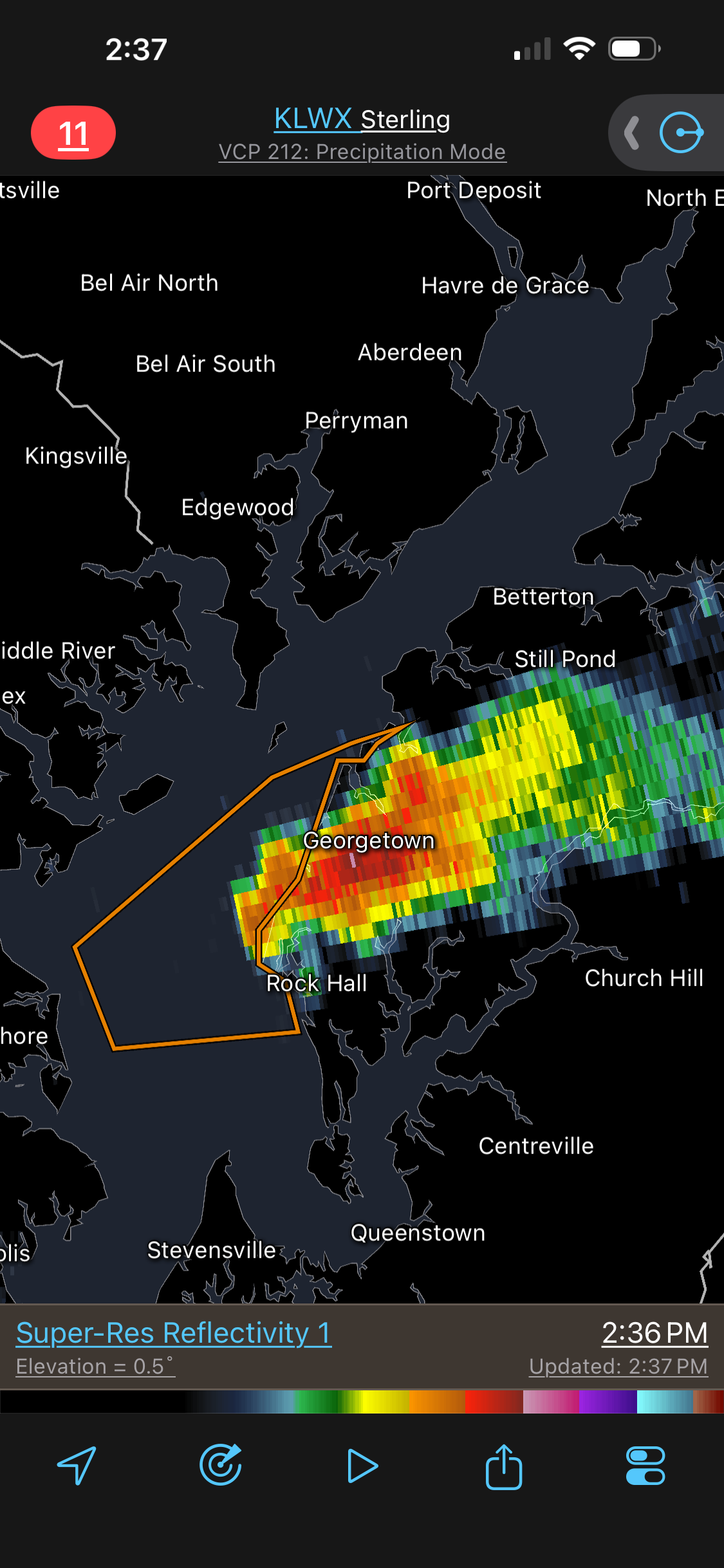
definitely a hook and rotation on velocity scans -
19 days since last measurable rain here. Hoping to end that today or tomorrow but outflow from the main line east of here has passed over, probably killing the chance
-
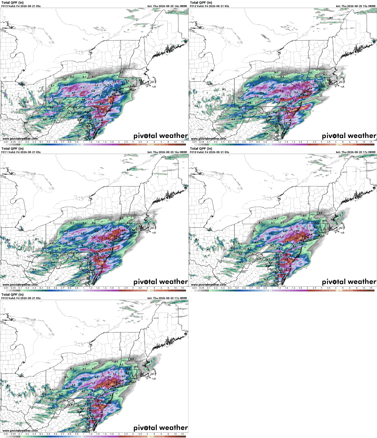
12z euro is similiar to the HRRR NYC/LI/S CT under the gun
-
That sure looks like a supercell for Loudoun
-
Surprised no tor watch. 5% typically means one here/ And w/ the CIG1 hatched area? Georgteown storm appears supercellular.
-
Blue
-

2026 Mid-Atlantic Severe Storm General Discussion
Eskimo Joe replied to Kmlwx's topic in Mid Atlantic
If you want some real giggles, head on over to the SPC meso analysis and see where the Violent Tornado Parameter (located under Composite Indices) is bullseyed. -

2026 Mid-Atlantic Severe Storm General Discussion
SnowenOutThere replied to Kmlwx's topic in Mid Atlantic
I would be surprised if the bay bounties didn't get a TOR watch.- 2,048 replies
-
- 1
-

-
- severe
- thunderstorms
- (and 7 more)
-
2026 Mid-Atlantic Severe Storm General Discussion
Eskimo Joe replied to Kmlwx's topic in Mid Atlantic
Severe Thunderstorm Watch coming out. A smaller Tornado Watch may be right on it's heels.- 2,048 replies
-
- 2
-
-
- severe
- thunderstorms
- (and 7 more)
-
Glad I just snuck in a clunky meniscus fueled shoot around in before a meeting because it looks like Frederick is still incapable of missing storms.
-
-
I feel Sorry for you. But you are right, has to be better. I've been a United Man, but they frustrate me too. My son is a huge Chelsea fan. Hopefully they all stick it to Arsenal this year.
-
Severe Watch likely
-
.thumb.gif.f92b16c631a1d15d405ed77b33f0710d.gif)
Augdewst 2026: Summer's Last Stand
Torch Tiger replied to Prismshine Productions's topic in New England
1.5-2.5" next 5. We'll see -

E PA/NJ/DE Summer 2026 Obs/Discussion
Kevin Reilly replied to PhiEaglesfan712's topic in Philadelphia Region
This seems underway just northeast of Dover Delaware moving NE into Southwestern NJ that is some pretty heavy-duty flooding rains there moving NE. -
Hrrr been bouncing around as usual
-
looks like thats it for us
-
Rained briefly here at Coppin about an hour ago, now clearing up with patches of blue sky and grey clouds. Oppressively humid though.
-
Latest HRRR dry slots most of that area
-
-
Got clipped by a heavy downpour 0.09
-
Rain has begun here. A few brief heavy downpours but they moved through quickly. Radar filling in.
-

-
Sun has broke through over here. 85/76/77
-

Augdewst 2026: Summer's Last Stand
Cyclone-68 replied to Prismshine Productions's topic in New England
Once again the same area struck about 100x this summer. It’s getting old