All Activity
- Past hour
-

2026-2027 Strong/Super El Nino
bluewave replied to Stormchaserchuck1's topic in Weather Forecasting and Discussion
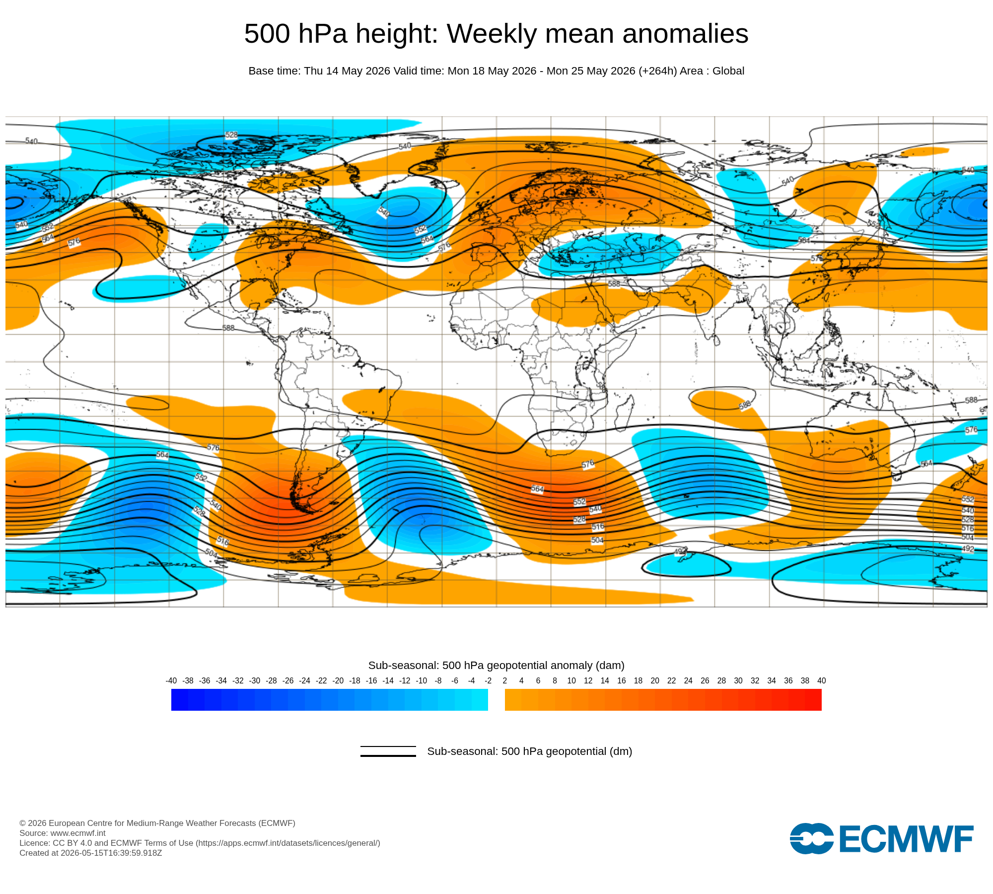
You can see the general outline of the May El Niño 500 mb composite taking shape with alterations probably due to the competing marine heatwaves. The coming near to record May heatwave forecast for the East next week is much warmer than we typically see with such strong developing El Niños. Stronger Southeast ridge could be a function of the weaker RONI relative to ONI and more general subtropical ridging adding a more Niña-like flavor to the mix. The May Western North America El Niño ridge is located a little further SW than usual with the weaker Baja trough than they typically see.

-
GFS has backed off a lot, but still has a few inches for the Palmer Divide and foothills. NAM also has it. Waiting for the 12z Euros to kick off.
-

Central PA Spring 2026 Discussion/Obs Thread
TheDreamTraveler replied to Voyager's topic in Upstate New York/Pennsylvania
Main thing that sucks about it hitting 95 for 2 days straight this early is the pool water is nowhere near warm enough to even take a dip in lmao especially with how cold its been it hasn't had much time to heat up -

Winter 25-26 (All Snowfall Maps & Season Total)
Sey-Mour Snow replied to The 4 Seasons's topic in New England
Pretty cool site thanks! -
Sun
-
Low of 48 today. Had to wear a jacket on our dog walk. Might be the last 40's we see this spring.
-

2026-2027 Strong/Super El Nino
snowman19 replied to Stormchaserchuck1's topic in Weather Forecasting and Discussion
“#ElNiño is taking over the global atmosphere. We're gonna get a brief spat of trade winds over the East Pacific due to an Equatorial Rossby Wave, followed by another large WWB as the MJO traverses back into the Pacific. Models are showing low-frequency forcing setting up over the East/Central Pacific. Looking like a very strong, classic, coupled, canonical +ENSO event starting.“ -

E PA/NJ/DE Spring 2026 Obs/Discussion
RedSky replied to PhiEaglesfan712's topic in Philadelphia Region
That was an anomalous heavy frost i hit 32F There's a big difference between 32F and 25F low -
What's the latest you've seen snow there? I don't think I've seen it more than a day or two after Mother's Day here.
-
2.04"
- Today
-

2026-2027 Strong/Super El Nino
A-L-E-K replied to Stormchaserchuck1's topic in Weather Forecasting and Discussion
get ready 2 torch -

2026-2027 Strong/Super El Nino
LakePaste25 replied to Stormchaserchuck1's topic in Weather Forecasting and Discussion
My cool/wet summer for the great lakes will go up in flames unless we start seeing this -
The other day was nuts with gusts near 50mph for a few hours. The resulting sandstorm will keep people off the beach regardless. When the sand is dry and winds are over 40 you have to be insane to be on the beach. .
-
You definitely value heat more than me, so I understand your reasoning. I hate the heat. I only like 90+ when I'm at the beach. Otherwise, it's annoying. I do wish we could have more cool and sunny days, but this time of year, cooler weather usually indicates broad troughing or shallow cool from back door fronts. Can't have the cake and eat it too, so I get it. Alas, we also need rain, so getting warm and humid can at least open the door for convection. On to summer I suppose!
-
The one big event, Jan 25-27, parlayed a modest 0.77" LE into 19.6" of fluff, ratio 25:1. Next biggest was 8.5" on Christmas Eve. Only once before have I recorded a storm of 15"+ with ratio above 16:1, at Fort Kent in December 1981 - 15.5"/0.68" for 23:1
-
Brutal
-
-

Central PA Spring 2026 Discussion/Obs Thread
WmsptWx replied to Voyager's topic in Upstate New York/Pennsylvania
Dear Christ I hope that was the end of the gloomy weather. Seeing the clear sky this morning when waking up lifted my spirits, but also made signing into work difficult. -

2026-2027 Strong/Super El Nino
Stormchaserchuck1 replied to Stormchaserchuck1's topic in Weather Forecasting and Discussion
It will probably go Super, I just don't think it will be an all time record breaking event on the RONI. Were also not seeing a +PNA, or -NPH in the next 15 days. -
90 Sunday in the interior if these new NAM 12z grid numebrs are right. I don't think its profile over Logan is right 18z+, tho. NAM is spuriously cooling the 850 mb level where it should be roasting them because that day has a westerly wind burst in the BL to 20 kts coming down from 280 degree direction, under superb solar max heating (off a high launch no less...). The mixing quotient should have that level closer to what it's doing over LGA, rising a couple clicks...not falling. So, it keeps the exit temp in the 82 range via adiabats when it should be about 91 given so going to toss ... It will be interesting to start delving into these kind of OCD inspections when the new model versions cripple the forecast community in a couple of months. HAHA
-
2026-2027 Strong/Super El Nino
snowman19 replied to Stormchaserchuck1's topic in Weather Forecasting and Discussion
Regardless of whatever has happened in the past, I don’t think this event will have any problem at all becoming a super El Niño on the RONI or the ONI -
70's on tap today, but was warned on local news last night that some blowing dust could enter the picture from the Dakotas. Skies are a little milky this morning. Gusty W winds today with low RH has a big chunk of the N areas under a Reg Flag warning. Lots of rain coming next week, tho.
-
I needed roof repairs and a new window after that day, not fun.
-
May 15 1998: Damaging tornadoes impact Minnesota. One tornado hits a flea market in Albany, killing one person and injuring 30 others. 102 homes are severely damaged in the northern Twin Cities due to another tornado. 1969: Torrential rain occurs in Synnes Township, dumping 8 inches of rain in three hours. For Friday, May 15, 2026 1834 - The Northern Atlantic Coast States were in the midst of their greatest May snowstorm of record. The hills around Newbury, VT, were covered with two to three feet of snow. (David Ludlum) 1968 - A tornado touched down southwest of Anchorage, AK. It was the second of just three tornadoes reported in Alaska since 1950. (The Weather Channel) 1972 - The worst ice jam flooding of memory for long-time residents took place along the Kuskokwim River and Yukon River in Alaska. It was the first time since 1890 that the two rivers "flowed as one". The towns of Oscarville and Napaskiak were completely inundated. (15th-31st) (The Weather Channel) 1987 - Unseasonably warm weather returned to the north central U.S. Seven cities reported record high temperatures for the date, including Janestown, ND, with a reading of 96 degrees. Thunderstorms in Utah produced five inches of rain south of Bicknell. (The National Weather Summary) (Storm Data) 1988 - Thunderstorms in Oklahoma produced wind gusts to 80 mph in Oklahoma County, and baseball size hail at Pawnee. Hail piled up to a depth of 18 inches south of Pawnee. Hail damage in Oklahoma was estimated at close to 25 million dollars. Thunderstorms in the Upper Midwest produced golf ball size hail around Cleveland, OH, and wind gusts to 83 mph at Angola, IN. (Storm Data) (The National Weather Summary) 1989 - Thunderstorms developing along and north of a stationary front produced severe weather in the south central U.S. Thunderstorms spawned eleven tornadoes, and there were 145 reports of large hail and damaging winds. Softball size hail caused 2.1 million dollars damage at Sherman, TX. (The National Weather Summary) (Storm Data) 1990 - Thunderstorms produced severe weather from the Central Plains Region and Oklahoma to Indiana and western Kentucky. Thunderstorms spawned fifteen tornadoes, including seven in Oklahoma, and there were 165 reports of large hail or damaging winds. A tornado killed one person, injured a dozen others, and caused four million dollars damage at Stillwater, OK. Another tornado injured eight persons at Foyil, OK. Thunderstorms in Oklahoma also produced wind gusts to 92 mph at Oologah Lake, and softball size hail at Canton and north of Oakwood. (The National Weather Summary) (Storm Data)
-
Maine seemed to have fewer juicy SWFE this past winter (just the one big one), which can be jackpots for western / northern areas.