All Activity
- Past hour
-
Not buying Webb's latest. He had cold/blocking scenarios loaded up and ready to go. His science behind the logic is sound here in that we need change, but it's not curtains through February from what I'm seeing. To attribute this all to Nina when the actually ENSO state is so weak in that direction is also a bit incorrect.
-
It’s not a perfect comparison but trusting a single good poster on Twitter for how the whole season is gonna go will work as well as trusting a fantasy football analyst for your week to week start/sits. Nobody knows. Strange things happen. Random players can have a home run game. We’ve got 3 months to go in winter where it can be significantly snowy around here. Cannot possibly wave a white flag yet.
-
Webb says we're screwed https://x.com/webberweather/status/2002755646454993016 https://x.com/webberweather/status/2002759593269792869
-

Winter 2025-26 Short Range Discussion
Brian D replied to SchaumburgStormer's topic in Lakes/Ohio Valley
Christmas Day may be a LES or lake enhancement with synoptic snows across NE MN. Looks like a possible def zone between HP n LP setting up. A long fetch from the ENE across the Lake usually gives something, especially with a boundary hanging out. -

MO/KS/AR/OK 2025-2026 Winter Discussion
NWAflizzard replied to stormdragonwx's topic in Central/Western States
This has to be the biggest spread I’ve seen on the AO forecast.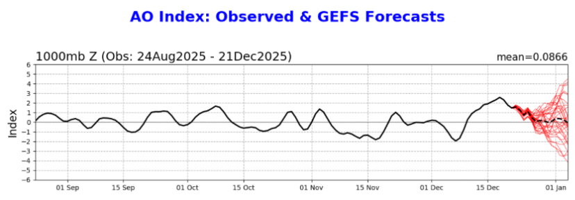
-
It has zero ensemble support so we’ll see. Even if it did, I don’t want to be in the bullseye for at least another 6 days. That time period does look interesting though. It seems like we get a brief break from warmth but it’s an all or nothing type of look.
-

Possible Light Snowfall (1" - 4") on Tuesday Dec 23
WeatherGeek2025 replied to Northof78's topic in New York City Metro
this would be considered a white Christmas -

White Christmas Miracle? December 23-24th
WxWatcher007 replied to Baroclinic Zone's topic in New England
Back to wx. It’s definitely tenuous for coastal areas, but you can see how a slightly more robust system is very good for much of the subforum being in striking distance of a widespread 2-4” event. I’d still lean 1-3” generally given the track and possibility we can’t amplify this to its ceiling, but still solid minor snow in advance of the holiday. -
I don't follow anyone about long range stuff and usually stick to my own thoughts but wasn't Webb on the cold/blocking train just a few weeks ago? When all guidance was unified in the general idea? Of course it didn't work out and here we are but wouldn't it be the same mistake to jump all in on what lr guidance is unified on now? Long range weather is one fickle beast. If it was easy to predict beyond a couple weeks we could all just be energy traders and retire in a couple years. But it doesn't work like that. Not even close really. I never thought this would be some kind of awesome snowy winter but to marry the idea that it's "mostly over" already is a blunder imho. Analogs are nearly unified that the way out of the current persistence is a cold and/or stormy period in the east. It makes sense to me as the winter see-saw has been part of the personality already and likely to continue (imho only). I personally don't agree that things are dire and a persistent hostile snow pattern is here to stay. If anything, I expect a 2 week period in Jan to be pretty good for chances. Luck and timing hold the cards for production but my money is on real winter returning for a decent period in Jan. Guidance is currently starting to pick up on the idea late in the first week of Jan. I'm starting to expect that trend to continue. Wait and see for now.
-

December 2025 Short/Medium Range Forecast Thread
*Flash* replied to John1122's topic in Tennessee Valley
Happy Winter Solstice, everyone!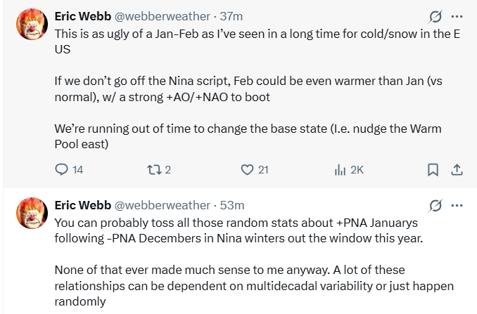
-
There's very little to be optimistic about right now. Add in the fact that it doesnt snow during February or March during Ninas and we got an uphill battle
-
December to Remember

-
https://x.com/webberweather/status/2002759593269792869?s=46
-

Possible Light Snowfall (1" - 4") on Tuesday Dec 23
MJO812 replied to Northof78's topic in New York City Metro
Gfs.thumb.png.ba86e96202852de16443e6febaba632d.png)
-
(002).thumb.png.6e3d9d46bca5fe41aab7a74871dd8af8.png)
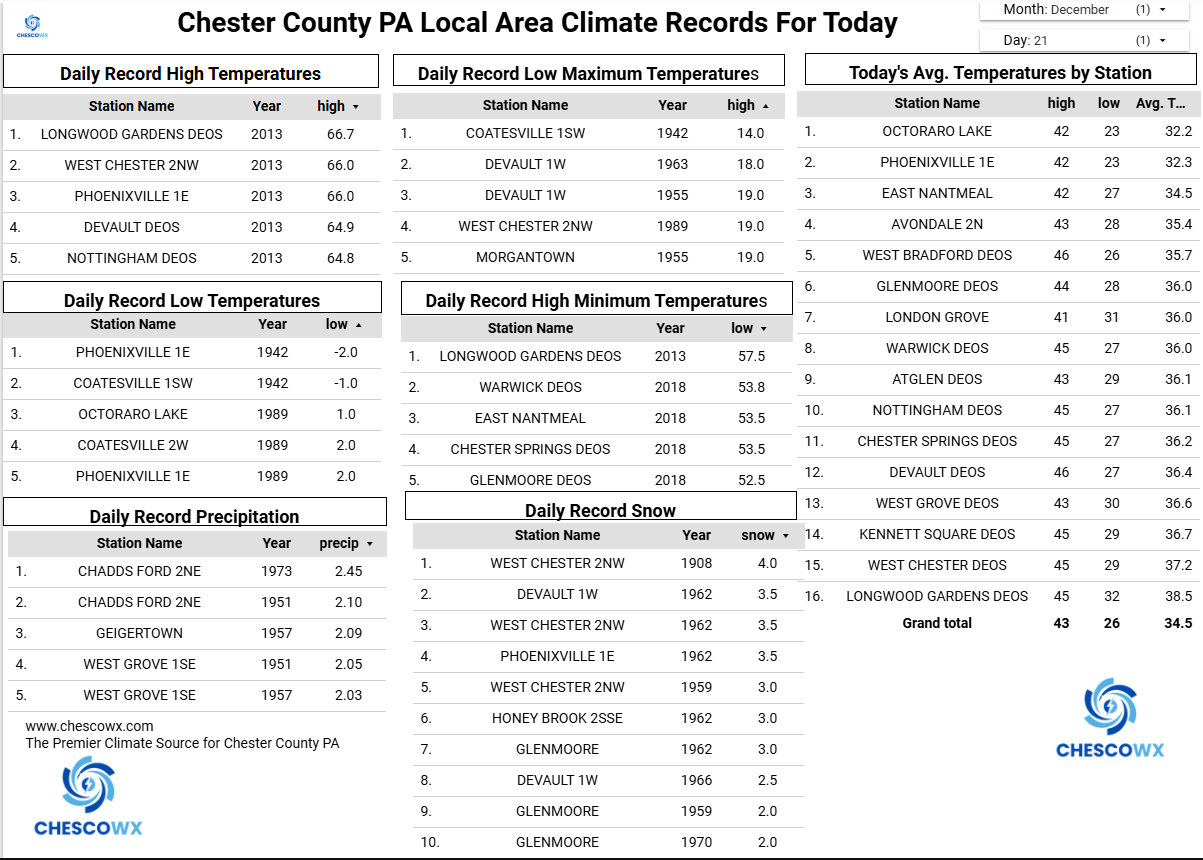
Central PA Winter 25/26 Discussion and Obs
ChescoWx replied to MAG5035's topic in Upstate New York/Pennsylvania
Happy first day of Winter to those that celebrate! We are at about our high temperatures for today with a cold front passing through this morning. Today’s temperatures will drop to freezing by evening. Below normal temperatures tomorrow with near normal high temperatures through Christmas Day. The warmest day of Christmas week looks to be on Boxing Day with temperatures well into the 40's and maybe even 50 in some valley locations. We turn chilly again on Saturday. It looks increasingly likely that snow will arrive by Tuesday morning's rush hour. We should see less than an inch of snow before any change to rain for most of the area with more up toward the Lehigh Valley. Additional rain shower chances for both Christmas and Friday.
-
E PA/NJ/DE Winter 2025-26 Obs/Discussion
ChescoWx replied to LVblizzard's topic in Philadelphia Region
Happy first day of Winter to those that celebrate! We are at about our high temperatures for today with a cold front passing through this morning. Today’s temperatures will drop to freezing by evening. Below normal temperatures tomorrow with near normal high temperatures through Christmas Day. The warmest day of Christmas week looks to be on Boxing Day with temperatures well into the 40's and maybe even 50 in some valley locations. We turn chilly again on Saturday. It looks increasingly likely that snow will arrive by Tuesday morning's rush hour. We should see less than an inch of snow before any change to rain for most of the area with more up toward the Lehigh Valley. Additional rain shower chances for both Christmas and Friday.
-
You all risk upsetting @BxEngineand being banned. just a friendly reminder of his post the other day..
-
Might be time to stop checking this thread, for my mental health.
-
Watch the flood gates open when the Niña ends like in 2018.
-
White Christmas Miracle? December 23-24th
WxWatcher007 replied to Baroclinic Zone's topic in New England
In his defense, he’s also been pretty relentless in talking about how the awful 80s may be comparable to now. He may lean on uncertainty being an avenue to optimism and I can see how that would wear some people out, but preordaining every complex or suboptimal setup as evolving into the worst case scenario or announcing that your hand is firmly on the plug and you’re ready to pull after every model cycle ain’t it either. It’s a bad snow regime. I think 95% of the subforum understands that. But that does not mean that every chance this season must also be a disaster in waiting, even if some actually are in our backyards. You’ve been around long enough to know that our climo skews toward smaller messy events far more than it does 6-12” or even 4-8” ones, especially in your region. If you want people to be as frustrated and despondent as you are, flash the canines and say it. Wolfe does it unapologetically. -
I don’t know how you all feel about Webb. In my time following him, it seems like he’s been about as informed and accurate as anyone I’ve come across. So him saying this does feel like a massive sucker punch.
-
dr Not you. The guy you responded to haha
-
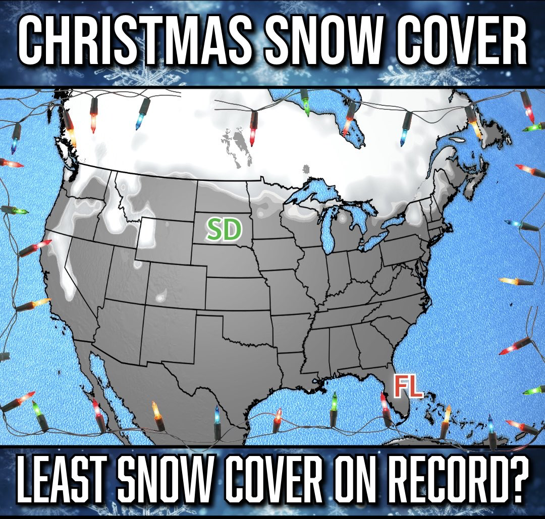
Morning low of 5F. Warmup begins today. Going to be a photo finish whether our snowpack survives for a white Christmas.
-
.
-
MJO moving into phase 2, PNA tanking, NAO going from negative to neutral. Too soon to call the month shot but January is looking extremely bleak. We’re losing the cold in Canada and likely will be looking at a total reset needed on this side of the globe. In other words, this is trending towards a disaster as we head into prime climo. Looks like a pure Nina pattern developing with continental air. My god any optimism has faded at rapid rates this year


.png.dfe12cd488c2b36d37bda15e3cc5f63f.png)