All Activity
- Past hour
-
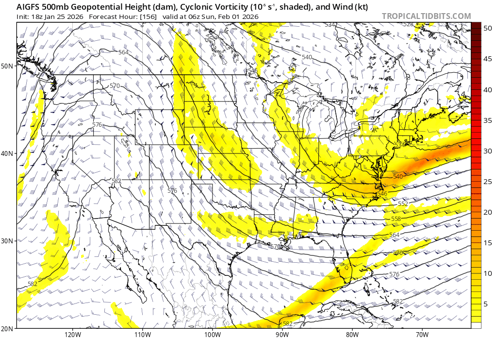
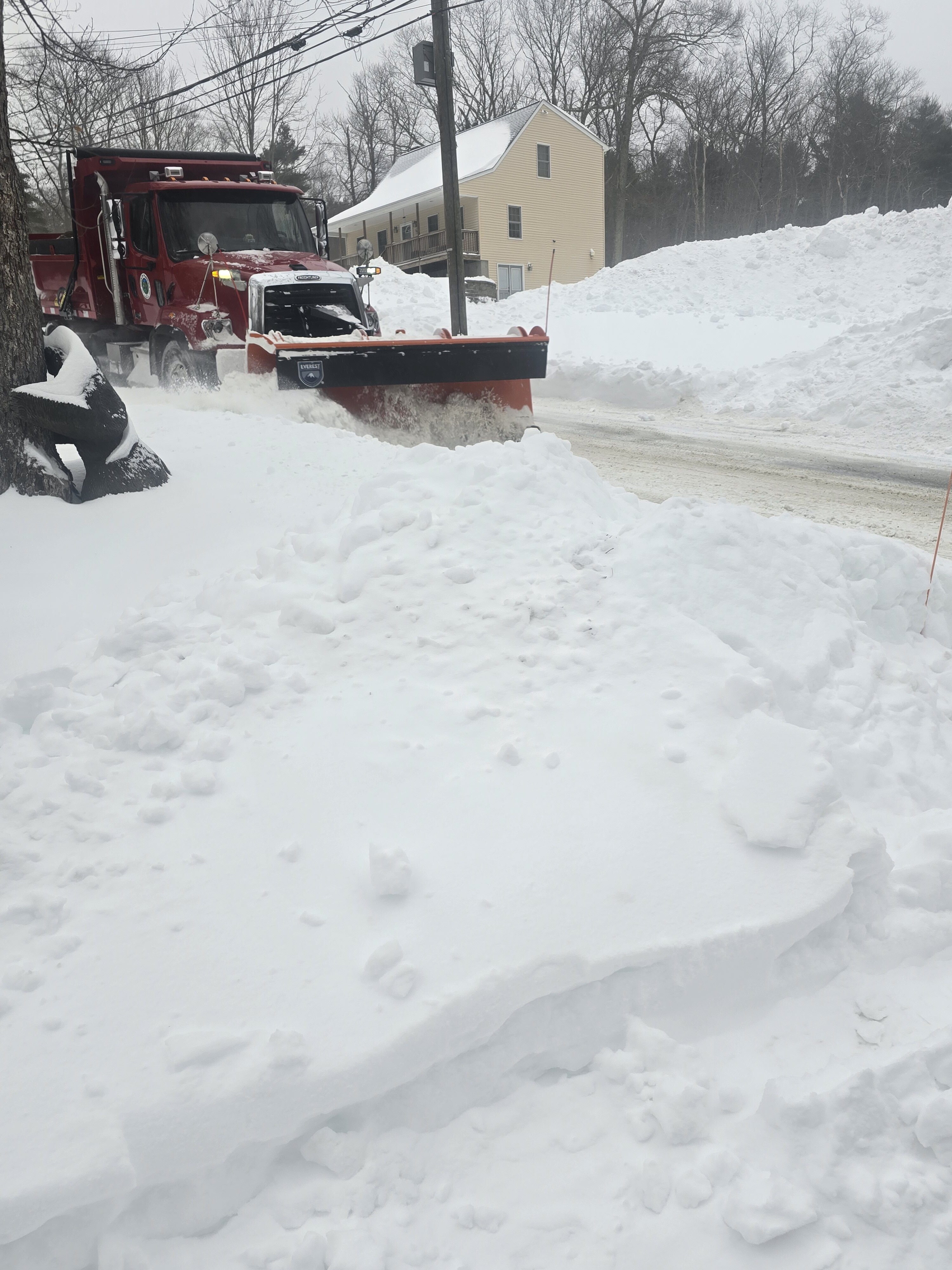
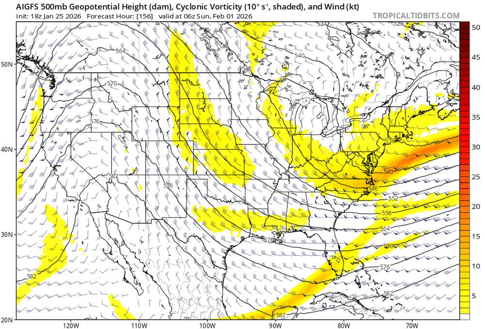
 Sorry not fresh, but wanted to add to thread for legacy / archival purposes... I thought this was a nice bit from the Box AFD last night detailing the storm. I'm still not sure why snowgrowth wasn't as good as many (including this AFD) expected... but with Cocorahs having generally 1.4-1.7 qpf / snow totals 15-20" (@Ginx snewx's call all week) with areas 20"+ in the expected north shore and Worcester hills... seems like SLRs ~10-12:1? Still achieved 1-1.5" / hr rates for almost entire duration. KEY MESSAGE 1...Major winter storm continues this evening and overnight. Difficult to impossible travel conditions persist through 12-2am with 1-3" per hour snowfall rates. After a bit of an early start, snowfall rates have increased to 1 inch per hour across much of the CWA this afternoon. These dangerous travel conditions continue well into the overnight as low pressure deepens offshore helping to increase mid level frontogenesis. The bulk of the snow falls through about 06z with gradual improvement into Monday morning as a dry slot works its way into the region. Storm totals are still holding steady as of the 18z update with totals expected to be in the 12"-18" range across the majority of southern New England, with 8"-12" expected on the Cape, Islands, and immediate southern coast. The higher elevations and northeastern MA will likely see 18"-24" for much of the 495 corridor including the Boston metro area. Coastal low takes shape off the Del Marva Peninsula this afternoon helping to further increase mid-level frontogenesis. In response, a deep and robust layer of lift will extend through much of the column including the dendritic growth zone (DGZ). BUFKIT soundings even show the potential for 2 favorable layers for dendritic growth, one in the mid to upper levels, and another closer to the surface with the deep and substantial near surface cold pool. Attention turns from mid level frontogenesis to lower level frontogenesis (925- 850mb) as a steep low level temperature gradient associated with an incoming coastal front approaches from the south. Coastal front initially races north across the ocean then slows to a crawl this evening as it encounters the wedge of low level cold air on land. Warm front aloft still continues north overnight, so expecting +SN to slowly transition to heavy sleet along the south coast and move inland between 00-05z Furthest inland extent looks to be along west to east corridor extending from Providence RI to Plymouth MA. In these locations the mid level warm nose increases to +1-2C. Perhaps a bit more exciting for us weather lovers is the non-zero chance for +TSSN as the mid levels warm enough for some elevated instability this evening into the overnight. Northeasterly LLJ increases to 30-40kts this evening as the low center passes just S of Nantucket. Thus, could see a period of gusty winds and blowing snow especially over the southern waters, Cape and Islands. HREF blizzard probs remain around 20%-30%, between 22 and 05z. The limiting factors for blizzard conditions along the south coast will be sleet and lower snow ratios as well as the short lived nature of the gustiest winds. Further inland, the mid level warm front stops short of changing the precip type to sleet and instead brings a lower ratio snow that that will help to cap totals between 12 and 18 inches for much of the interior. Impressive temperature gradient develops overnight with surface temps rising to near 32 as far inland as PVD but staying in the lower teens at ORH on the other side of the surface warm front! Prolific snow winds down from SW to NE as a mid level dry slot pushes into southern New England as 500-700mb RH values fall to 40- 60%. RH values like these are hostile to snow crystal growth and instead favor a period of "snizzle" or flurries. Any lingering snow eventually tapers to light flurries. Last hold out for light to moderate snow will be northeastern Massachusetts as northeasterly flow on Monday will allow for ocean-driven snow showers to persist into Monday afternoon. The next key message will better focus on Monday`s snowfall.
 -

Possible coastal storm centered on Feb 1 2026.
Typhoon Tip replied to Typhoon Tip's topic in New England
This evolution is less likely than the previous handling. +PNA ridge axis demos zero propagation toward the E between the 12z and 18z; there's really no mechanical reason to see a foisted deep layer farther E.. If anything, the previous run ( and this one certainly by same convention - ) was too far E. This was insults physical reasoning by stretching the flow .. .mostly arbitrary. -

The “I bring the mojo” Jan 30-Feb 1 potential winter storm
SouthboundYank replied to lilj4425's topic in Southeastern States
Good early reads, and TY all...but you know, if that would come to fruition, I'd gladly ask the snow gods to send that modeled wx to any of the surrounding environs except Myrtle Beach. Having said that, The Wilmington NWS team posted a good afternoon disco concerning the upcoming weekend...I couldn't include all of it in the screen cap, but there was a good two paragraphs of all of the moving pieces prior to what I pasted below.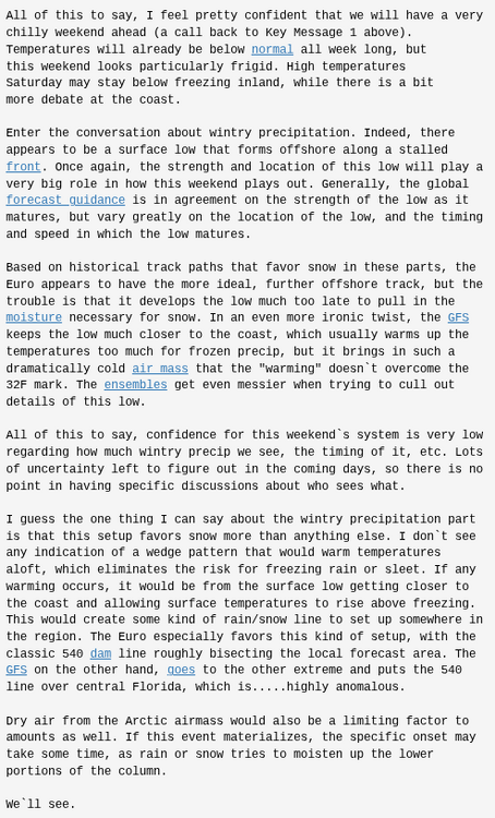
-
 Did the neighbors ever pick up that Giants trash or is it hopefully buried until Morch?
 -

The “I bring the mojo” Jan 30-Feb 1 potential winter storm
olafminesaw replied to lilj4425's topic in Southeastern States
We can't seem to get a trough to tilt negative to save our lives the last few years. Not being negative about the prospects for this storm, just an observation -
The trend on the Aifs is undeniable. Everything backing up west over the last 24 hours. Not there yet but another day of trends like this and it will be.
-
Upper levels are way colder
-
 Dare I say .. Poundmetown right now. It is ripping
 -

Richmond Metro/Hampton Roads Area Discussion
chris624wx replied to RIC Airport's topic in Mid Atlantic
18z GFS too far OTS for most of us -
Looks to have this weekend's fish storm. Must be right! Lol
-
Same here. Have post storm blues as it is...
-
One of my all time favorites. My younger son still plays basketball in the gym of the middle school where I watched that storm. .
-
I cleared the front walkway and sidewalk. Big freakin’ bricks of ‘snow’. I used a flat ice thingie pick and it worked like magic.
-
The early 1970s were horrible for snow. The winter of 1972-1973 had no measurable snow for the area from around Middlesex County to Trenton! 1976-1977 was the bitter cold season, but with only around 25 inches of snow.
-

The “I bring the mojo” Jan 30-Feb 1 potential winter storm
StantonParkHoya replied to lilj4425's topic in Southeastern States
AI is a solid NC snow, really solid Raleigh east. . -
Wouldn't worry about 18z op runs this far out. .
-
 Went out with my cane on the deck yep frzn. Snowing again
 -
It’s nice to be closer to climo than not given the last few winters
-
Dare I say this is where we want it right now
-
The 1st one was not either, it was expected to be south although the morning prior or even 36 hours prior models began making a shift to the north.
-
Plow it in until Mayorch
-

Possible coastal storm centered on Feb 1 2026.
dryslot replied to Typhoon Tip's topic in New England
Kind of acted as a kicker. -
 Big aggregates stacking up here.
 -

E PA/NJ/DE Winter 2025-26 Obs/Discussion
Prairie Dog replied to LVblizzard's topic in Philadelphia Region
down here not many drifts However, we had to use a flat head shovel to loosen the accumulated sleet on the driveway. I then used the snow thrower. Otherwise the snow thrower rode along the top Since you are Upper Bucks, maybe less sleet Good luck -

Possible coastal storm centered on Feb 1 2026.
RUNNAWAYICEBERG replied to Typhoon Tip's topic in New England
The trailing backside energy is late too and tries to spin up it’s own closed h5.