All Activity
- Past hour
-
1 here right now, still looking for our 1st below 0 low. got about 15 minutes to get it, until the sun is really up.
-
Richmond has had 2 events now. Big winter for them even if nothing else happens rest of the way
-
After midnight highs today. This happens quite a bit with Arctic fronts. Some of the great Arctic outbreaks from 77 to 94 would have had lower daily maxes if the front was just a little faster. SXUS51 KOKX 080557 OSOOKX New York City Metropolitan Area Weather Roundup National Weather Service New York NY 100 AM EST MON DEC 08 2025 CITY SKY/WX TMP DP RH WIND PRES REMARKS Central Park PTCLDY 38 24 57 VRB7 30.05R WCI 33 LaGuardia Arpt PTCLDY 40 21 46 W16G23 30.03R WCI 31 Kennedy Intl PTCLDY 37 27 67 W9 30.05R WCI 30 Newark Liberty PTCLDY 37 25 61 W8 30.04S WCI 31 Teterboro Arpt PTCLDY 36 25 64 W7 30.03S WCI 30 Bronx Lehman C N/A 37 27 65 W6 N/A WCI 33 Queens College N/A 39 27 60 W9 N/A WCI 33 Breezy Point N/A 37 N/A N/A W12 N/A WCI 30 Brooklyn Coll N/A 39 28 65 W10 N/A WCI 32 Staten Island N/A 36 28 75 W6 N/A WCI 31
-
My Saturday night TV line up as a kid in the 70’s: Emergency! Mary Tyler Moore The Bob Newhart Show And if I was lucky, I got to stay up for Carol Burnett’s monologue
-
Nice little early season snow event for North Carolina and Virginia. Wish it was here but happy for them.
-
Still BN there in Islip though.
-
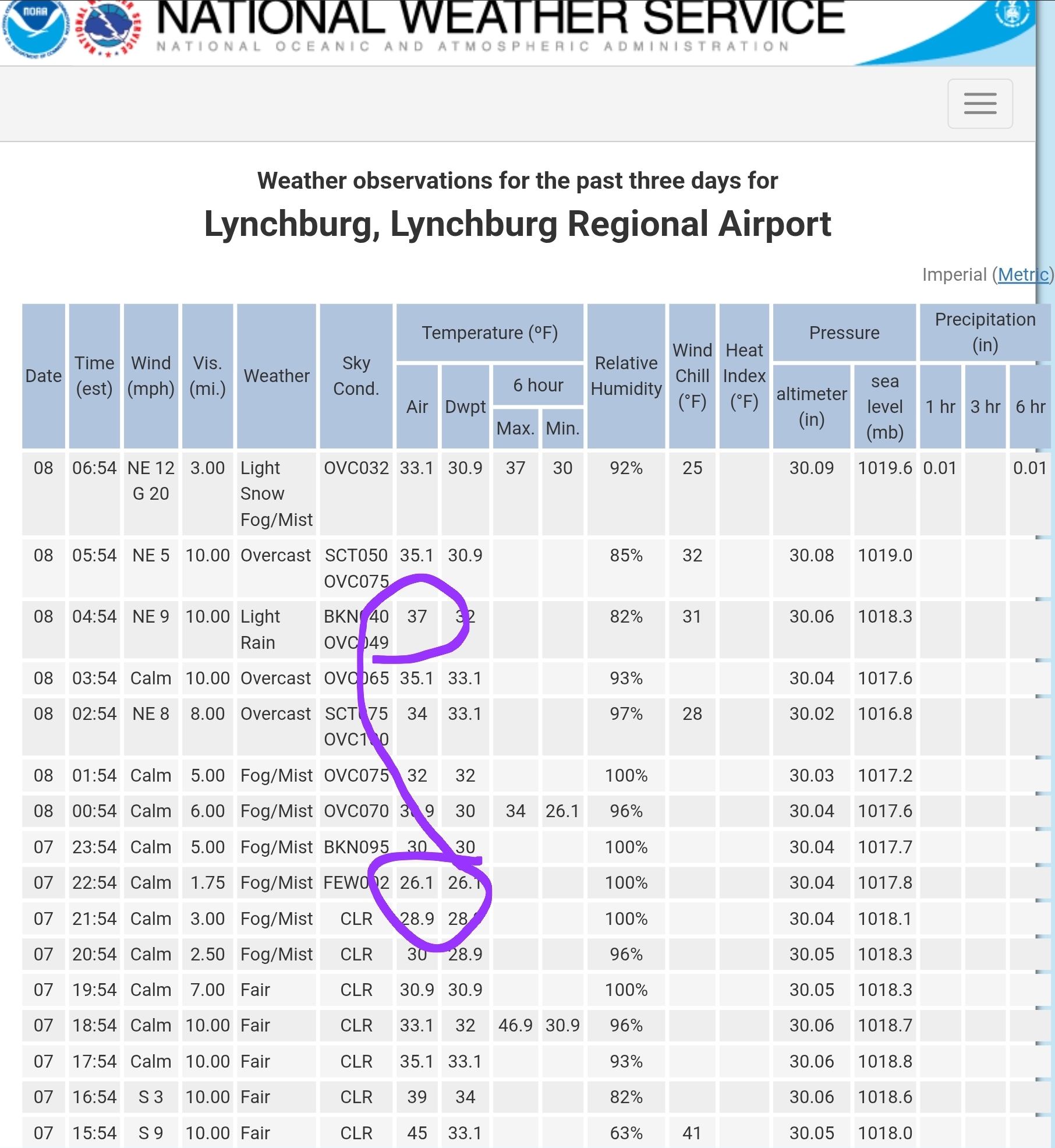
32 and snow here in Forest, maybe a half inch? Here was the temp spike in Lynchburg from the clouds..

-
No it’s more than that. Past three day we’re running like 5F-7F colder. As I said, there’s been a very significant seasonal gradient persistent for more than just one storm/pack. Highs past three days: PSM: 23, 34, 36 Islip NY: 36, 45, 46
-

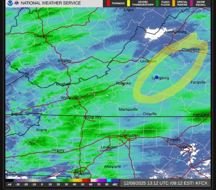
The Monday wintry event potential (12/8/25)
landof2rivers replied to GaWx's topic in Southeastern States
There's some wind now where earlier nothing was moving. Up to 37*; I’m guessing (hoping) the wind is the cold air moving in? -

The Monday wintry event potential (12/8/25)
Buddy1987 replied to GaWx's topic in Southeastern States
Cul de sac and my driveway starting to cave. Getting close to the freezing mark now down to 32.7 -
Short range has gone away from the bands coming in later. Can't say I'm surprised.
-
Today's high temperatures have already occurred. They were above freezing for just about everyone.
-

Winter 2025-26 Short Range Discussion
OrdIowPitMsp replied to SchaumburgStormer's topic in Lakes/Ohio Valley
Classic GFS v Euro battle for the Tue/Wed system here. Either 4-6” of snow or 34 and rain. -
On Christmas? In 2015 when it was humid and 70, I was sweating my balls off. I’ll pass on that.
-
Both the GEFS and EPS extended show a trend toward more normal temps as we head into the end of December into January, but not a torch.
-
Looking around at webcams, Boone is getting hammered right now
-

The Monday wintry event potential (12/8/25)
BornAgain13 replied to GaWx's topic in Southeastern States
Heavy Snow here. Accumulating quickly. Temp down to 32.9 -

December 2025 regional war/obs/disco thread
TauntonBlizzard2013 replied to Torch Tiger's topic in New England
I mean, 60 degrees on Christmas Eve certainly beats cold, wind, and bare ground. If it’s not going to snow I’ll take a few nice days. Sign me up -
Yeah. Rockaway wont even see 30F today.
-
Well at some point things have to change. My son had a nice frustrating moment looking at the models. Just looked at the euro and said this is BS. Couldn’t even be mad at the cursing. Proud daddy moment. I just looked at him and said welcome to my youth. Just be glad you were around for some biggies since I had none until high school.
-
Looks like the RR storm.
-
Wayyyyy too early to say that my friend. But I'll take a breakdown for a while as we desperately need a reshuffle.
-
You’re in a great spot looking at radar. UVA got luckily with some good banding Friday so I doubt we reach those totals but either way I’ll enjoy today!
-
We’re always the bridesmaid, never the bride
-
This is so much of a moister atmosphere when compared to friday. This is all steady, accumulating snow
.thumb.jpg.ad3a2e31d30aff035044689b311a0540.jpg)