All Activity
- Past hour
-

December 2025 regional war/obs/disco thread
moneypitmike replied to Torch Tiger's topic in New England
And Sparky lyle….first reliever to get the cy young award. -

White Christmas Miracle? December 23-24th
Kitz Craver replied to Baroclinic Zone's topic in New England
Happy the NAM is moving in the right direction with this. If it was steadfast in skimping SNE I’d be waving the Bruce Willis flares -

Central PA Winter 25/26 Discussion and Obs
paweather replied to MAG5035's topic in Upstate New York/Pennsylvania
I’m liking this! Thanks Chris -
It reminds me a little of January 2022
-

December 2025 Short/Medium Range Forecast Thread
GaWx replied to John1122's topic in Tennessee Valley
This is one of the biggest and most widespread changes toward colder on the EPS mean when going from 2 weeks out to one week out. In reality, most of the colder change has been just since the Friday runs! It’s all because the -NAO got much stronger and pushed back from the NE despite the strong Aleutian ridge remaining! -
(002).thumb.png.6e3d9d46bca5fe41aab7a74871dd8af8.png)
E PA/NJ/DE Winter 2025-26 Obs/Discussion
ChescoWx replied to LVblizzard's topic in Philadelphia Region
As we talked about earlier the forecasts have changed significantly for Friday - per the latest AFD The updated forecast now has highs on Friday in the mid to upper 30s for the I- 95 corridor and west with mid to upper 20s in the Poconos. Areas south and east of the I-95 corridor have highs in the low to mid 40s. Wintry precipitation is now the result for much of the area for at least part of the timeframe from daybreak Friday into Saturday. Mixed precipitation may make it as far south as parts of Delmarva. Warm air looks to gradually filter in through this event which would cause a changeover to rain. Right now, the best potential for this to be a mainly rain event looks to be in parts of Delmarva and southern New Jersey. There is a large amount of uncertainty with the forecast for Friday into Saturday and trends will need to be monitored. Uncertainty remains through the weekend but there are indications that the forecast stays unsettled. -

Pittsburgh/Western PA WINTER ‘25/‘26
colonel717 replied to Burghblizz's topic in Upstate New York/Pennsylvania
Looks like the area could see some brief snow moving in if it doesn't dry up as it gets here.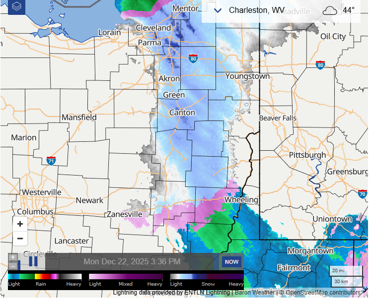
-
Been a while since the coldest air in the hemisphere has been on our side of the pole. We’ll see how things play out as we move through early January.
-

White Christmas Miracle? December 23-24th
Damage In Tolland replied to Baroclinic Zone's topic in New England
Heavy heavy snow -
 Totally bogus. We will have up and down temps until the second week or January then looking colder after that.
 -
10.4” ytd would be nice to finish the month 20”+
-

December 2025 regional war/obs/disco thread
Cyclone-68 replied to Torch Tiger's topic in New England
Being a Sox fan long ago I used to be nervous when Goose Gossage entered the game. Best before Rivera imho -

December 2025 regional war/obs/disco thread
The 4 Seasons replied to Torch Tiger's topic in New England
its not updated yet im sure, if the CWA south of them is going 100% snow and cat pops. -
Tomorrow could be a legitimate 2-4” event here. That, coupled with the potential this weekend, could push me close to 30” for the season and it isn’t even January yet.
-
.thumb.png.4150b06c63a21f61052e47a612bf1818.png)
December 2025 regional war/obs/disco thread
HIPPYVALLEY replied to Torch Tiger's topic in New England
Last I looked, BOX was going for mixed precipitation here. -
One thing is obvious that warm pattern keeps getting pushed back time and time again. The latest Euro Weeklies the most reliable period being the first two weeks show colder than normal temperatures for all the east coast.
-
we get it - you have plenty to eat just like I said, well off westerners aren’t going hungry any time soon doesn’t mean others won’t - or aren’t
-
It would certainly be unusual. The New York City area hasn't seen many 4" or greater snowstorms when the PNA has been negative. Lighter amounts are far more common. Boston is usually favored with 4" or above amounts.
-

White Christmas Miracle? December 23-24th
ORH_wxman replied to Baroclinic Zone's topic in New England
There's def an OES sig on the Cape for later on Christmas Eve. Euro has been showing it and 18z NAM has it too. -
December 2025 regional war/obs/disco thread
The 4 Seasons replied to Torch Tiger's topic in New England
OKX going with categorical "Snow." 80% pops for Friday, seems a little aggressive. Given the wild swings the past 24 hours. Hopefully some agreement tonight/tom and stability in runs. -
Would snowman and MJO mind taking their constant arguing to PM? It’s cluttering up the thread with useless BS.
-
You are setting yourself up to be trolled relentlessly if this fails and if your snowstorm fantasies tomorrow and the weekend/next week fail and make no mistake about it, I will. Hard to believe you’re a cop
-
I like this event. I will be a wintry week.
-
 yea you will definitely beat me on this one. i am thinking no more than an inch here
 -
White Christmas Miracle? December 23-24th
The 4 Seasons replied to Baroclinic Zone's topic in New England
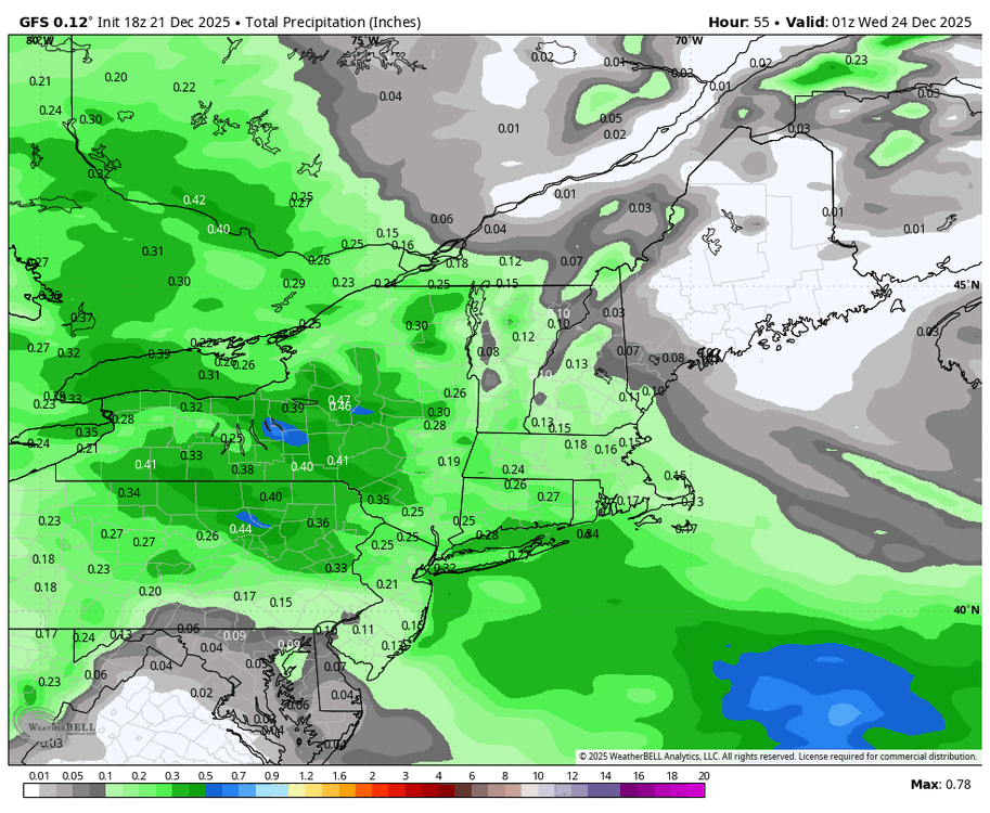
Yeah, GFS has been pretty juiced up last 4 runs. Definitely the wettest model by a lot. I don't expect 18Z to be much different.