All Activity
- Past hour
-

February 2026 Medium/ Long Range Discussion: Buckle Up!
Scarlet Pimpernel replied to Weather Will's topic in Mid Atlantic
"Odds blood this club wants cheering up! Sink me, the place is a mausoleum!" (From the 1934 version of "The Scarlet Pimpernel") Sorry, couldn't resist the quote! The mood in here is almost insanely low, however! Yeah, I get that people are disappointed that we missed out on the big storm in the southeast, but really, it was only a small number of Euro and GFS runs the other week that were showing that we might get hammered as well. For the most part, guidance wasn't all that favorable for us, and we'd be on the northern fringes at best. We were hoping for incremental "improvements" to give us something. I mean, this isn't like the event last February that was literally whisked away near the last minute. Or the pattern shown for days and weeks for February 2024 in the extended ensembles, with this epic classic look, everyone was talking about how that would give us a HECS, etc., and then...it flipped to showing crap and that February was rather warm and uneventful. And even now, people want to argue that our event last weekend was a relative "fail" because it sleeted for hours rather than all or nearly all snow. I can also get that, to an extent, but come on. An area-wide 6-12" combined snow and sleet that turned into a literal glacier. Hell, I can walk on top of the snow and not even have my feet sink into it; like walking on regular pavement (though slipperier)! We've now had a week-plus straight of well below freezing temperatures, and the upcoming week looks cold (though not as cold as last week) with perhaps a bit of a refresher light amount mid-week. When's the last time we had nearly 2 straight weeks of deep winter at that level? But people want to say it's a waste, because we didn't get a foot or more from one or two events. Will it warm up or relax after the next week? Yeah, and that's not really much of a surprise. We're not going to get a solid month or more of cold around these parts. As long as there's a lot of cold lurking up in Canada and we see those 1030+ highs around, and given the overall indications in the longwave pattern, I still have to think we're in a good spot through early March. But even if nothing much happens, this past week or so was still rather amazing! -

February 2026 Medium/ Long Range Discussion: Buckle Up!
WesternFringe replied to Weather Will's topic in Mid Atlantic
The GFS nailed precipitation type in the last storm far better than the Euro for most of Central Virginia. The Euro insisted on .85” of freezing rain, but the GFS said no you will get all sleet after the changeover. The GFS was right and the Euro was wrong. We got zero freezing rain and instead got snow followed by sleet only. .85” of freezing rain vs 0” is a huge difference in outcome regarding travel, power lines, trees, etc. -
Mostly over for them.
-

E PA/NJ/DE Winter 2025-26 Obs/Discussion
BBasile replied to LVblizzard's topic in Philadelphia Region
I'm assuming the whole state is just shut down?
-

Is we back? February discussion thread
Damage In Tolland replied to mahk_webstah's topic in New England
I’ll be happy to grab a couple inches as modeled -

The “I bring the mojo” Jan 30-Feb 1 potential winter storm
gwlee7 replied to lilj4425's topic in Southeastern States
Wow. This one had some of everything. I had fun living through it vicariously. I also learn a lot from the discussions. See you guys later! -
A good start to the new month with a new record 'cool max' of 22.7 degrees, beating 2019's 25.3 degrees. Low was 9.5 degrees right at the 7 am CoCoRaHS report. Wind was WNW at 9 gutsing to 20 mph, WC of -3 to -9 degrees. After we cleared out around midnight last night that nearly full moon made it look like 4-5 pm in afternoon it was so bright shining off the glacier. Had some flurries yesterday evening, but no new accumulation, that all went @Bob Chill and @Buddy1987's way and further south.
-

Jan 30th-February 1st 2026 Arctic Blast/ULL Snow OBS Thread.
Jed33 replied to John1122's topic in Tennessee Valley
There was actually a thin band that moved from NE to SW across Hamblen Co this morning. When I woke up around 6 I noticed it was snowing again. Picked up a tiny dusting on top of some cleaned off surfaces. The band slowly crawled SW and has all but broken up near the Jefferson Hamblen Co. line. I’m not sure what contributed to it other than possibly Cherokee Lake? We’ve seen that before a few times in these arctic setups. -
I’m more impressed with 31F at PBI. Not easy to get below freezing at West Palm Beach
-

Jan 30th-February 1st 2026 Arctic Blast/ULL Snow OBS Thread.
GBOVolz replied to John1122's topic in Tennessee Valley
Where do you get your satellite images from? . -
Records: Highs: EWR: 68 (1989) NYC: 67 (1989) LGA: 66 (1989) JFK: 64 (2012) Lows: EWR: 1 (1935) NYC: -2 (1920) LGA: 3 (1961) JFK: 4 (1961) Historical: 1893 - Thunder and lightning accompanied sleet and snow at Saint Louis MO during the evening hours, even though the temperature was just 13 degrees above zero. (The Weather Channel) 1916: Seattle, Washington, was buried under 21.5 inches of snow, their most significant 24-hour snowfall. A total of 32.5 inches of wet snow accumulated over three days. The Seattle cathedral dome collapsed under the snow's weight. 1920: Atmospheric pressure builds over New England to extreme levels. Barometer in Portland, Maine reads 31.09 inches of mercury (1053 mb), the highest February sea-level pressure ever recorded in the Eastern US. Hartford, Connecticut hits 31.06 inches of mercury (1051 mb). The Eastern US record was set the previous day (January 31, 1920) in Northfield VT at 31.14 in, though it was the same air mass. The mercury dropped to -45° at Pittsburg, NH. The City data comes from Christopher Burt's list of extreme pressures for US Cities (Ref. WxDoctor) (Ref. Wilson Wx. History) (Ref. US Barometer Records by State) The highest air pressure ever recorded in the US was 31.85 inches in mercury (1078.56 millibars) in January 31, 1989 in the city of Northway, Alaska. (Ref. Bob Swanson, USA TODAY's assistant weather editor, November 24, 2005) 1935: Minimum temperature for Washington, DC for the date 6°F (Ref. Washington Weather Records - KDCA) 1947: January 30th through February 8th, a great blizzard occurred in Saskatchewan, Canada. All highways into Regina were blocked. Railway officials declared the worst conditions in Canadian rail history. One train was buried in a snowdrift over a half-mile long and 36.7 feet deep. 1951 - The greatest ice storm of record in the U.S. produced glaze up to four inches thick from Texas to Pennsylvania causing twenty-five deaths, 500 serious injuries, and 100 million dollars damage. Tennessee was hardest hit by the storm. Communications and utilities were interrupted for a week to ten days. (David Ludlum) 1951: An ice and sleet storm began in late January and ended on February 1st rendered many roads impassable. Electricity and telephone service was disrupted. 1951 - The temperature at Taylor Park Dam plunged to 60 degrees below zero, a record for the state of Colorado. (Sandra and TI Richard Sanders - 1987) 1955: Seen first as a "well-defined cone-shaped funnel" over the Mississippi River, this F3 tornado cut a path from Commerce Landing to Clark in northeastern Mississippi. This tornado killed 20 and injured at least 141 individuals. Most of the deaths were in a plantation school. The following is from Thomas Grazulis, "Significant Tornadoes 1680-1991" book: "Despite the fact that a funnel was seen, that heavy objects were thrown long distances, and that the tornado was in a forecast box, the event was not officially called a tornado. A survey team state that since all debris was thrown in one direction, the event should not be listed as a tornado." 1969: Across central and eastern South Dakota contained a variety of winter weather causing many problems. Glazing due to heavy fog and drizzle periodically formed on utility lines causing numerous broken power lines. Periodically, strong winds caused widespread blowing and drifting snow resulting in many closed roads. Snowplows would open the roads and often drifting snow would close the roads again. Frequent uses of pusher type snowplows piled banks of snow 20 to 30 feet along the roads and it became impractical to open roads with this type of snowplow. Several rotary snowplows were flown in from military air bases outside of the state to open some of the roads in the eastern part of the state. Numerous school closings occurred during the month due to snow blocked roads. (Ref. Wilson Wx. History) 1982: A winter storm struck the Niagara Frontier and western southern tier of western New Your beginning on January 31st and continued through this date. Precipitation fell as a mixture of rain, freezing rain and snow. Winds gusted as high as 61 mph. Most of western New York's schools closed on the first as glazed highways and the high winds made driving extremely hazardous. Buffalo International Airport shut down most of the day due to ice accumulations up to an inch on the runways. The high winds caused local whiteouts and extreme cold wind chills. Thousands of area homes were without power as ice coated power lines throughout the area. There were numerous reports of traffic accidents including a tractor trailer that was blown off Route 219 in Orchard Park and six tractor trailers jack knifed and slid off the Southern Tier Expressway. The Father Baker Bridge, Fuhrman Boulevard, and the Skyway were closed because of icy pavement and zero visibility. (Ref. Wilson Wx. History) 1985 - Snow, sleet and ice glazed southern Tennessee and northern sections of Louisiana, Mississippi and Alabama. The winter storm produced up to eleven inches of sleet and ice in Lauderdale County AL, one of the worst storms of record for the state. All streets in Florence AL were closed for the first time of record. (1st-2nd) (The Weather Channel) 1987 - A storm in the Pacific Northwest produced wind gusts to 100 mph at Cape Blanco OR, and up to six inches of rain in the northern coastal mountain ranges. (The National Weather Summary) (Storm Data) 1988 - Thirty cities in the eastern U.S. reported new record high temperatures for the date, including Richmond VA with a reading of 73 degrees. Thunderstorms in southern Louisiana deluged Basile with 12.34 inches of rain. Arctic cold gripped the north central U.S. Wolf Point MT reported a low of 32 degrees below zero. (The National Weather Summary) (Storm Data) 1989 - While arctic cold continued to invade the central U.S., fifty-four cities in the south central and eastern U.S. reported new record high temperatures for the date. Russell KS, the hot spot in the nation with a high of 84 degrees the previous day, reported a morning low of 12 above. Tioga ND reported a wind chill reading of 90 degrees below zero. (The National Weather Summary) 1990 - Thunderstorms associated with an upper level weather disturbance produced severe weather across the eastern half of Texas during the late afternoon and evening. Four persons were injured at Waco TX where thunderstorms produced wind gusts to 80 mph. Thunderstorms produced wind gusts to 97 mph at Cotulla TX injuring two other persons. Golf ball size hail was reported at Whitney and northeast of Whitsett. (The National Weather Summary) (Storm Data) 1996: Arctic outbreak pushes sub-zero cold from Washington State to East Coast. Duluth, MN -39°, International Falls -45°, Des Moines, IA -26°, La Crosse, WI -36°, Spokane, WA -24° were all February records. All time lows at Glasgow, MT -38°, Tower, MT ties the all time state record low at -60°. (Bob Ryan's 2002 Almanac) (Ref. Wilson More Information) 2002: A very large storm moved across the Great Lakes and lifted northeast to the St. Lawrence Valley. Dealing with the aftermath of this same system residents across the Ohio Valley had an ice storm for several days across parts of Illinois, Indiana and Ohio. Totals were a half to one inch thick downing trees and power lines. Around one million people were left without power across the three states. (Ref. Wilson Wx. History) 2003: NEXRAD radars across Texas and Louisiana captured the tragic images of the debris field from the Space Shuttle Columbia which disintegrated as it re-entered the atmosphere over Texas. Debris fell over a huge area, possibly from California to the Gulf of Mexico. Some of the densest debris fall was reported in the town of Nacogdoches, in eastern Texas. (Ref. Wilson Wx. History) 2011: Chicago IL - Feb. 1st and 2nd : Blizzard only started on the 1st Chicago receives a 20.2 inch snowfall in the blizzard of 2011 making it the third worst storm since snow records began in 1886 in Chicago (125 years). (See Feb. 2, 2011 for much additional information.) 2011 - One of the most significant events of the 2010-2011 winter season affected a widespread region from Texas to the Midwest and Northeast from February 1st to 3rd 2011. The system produced widespread heavy snow with blizzard conditions and significant freezing rain and sleet to other locations. Snowfall amounts of 10 to 20 inches were common from northeast Oklahoma to lower Michigan. The storm produced 20.2 inches at Chicago, the third heaviest snowfall in the city since their records began in 1886, along with a peak wind of 61 mph. Kansas City received just under 9 inches of snow. The high temp was 17 degrees.
-
Totally depends on if , huge if, modeling doesn't change 24 times in 4 days.
-
Well when? I have marks from being buckled up since 2023.
-
January 2022 was way better here
-
4th largest snowstorm in Charlotte history.
-
Gonna be an ugly first week. Threading needles for dusters. .
-
When do we buckle up.... 25 in Tampa ouch.
-

Arctic Hounds Unleashed: Long Duration Late January Cold Snap
powderfreak replied to WxWatcher007's topic in New England
Yup! That was brutal going to and from classes all month. And BTV doesn’t do calm cold, the wind is always blowing up there on the hill. Those were rugged days. -
Jan 30th-February 1st 2026 Arctic Blast/ULL Snow OBS Thread.
GBOVolz replied to John1122's topic in Tennessee Valley
A buddy of mine in Mt Juliet says it’s snowing there again . -
Same experience here in Herndon, VA yesterday afternoon in the sun with a moment of no wind. "Kinda nice actually..." It was 19F.
-

January 30th- Feb 1st ULL and coastal storm obs
Spidyr2k replied to JoshM's topic in Southeastern States
2.5" of dry snow. Used a broom to clean the deck and porch/steps. Small north-facing drifts. TBH, prefer this to the heavy stuff other got. Fun times on this forum. -

January 30th- Feb 1st ULL and coastal storm obs
donsutherland1 replied to JoshM's topic in Southeastern States
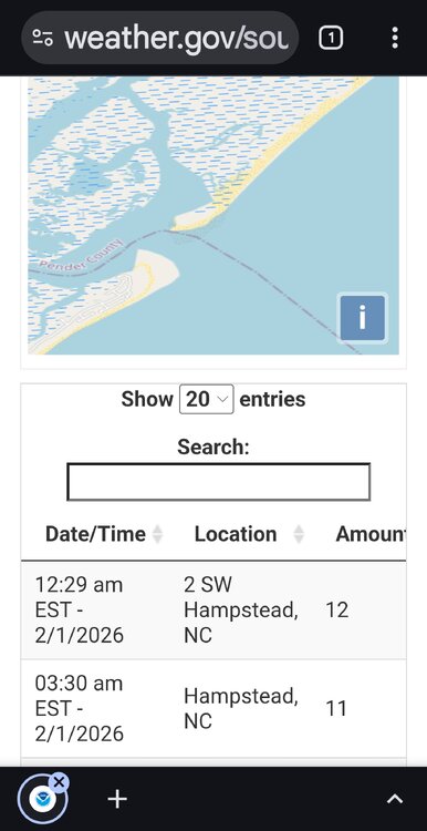
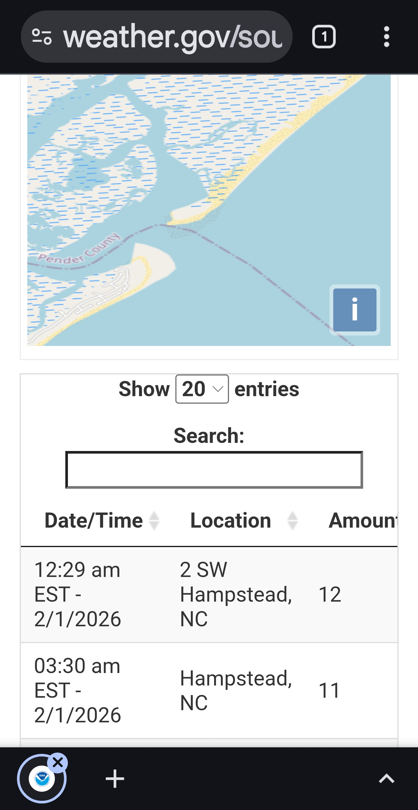
162 NOUS42 KILM 011137 PNSILM NCZ087-096-099-105>110-SCZ017-023-024-032-033-039-053>056-012337- Public Information Statement Spotter Reports National Weather Service Wilmington NC 637 AM EST Sun Feb 01 2026 The following are unofficial observations taken during the past 6 hours for the storm that has been affecting our region. Appreciation is extended to highway departments, cooperative observers, Skywarn spotters and media for these reports. This summary also is available on our home page at weather.gov/ilm ***********STORM TOTAL SNOWFALL (AT LEAST 2 INCH)*********** LOCATION TOTAL TIME/DATE COMMENTS SNOWFALL MEASURED (inches) NORTH CAROLINA ...Bladen County... White Lake 6.0 542 AM 2/01 Public 5 E Tar Heel 5.0 428 AM 2/01 White Oak ...Brunswick County... Ocean Isle Beach 15.0 540 AM 2/01 Public Longwood 14.0 515 AM 2/01 Public 1 NW Ocean Isle Beac 12.0 443 AM 2/01 Public Calabash 8.5 1241 AM 2/01 Public Southport 8.0 544 AM 2/01 Public Bolivia 6.0 115 AM 2/01 Public Leland 5.0 521 AM 2/01 Public ...Columbus County... Cerro Gordo 14.0 557 AM 2/01 Public Tabor City 14.0 522 AM 2/01 Public Whiteville 11.0 200 AM 2/01 Public Clarendon 8.5 1248 AM 2/01 Public Evergreen 7.0 1241 AM 2/01 Public 5 W Lake Waccamaw 6.5 1239 AM 2/01 Hallsboro 2 NW Whiteville 6.0 1239 AM 2/01 Public ...New Hanover County... 1 ESE Wrightsboro 3.4 100 AM 2/01 NWS Wilmington ...Pender County... 2 NNW Hampstead 12.0 430 AM 2/01 Castle Bay Hampstead 11.0 330 AM 2/01 Public 2 NNW Topsail Beach 9.5 118 AM 2/01 NWS Employee ...Robeson County... Lumberton 12.0 550 AM 2/01 Public 4 SE Lumberton 10.5 202 AM 2/01 Public 7 NE Orrum 9.0 121 AM 2/01 Burnt Islands community Fairmont 9.0 212 AM 2/01 Public Orrum 8.0 123 AM 2/01 Public Pembroke 7.5 215 AM 2/01 Public SOUTH CAROLINA ...Darlington County... North Hartsville 7.0 149 AM 2/01 Public ...Dillon County... Lake View 12.0 555 AM 2/01 Public 3 SW Little Rock 7.0 115 AM 2/01 Public Dillon 7.0 201 AM 2/01 Public 2 SSW South Of The B 5.0 113 AM 2/01 Hamer community ...Florence County... 2 W Florence 8.0 256 AM 2/01 Public Florence 6.0 606 AM 2/01 Public ...Georgetown County... Murrells Inlet 5.5 300 AM 2/01 Public ...Horry County... North Myrtle Beach 8.0 548 AM 2/01 Public Loris 7.0 320 AM 2/01 Public Little River 5.5 208 AM 2/01 Public Conway 5.0 1253 AM 2/01 Public Galivants Ferry 5.0 131 AM 2/01 Public 3 SW Myrtle Beach 5.0 209 AM 2/01 Market Common Surfside Beach 2.5 118 AM 2/01 Public ...Marlboro County... Wallace 6.0 109 AM 2/01 Public 1 SSE Brownsville 4.0 1258 AM 2/01 Public ...Williamsburg County... Greeleyville 3.0 138 AM 2/01 Public 10 E Trio 3.0 232 AM 2/01 Warsaw community && -
Looks meager and questionable.
-
How? Telling it how it is. Even Will just mentioned it. Gonna have to wait post 10th probably. This cold relaxes big time. Gonna be more marginal cold I think. Euro op even has a cutter as it breaks.
-

Possible coastal storm centered on Feb 1 2026.
Ginx snewx replied to Typhoon Tip's topic in New England
My boy a home grown weenie sent in his report. Just bought a home there. Big surfer