All Activity
- Past hour
-
Nam a torching
-
Can you get sleet from a column with a highest temperature below freezing? Does it depend on actual temperature or potential temperature? How much horizontal shift can there be in falling precip in a winter storm? Can the precip reaching the surface have originated more than a few miles west of where it reached the ground? I would assume it would be 10-15 miles max given wind speeds but I have never studied this detail, has anyone ever studied it? I am interested in what happened in pure physical terms, as I was watching hourly maps of temperatures at 700 and 850 mbs during the sleet phase (in NJ) and it seemed that temps were generally -2 to -4 C at 700 mbs and colder at 850 (and 925) mbs. So does that imply a warmer reading somewhere a little below or above 700 mbs? Or is it possible for sleet to occur from a lower thermal max? (I know what sleet is, that's not the question I am trying to answer, but how and where it forms). Glad to read so many positive outcomes and sad about the negative ones, in hindsight it appears that the GFS miscalculation originated with its track for the surface low, it failed to detect the potential for a double-centered low over w PA with a lingering northern component. As soon as that was absorbed into the southern center (which later transferred to the coastal) the sleet turned back to snow for some parts of n NJ. So I think that was the source of the false snowfall regional depiction at 18-24 hours lead time.
-

Central PA Winter 25/26 Discussion and Obs
Itstrainingtime replied to MAG5035's topic in Upstate New York/Pennsylvania
Loved Penn State's effort today. Satisfying way to end a crazy season. It'll be interesting to see what Ethan decides to do. I'm a fan. -
Can you imagine what a heating bill would look like these days with a mean monthly temp of 25? Have to believe it would cause hardship for many.
-
Love that look. It's the one I was talking about a couple of days ago. It is going to depend if we can get a piece of that pacific energy to eject into the CONUS.
-
Wooo baby there’s some bangers in here
-

Winter 2025-2026 Offers Return to Normalcy
40/70 Benchmark replied to 40/70 Benchmark's topic in New England
Friday-Night Saturday AM Snows Verification Strong Overall Forecast With One Major Exception Failed Hedge Against Data For Best Banding The vast majority of the forecast was very accurate, as can be seen by the juxtaposition of maps below. However, the one glaring fault with the map is unfortunately where it mattered most, which is respect to the all-important best banding. As it turned out, the 6-10" "bonanza area" should have been placed approximately 50-60 miles to the southwest, over the southwestern half of Connecticut, as the consensus of guidance had emphatically signaled. The rest of the forecast was perfect with the exception of the north shore of Massachusetts, where the ocean enhancement did not come to fruition, so 1-3" would have sufficed as opposed to the chosen 2-5" range. But this issue pales in comparison to the aforementioned discrepancy with respect to the erroneous placement of that extremely heavy band that contained snowfall rates of up to 3-4" for a short period of time. Overemphasis Placed on 700MB Warm Front The main forecast premise in Eastern Mass Weather's Final Call yesterday was that guidance was not emphasizing the placement of the 700mb warm front enough as it pertained to where the band of exotically heavy snowfall would materialize. This was obviously crucial since this band ultimately led to major accidents despite a lower holiday volume of traffic. The forecast rationale was that the band would focus where the 700mb warm front stagnated, which was over the upper Connecticut river valley of Massachusetts, much of Worcester county and into the hills of extreme northeastern Connecticut and northwestern Rhode Island. However, the reason that guidance was not targeting this area where the mid level front stagnated, as it would under conventional synoptic circumstances ,is that the dynamics of the system were eroding and being displaced southeast at that point due to the resistance it was met with by the confluent flow to the northeast. This is an issue that the forecast took into account and contemplated when considering the disparity between the ominous forecast soundings over western Connecticut and, the tamer scenario being depicted over Worcester in central Massachusetts. However, Eastern Mass Weather incorrectly took a leap of faith that guidance was eroding the dynamics too quickly, which was the ongoing trend. This would have allowed central Massachusetts to better avail of the stagnating midlevel warm front to endure a protracted period of enhanced snowfall rates, but ultimately these rates occurred instead further to the south, over Connecticut, as the consensus of guidance had been indicating. Final Grade: B- -
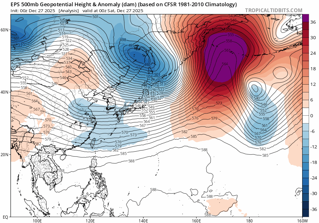
Decent look after the next couple days,you should be looking at a pattern change the next couple days.As this trough passes through Russia/Mongolia,models continue to show rising heights in this region for several days,just get ready for some moderation into the first week of Jan,throughs into Mongolia/Russia mean ridge building into the Koreas,so you should/could be seeing a -PNA for a brief time
-
Wounded Duck Strikes Back: Dec 26 & 27th Winter Storm Obs
40/70 Benchmark replied to WxWatcher007's topic in New England
Great forecast for last night and early this AM, with the notable exception that I missed on the placement of the heaviest band, so amounts were oversold in central Mass, where 2-5" fell instead of the 6-10" forecast fell where models had in CT. Final Grade: B- https://easternmassweather.blogspot.com/2025/12/friday-night-saturday-am-snows.html -
This is not a bad look for a 30 day mean. The NAO is over the Davis Straits. There is an EPO ridge. BN temps over the northern half of the East with cold centered just a bit to our NE. The Weeklies have been shaky lately so I hesitate to share, but hey…
-
Verification scores?
-

Winter cancelled/uncancelled banter 25/26
North and West replied to Rjay's topic in New York City Metro
[emoji817] Key here is normie, and honestly, they’re not wrong. (I know we can argue semantics, but if you promise me steak and give me hamburger, well…) . -
Winter cancelled/uncancelled banter 25/26
North and West replied to Rjay's topic in New York City Metro
I hope he’s ok. He posted a lot but wasn’t mean. . -
Oof, bad trend the past 24 hours. Half the models now show Denver getting skunked. Some still show 1-2".
-
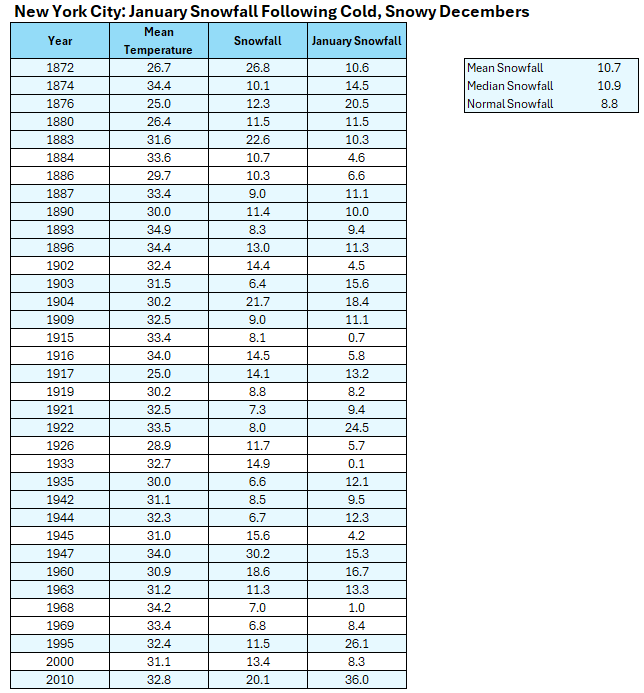
1917 also had a mean temperature of 25.0° for December Corrected Table: Note: The initial table was constructed from summing daily snowfall amounts. Not all daily amounts are in the NYC climate record. Thus, doing so understates the monthly figures. Here's the correct table using the monthly figures.
-
Usually it’s the other way around though. We’re usually looking good and then out of nowhere that f***ing GL Low will appear like clockwork.
-
Looks good. Liking the 0.25 contour cutting through DAW. Another case where Rochester has a lot more icing risk than my hood just 10 miles SE. I could see DAW getting 0.25” but my backyard getting less than 0.1”. We’ve had a number of events with very favorable atmospheric icing conditions but a degree or less saves us from disaster. Not the case just 5 miles to my northwest…
-
 As I've said all along, 80 and sunny doesn't seem so bad after all.
 -
I have been comparing operational to ensembles for a long time. The ensembles have often been too bullish on precip. for Augusta that never materialized. Too many opinions. AI may be the trend for the future, but again, the AI ensemble snow prediction was nuts not long ago.
-
That warm nose progresses north pretty quickly so yeah, Maybe 1-3" or so for you, Maybe 1" here.
-
We warm for a little Monday but we may have a glacier on our hands next week.
-
 January! DCA _ NYC _ BOS _ ORD _ ATL _ IAH _ DEN _ PHX _ SEA 1.0 1.0 0.5 0.5 1.5 1.5 0.5 1.0 0.5
 -
We also had 25 mean temp in Dec 1989, but then we had 40-41 mean temps in Jan and Feb (1990), and 46 mean temp in March.
-
Yes, the La Niña cases were snowier.
-
I'm hoping for 3-5 inches of snow/sleet before the flip to freezing rain and we'd be mint. However I think it's going to be more like 1-2