All Activity
- Past hour
-
-

January 2026 Medium/Long Range Discussion
SomeguyfromTakomaPark replied to snowfan's topic in Mid Atlantic
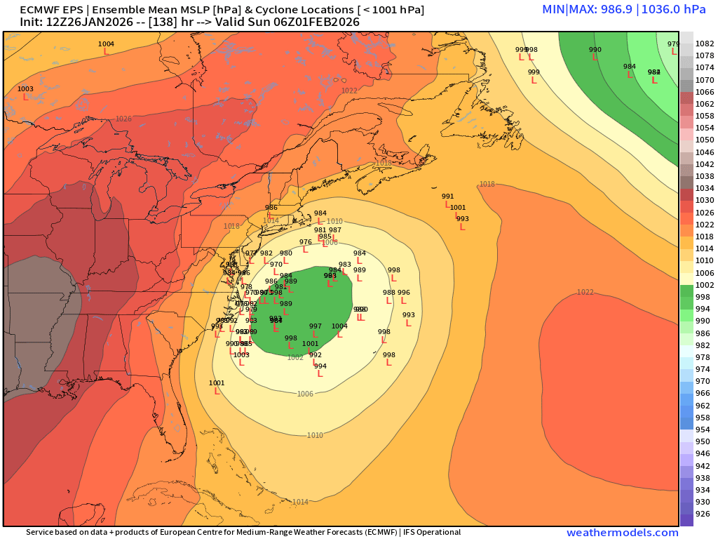
At 138 the EPS has a lotta members that would work for us. -
Just like with yesterday with the amount of cold air in place I'd rather take that chance than have it whiff to the east and everyone gets nothing.
-
Past storm was a different setup synoptically tho wasnt it? I am not hedging any bets regardless.
-
-

The “I bring the mojo” Jan 30-Feb 1 potential winter storm
olafminesaw replied to lilj4425's topic in Southeastern States
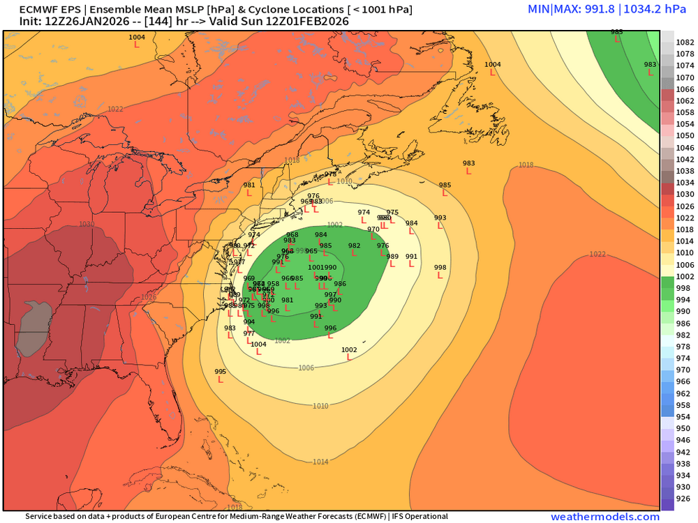
EPS more suppressed, but in a great spot for the coast -
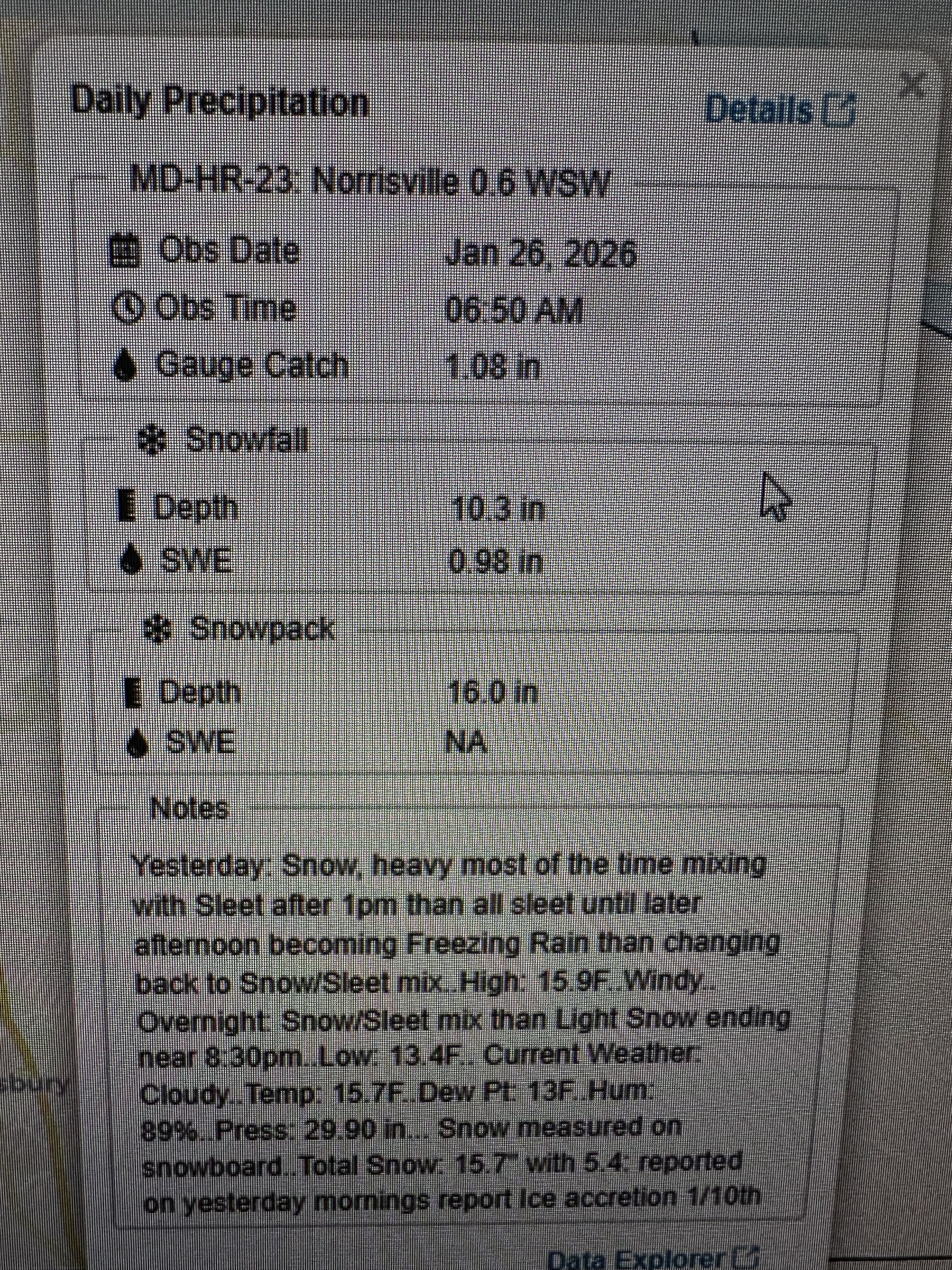
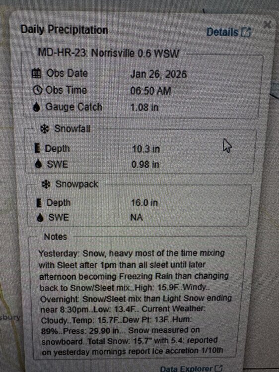
lol @WxUSAF 10.3 depth?? also, the weather notes from yesterday: no way they didn’t flip to sleet until 1pm. I was sleeting by 10am
-
Can’t wait to see this place at the end of the week
-
January 2026 Medium/Long Range Discussion
SomeguyfromTakomaPark replied to snowfan's topic in Mid Atlantic
EPS looking good to me so far (90 hours) but also I am not very intelligent. -
I'm hoping the Google AI model doesn't move SE. It's been steady with at least 2-4 inches for more of the area, and 4-8 for parts.
-
Much better than the op
-

January 2026 Medium/Long Range Discussion
RevWarReenactor replied to snowfan's topic in Mid Atlantic
No, check out the January 2022 blizzard for more. Perhaps you don't remember it because there isn't much to remember for these parts. But in summary Atlantic City got 16 inches while we watched. -
 Another inch or two new came out of that. Up to 17", but like you said the 15+" was measured at the end not 6 hourly
 -

Southern MD / Lower Eastern Shore weather discussion
AlexD1990 replied to PrinceFrederickWx's topic in Mid Atlantic
Feeling good about where this part of the subforum sits. Will be interesting to see how model trends play out over the next few days. -

The “I bring the mojo” Jan 30-Feb 1 potential winter storm
BornAgain13 replied to lilj4425's topic in Southeastern States
Totals were still big for NC but not further north. -
 Congrats on the jack when all is said and done.
 -
 2 weeks ago I was posting to my clients about the ghost of Jan 2015 walking through the door! Well, he's now sitting at the kitchen table! Great storm... Last week Will posted about the Gulf opening up (moisture flow) and how that tends to mean northward trends! I have been waiting for the gulf and deep southern moisture to get involved for years!!! Let's see if we can keep it going with East Coast action.
 -
 This even is comparably to only two other storms since I moved to Methuen in October 2018, that being December 1-3, 2019, and January 7, 2024; however, both of those systems melted fairly rapidly with sustained warmth imminently on the horizon. This most assuredly looks to be the most impressive stretch of winter since moving here given that warmth is nowhere in site at this time-The SNE snow drought is dead...rejoice.
 -
 Up to 9.2”. Still with good growth -SN.
 -
I think when we see partial phases...they just don't get worked out really well until inside of 3-4 days. I do think this looks more like a Carolina special. My investment level is low, but think light snow is possible with this for NE TN and SW VA. I am not even sure the northern stream energy is even being modeled correctly. Preferably, we would like that negative tilt maybe 150 miles further west in Georgia. But that phase is so finesse...just tough to know. I would feel good if I lived in the Piedmont, and keep an eye on it if in NE TN. NE TN may well score w/ the northern stream energy before it phases, catch a little bit of backing, and see some light snow as a result. But as we have seen this winter...these things do change quickly from time to time. Of note, there are a lot of small pieces of energy directly behind this. JB noted last night, and I tend to agree, this looks like a lot of lighter events until after Feb 10, and then the STJ fires again w/ cold in place.
-
Yeah. Niñas are known for coastal scrapers and CAPE to Nantucket specials. But it’s also a huge over generalization to say it’ll fail because it’s a niña.
-
 about a inch new since the snow started back up this morning
 -
Cue the reasons why it can't possibly cut...or come WAY north..........
-
There’ll always be the kicker shortwaves we have to look for these days but at this point it’s way too far out to be determined.
-
12.2" was my total with 1.8" of it being sleet. I agree that 15.3" reading is a little high IMO.