All Activity
- Past hour
-

E PA/NJ/DE Winter 2025-26 Obs/Discussion
zenmsav6810 replied to LVblizzard's topic in Philadelphia Region
What does the Euro ens say? -

Winter 2025-26 Medium/Long Range Discussion
mimillman replied to michsnowfreak's topic in Lakes/Ohio Valley
The main focus during the end of the week and into the upcoming weekend remains on the potential for another round of accumulating lake effect snow (potentially a long-duration event) as another sprawling ~1050 mb arctic high descends out of Saskatchewan and Manitoba late Thursday night into Friday. As this occurs, 850 mb temperatures are forecast to drop to around minus 20 C, which in turn will result in building inversion heights over the lake. LES parameters certainly look sufficient to support periods of more intense lake effect snow, with lake- induced ELs nearing 9-10 kft at times, especially through Friday with 850 mb temps forecast to warm through Saturday. Initial LES looks to develop late Thursday night into early Friday morning. It`s possible that this initial activity has a somewhat difficult time organizing given some degree of wind shear in the boundary layer as a synoptic scale trough pivots southwest out of the Upper Great Lakes. By later Friday night and Saturday, however, guidance depicts generally lessening shear as the bulk of the atmospheric flow shifts northeasterly. Guidance then depicts LES organizing into a single dominant band during this time as low-level convergence maximizes down the long axis of the lake. During this time, ELs are forecast to fall a bit as 850 mb temps warm, which may have a bit of a modulating effect on LES intensity. That said, given the progged increasing convergence, even 6-7 kft ELs will be more than sufficient to support periods of heavier snowfall. At this point, it remains too early to hone in on specifics, but guidance trends continue towards an impactful period of lake effect snow in our area, including Chicago, parts of NE and east-central Illinois, and NW Indiana from late Thursday night through Saturday night, and possibly even through Sunday. Guidance at this time does indicate the potential for quite a bit of band wobbling, which in turn could limit residence times and overall totals, but a more quasistationary north-south oriented band is also advertised (CMC, UKMET for example). Temperatures in the teens and single digits will have the potential to exacerbate impacts due to a very light/fluffy snow and lessened effectiveness of road treatments. -

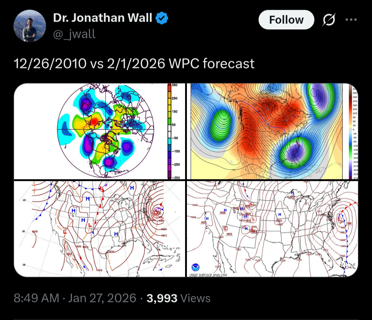
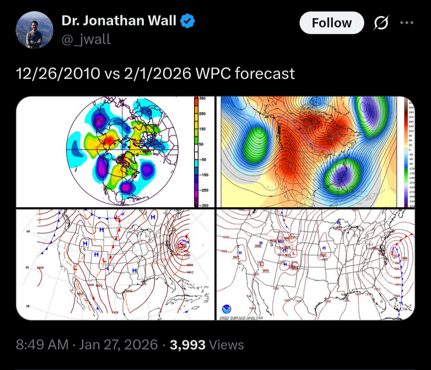
Possible coastal storm centered on Feb 1 2026.
weatherwiz replied to Typhoon Tip's topic in New England
Also, the size of that high pressure system is massive, stretching from the upper-Midwest into southeast Canada southwest into the southern Plains...that as well argue for something farther north and west for track -

The “I bring the mojo” Jan 30-Feb 1 potential winter storm
olafminesaw replied to lilj4425's topic in Southeastern States
-

Possible coastal storm centered on Feb 1 2026.
dryslot replied to Typhoon Tip's topic in New England
Just was going to post that until i just saw this, But i agree, We need to wait a couple more days at the very least for this to show its hand, It could end up being at least an eastern special. -
For the last storm, all models shifted south before shifting north—waaay north
-
Low of 12.7
-
But seriously, it looks bleak. But I'm hanging in there for a bit. The chances of a comeback dwindle with each new set of runs at this point and I hate to say this, I get the gloom in here, but I think we should slow down and give it another run or two.
-
Thing is the northern stream is sitting in S Canada right now. It isn’t like this is energy coming off the PAC and poorly sampled. Not saying it can’t happen, but I don’t expect any type of giant shifts personally. I hope I’m wrong though.
-

The “I bring the mojo” Jan 30-Feb 1 potential winter storm
SnowDawg replied to lilj4425's topic in Southeastern States
Definitely gonna need more moisture back this way than the Euro showed not to just lose all of it to virga given how dry the initial airmass is going to be. -
Lol yea mine isn’t sharp, but def stiff. Think a lunchtime stretch is incoming.
-
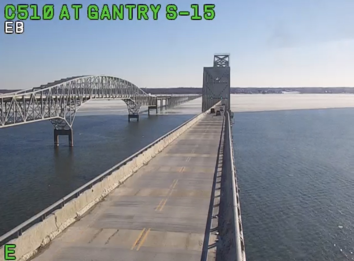
Winds definitely stayed up last night and prevented the low single digits in most places. Those that did go calm got to the advertised 5 deg-ish fairly easily. Look at all the ice that got pushed to the east side of the bay yesterday to Kent Island.

-
Possible coastal storm centered on Feb 1 2026.
weatherwiz replied to Typhoon Tip's topic in New England
Yup...this is a model weakness in these airmasses. Forecast models don't have the necessary resolution to accurately handle this so you'll see the models just want to put the low where the warm air is. We certainly can't rule out a dual low structure either and there is a chance that this system has more in the way of convection associated with it which adds additional problems (as we know) -
Start the thread!
-
My storm total + the lake effect yesterday is 13". The lake effect was a nice surprise that helped boost the numbers. Back to snow again today, getting deep out there. I have 20" on my deck. Hoping to make a run at 24" as that would be the most since I've lived here.
-

Arctic Hounds Unleashed: Long Duration Late January Cold Snap
Brewbeer replied to WxWatcher007's topic in New England
I turned my boiler's circulater pump up a notch -
Yeah looks to be a midpoint solution between GFS and EURO operational. Long range NAM like you mentioned though.
-
As a certified IMBY snow weenie, of course I want this to happen. I just don’t have that fuzzy feeling yet.
-

Possible coastal storm centered on Feb 1 2026.
Typhoon Tip replied to Typhoon Tip's topic in New England
just using your chart here... yeah, it's almost to the point of frustration that the models appear to be disconnecting the wave -space arguments in their physical result/processing. That ridge being over Idaho ...if anything that presupposes a position near WV with that tough axis.. which would probably parlay quite favorably. That's a bizarrely stretched looking gunk L/W filled with distractions... -

The “I bring the mojo” Jan 30-Feb 1 potential winter storm
BornAgain13 replied to lilj4425's topic in Southeastern States
Consider me not smart lol -

The “I bring the mojo” Jan 30-Feb 1 potential winter storm
Orange county replied to lilj4425's topic in Southeastern States
Seems to me in the last 40 years we have gotten 3-4 inches out of a ULL-maybe once ? -
Who would be the statisticians if that role was given out?
-

Possible coastal storm centered on Feb 1 2026.
Spaizzo replied to Typhoon Tip's topic in New England
That was the case last storm too, no? . -
Possible coastal storm centered on Feb 1 2026.
dryslot replied to Typhoon Tip's topic in New England
Your getting both of those pinwheeling to the NNE, Lot of these models have this dual low structure, Models struggling to where to place the low at the surface off the coast. -
thank god you're here. please have your boyfriend hit him with his umbrella.