All Activity
- Past hour
-
That seems to lock in the cold behind it for the weekend system
-

Pittsburgh/Western PA WINTER ‘25/‘26
colonel717 replied to Burghblizz's topic in Upstate New York/Pennsylvania
This one is in the bag... Time to focus on reeling in next weekend potential. We will most likely be a western edge hit if anything. I wonder how the snow pack after this storm will affect the next one. How will snow pack baroclinic zone set up. -

1/24-1/25 Major Winter Storm - S. IL, IN, and OH
Jackstraw replied to A-L-E-K's topic in Lakes/Ohio Valley
`Still think my call for 7 is still in play. Chance of hitting double digits have diminished some but getting close to a nowcast and subtle changes in QPF can make a BIG difference with these SLR's approaching 25-1, especially on the N/NW side. As OHWeather pointed out the drivers the limiter on "our" side of this thing is going to be how long it takes the DGZ and that dry NE flow at the surface to get juiced and the amount of forcing we can get before it shunts E. As a note, not in our forum but I have a lot of connections in the NC mnt's. A lot of focus has been on deep south ice but I cannot emphasize enough how much more devastating ice in the those mnts just due to limited infrastructure and emergency access. I have been watching the models and every 25-50 years we get a setup like this that could be setting up for the NC/SC mnts. More and more its looking like a strong CAD trapped on the eastern slopes setting up a wedge where the surface low, instead of shunting E through the Chattanooga plateau where they usually do in winter (sad for us), and instead is going to ride up to the Shenandoah valley and shunt E (better for us) there. When this happens you have that warm moist area lifting over the mnts and falling down through that CAD as freezing rain. The setup has to be perfect and this one is as you can see it in the contour fields on the surface maps. Ice storms of this ones potential magnitude there can shut the mnts down for MONTHS. The locals there that have been there a long time are very aware of the devastation a massive ice storm can bring in the mnt's. They actually fear those more than a flooding hurricane remnant. I've seen it myself and it looks like an area the size of Vermont was hit by a bomb. Sorry for the off topic but a lot of concern for them right now. -
 Qpf cut on gfs moving to euro
 -
GFS H5 map has players on the field for next potential...let's see where it goes
-

Possible Record Breaking Cold + Snow Sunday 1/25 - Tuesday 1/27
Stormlover74 replied to TriPol's topic in New York City Metro
Ukie held serve i guess. Its a mess...drier and has snow to Delaware with 552 thickness -

January 25-26 Winter Storm Potential
CoolHandMike replied to Ralph Wiggum's topic in Philadelphia Region
What NAM are you guys looking at? Still seeing double digits region-wide over at TT... What am I missing? -

Jan 24-26 Weekend Snow and Sleetfest Model Thread Part Tres
balltermen replied to H2O's topic in Mid Atlantic
The GFS has trouble with east coast snowstorms. especially with a tricky northern stream Some people have drawn similarities to 2/12/14. The GFS wasn't on board until like 12 hours out. Which is to say. i think its too cold -
 URGENT WEATHER STATEMENTNATIONAL WEATHER SERVICE – WINTER DISAPPOINTMENT DESKISSUED: Immediately, because hope is fragileSUMMARY:A significant winter storm is expected to impact the region. Forecast confidence remains high for heavy snow potential, followed by a dangerous transition to sleet, freezing rain, or the ultimate betrayal: plain rain.⸻HAZARDS:• Initial excitement from model runs showing 18–30 inches• Rapid emotional destabilization as warm nose appears• Keyboard smashing, doom posting, and refresh-induced psychosis• Statements such as “this storm is dead” at T-72 hours⸻SUICIDE WATCH (METEOROLOGICAL): IN EFFECTA Snowlover Emotional Crisis Watch is in effect for the duration of the event.Residents are advised:• Do not do anything rash based on one model run• Step away from social media during the sleet phase• Remember: one band can still save the storm• Refrain from declaring winter “over” before March⸻TIMING:• Snow: Hope Phase• Sleet/Freezing Rain: Anger Phase• Rain: Acceptance (or complete meltdown)• Post-storm: “Next system looks promising” Phase⸻PRECAUTIONARY/PREPAREDNESS ACTIONS:• Touch grass (or snow, if available)• Hydrate• Do not fight family members over 850 mb temps• Seek professional help if you start trusting the GFS blindly⸻FORECAST CONFIDENCE:Low on precipitation typeHigh on emotional damage
 -
Not that. Comes in from PA. Can see it on MSLP and 700 VV.
-
(002).thumb.png.6e3d9d46bca5fe41aab7a74871dd8af8.png)
January 25-26 Winter Storm Potential
ChescoWx replied to Ralph Wiggum's topic in Philadelphia Region
Above is only thru 1pm -

January 24-26: Miracle or Mirage JV/Banter Thread!
Rvarookie replied to SnowenOutThere's topic in Mid Atlantic
Profile pic checks out. No wonder why you see what others don’t. Enjoy the trip my guy -

Possible Record Breaking Cold + Snow Sunday 1/25 - Tuesday 1/27
MarcmmKU replied to TriPol's topic in New York City Metro
and yet Florida pulls a 10" right down to the beaches. We are so effing cursed lmfaooo -

“Cory’s in LA! Let’s MECS!” Jan. 24-26 Disco
WxWatcher007 replied to TheSnowman's topic in New England
Where do you get that plot from again? -

1/24-1/25 Major Winter Storm - S. IL, IN, and OH
HillsdaleMIWeather replied to A-L-E-K's topic in Lakes/Ohio Valley
GFS went southeast, NAM went northwest. Man I miss the days of having what felt like good models. -

Jan 24-26 Weekend Snow and Sleetfest Model Thread Part Tres
mitchnick replied to H2O's topic in Mid Atlantic
Longer range Rap currently updating is colder and wetter. Of course, there's the range issue, but it's better than warmer/dryer. -

“Cory’s in LA! Let’s MECS!” Jan. 24-26 Disco
Southshorewx replied to TheSnowman's topic in New England
They dont care. Once you get up to those ranges schools are closed and travel is hazardous. They could put 10+ everywhere and they are covered. -
Interesting. I was looking at 13z vs. 20z and looking at total precip 20z looks juicier.
-

“Cory’s in LA! Let’s MECS!” Jan. 24-26 Disco
Ginx snewx replied to TheSnowman's topic in New England
What? Don't fall for the trap. All systems go. -

January 25-26 Winter Storm Potential
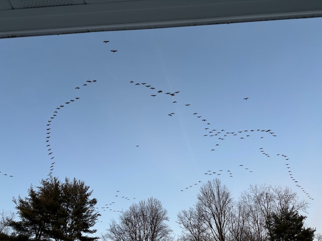
Physicsteve replied to Ralph Wiggum's topic in Philadelphia Region
The CGI (canadian goose index) just rocketed off the charts here. Must have had 300 or so just go overhead and i hear more coming. Couldnt ask them in time if they thought the warm nose was being over-modeled though. Still have to wait and see.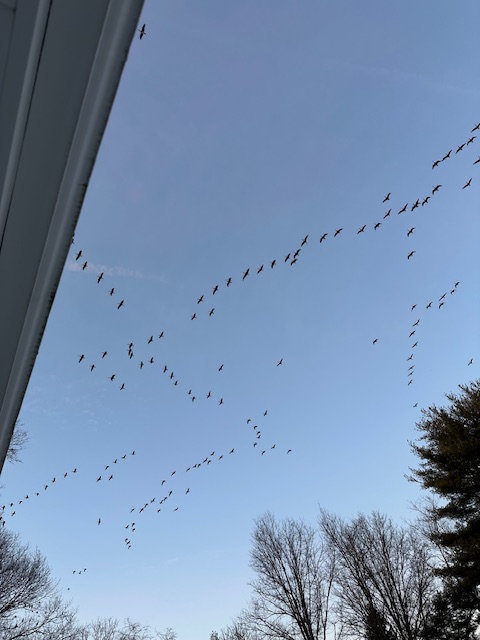
-
Certainly the quicker we can get precip into NC, the greater the snow chances will be. At the same time, the dew points will be so low Sat evening, its hard to imagine any precip actually making it to the surface.
-

Jan 24-26 Weekend Snow and Sleetfest Model Thread Part Tres
snowfan replied to H2O's topic in Mid Atlantic
Out of the area but related to the cold air funneling in.....wind chills tmrw for KMWN are going to approach -90. -

Central PA Winter 25/26 Discussion and Obs
Mount Joy Snowman replied to MAG5035's topic in Upstate New York/Pennsylvania
GFS mostly holds serve but does bring the sleet line a wee bit further north. It's that 800-750mb layer that always kills us. Need the big thump before any worries arrive. -
Quickly catching up, haven't been able to post today... Not sure what to make of the 18z NAM… 18z ICON, RGEM, and GFS held relatively steady in terms of thermals, and Jan 23 19z NBM so far has not flinched though I’m not sure if these models make it in the blend (I do not take these NBM forecasts literally): So we watch for elevated warming nipping at south coast and beyond but remain skeptical unless further support. At worst, looks like heavy thump followed by light sleet / dryslot after bulk of accumulation. More definite takeaway from 12z-18z suite today is less promising coastal cyclogenesis CCB potential for Monday. By 18z Monday, flow at 925-850 becomes more northerly and dries out (corresponding to closing lows further northeast) on all guidance, whereas in prior runs (again, 0z ICON from 1/22 being the best depiction with easterly fetch beyond 18z Monday (with closed 925-850 low south of LI). It's 60+ hrs out so arguably that’s still in play, but it’s looking less likely.
-

Jan 24-26 Weekend Snow and Sleetfest Model Thread Part Tres
JenkinsJinkies replied to H2O's topic in Mid Atlantic
18z and still no cave? Papers are going to be written about this…