All Activity
- Past hour
-
Better to be in the game than not. We have a pattern that looks conducive to snow vs a shit the blinds pattern. Let’s hope we have a lot of sleepless nights next month (from tracking storms vs utter depression from warm temps/rain ).
-
Good start.
-
Could be the 6th onwards. All the ensembles have signals. Suppression can be an issue but hopefully we all cash in.
-
AI has too many pieces not complementing each other
-

E PA/NJ/DE Winter 2025-26 Obs/Discussion
RedSky replied to LVblizzard's topic in Philadelphia Region
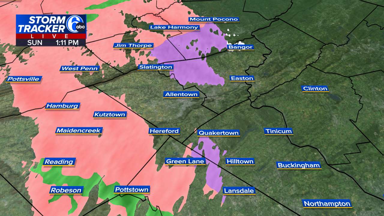
Allentown to date is -6.6F December of yore -

January 2026 Medium/Long Range Discussion
SomeguyfromTakomaPark replied to snowfan's topic in Mid Atlantic
The last few years we have seen the good looks on the models like this and they’ve been head fakes, or they disappear after brief non producing period. Let’s see if we can actually cash one in. -

January 2026 regional war/obs/disco thread
UnitedWx replied to Baroclinic Zone's topic in New England
Well here, not excited for it showing snow... just nice to see a POSSIBLE better pattern than we've seen in a while. What a clam -
Nice catch with the eagle!
-
the EURO AI just took 18 inches away
-
We dont need a ton of patience this year. We've already discussed this in the other sub, please keep up Next line is "buckle up", which we are teetering on attm.
-
just be patient Howard
-
I would kill to be by Lake Superior in the UP for this one. What an incredible blizzard it will be. Heading up there in mid Feb so at least a good base is being laid!
-
The next line will be staying patient.
-
Just gotta avoid the infamous delay pattern onset . Right now it looks like 1/7-1/10. If that starts to become 1/15 then 1/20 then we are underway with a problem once again
-
I think Jan 8-14 will be the window.
-
We might have to deal with a cutter to set up the pattern
.thumb.png.2093493a7411d76d9496bee1e141690e.png)
-
Tomer Burg @burgwx · 1h What does this mean for snowstorm prospects in the East Coast? Initially, not much. Notice how we start with the same cold and dry NW flow regime we've been in before. The key is to monitor the upstream evolution, as the Bering Sea block erodes and is likely replaced by a Pacific trough, increasing the chances of western US ridge amplification. The kind of pattern increases the probability of a moderate to major snowstorm vs. climatology in the Mid Atlantic, and potentially southern New England, which would necessitate a well-timed upstream ridge amplification coinciding with downstream confluent flow and a sufficiently cold airmass in the northeast US. While a major snowstorm is never a guarantee, chances of at least one or two in the January 8-25 time frame are higher than average
-
Now that you bring that up I do remember that about the depth. Couldn't remember if it was from big dogs or just back to back great storms (we spent 2 straight months in 2014 between 14-21" depth with the biggest single storm 11"). Being the climo guy its so easy for me to look up anyone's data in the US, but Canada is way more difficult. I have an environment Canada bookmark, as im other interested in peaking at Windsor or Toronto, but its definitely nowhere near as user friendly as the NWS. And yeah they hand out advisories like candy in lower MI lol.
-

E PA/NJ/DE Winter 2025-26 Obs/Discussion
Birds~69 replied to LVblizzard's topic in Philadelphia Region
32F/DP 26F
-
The issue isn't that the pattern isn't blocky as shown by this ridiculous 500mb map But instead that the southern shortwave which delivers our storm is just barely captured and amplified by the northern ULL. We are genuinely like 12 hours away from a complete nuclear capture scenario with the displaced ULL and the southern energy fully phasing instead of just helping it gain latitude. I mean just look at how close we get to greatness. Though arguably the best part about the Euro run is that even after this storm we are still in a great pattern. We lose the Atlantic a bit but still have a great EPO and PNA with an active southern stream. Would be a fun time and great to see the pattern reflected in the OPs.
-
I looked at the NYC snowfall for the 17 -ENSO winters for which Dec was cold and had snowfall of 6”+ (from @donsutherland1updated list): Year (Dec)..Total Season..Jan+ 1872….60.2….29.9 1874….56.4….46.3 1886….31.9….21.6 1893….39.2….30.9 1903….32.4….26.0 1909….27.2….17.4 1915….50.7….42.6 1916….50.7….36.2 1917….34.5….20.1 1922….60.4….51.4 1926….22.3….10.6 1933….52.0….36.6 1942….29.5….21.0 1944….27.1….20.4 1995….75.6….61.2 2000….35.0….21.6 2010….61.9….41.8 ———————— Analysis: -AVG of these Jan+: 31.5” vs 22.1” full 156 year record mean or 143% of mean for Jan+ (median was 29.9”) -41% (7 of 17) had 35”+ for Jan+ vs only 12% of the other 139 (17 of 139) -These 17, which are only 11% of the total 156 on record, had: 1. Highest Jan of the 156 on record (2011’s 36.0”) and 3 of top 5 Jans (2011, 1996, 1923) 2. 3rd highest Feb of the 156 (1934’s 27.9”) 3. 2nd highest Mar of the 156 (2016’s 25.5”) 4. Highest Apr of the 156 (1875’s 13.5”) and tie for 5th (1917’s 6.5”) ————————— My NYC total 2025-6 snow prediction based on these stats: 40” (most likely range 30-50”) This compares to 156 year and 35 year means of 28”.
-
4.0-8.0
-
The last frame of that animation is absolutely the setup we get our big dogs. Displaced PV with a huge block overtop. And the west coast ridge in perfect position for us to score. We just have to hope that map is correct.
-
LETS GO BROWNS
-
Never EVER change, Ji. lol


.png.6baaaee864a8b10d6273ca6402df08c8.png)