All Activity
- Past hour
-
 This will be bad for Merrit and 95
 -
 Yes just hope it doesn’t back build or train, Trumbull area might get some training.
 -
 Fortunately moving along…slowly…
 -

Pittsburgh PA Summer 2026 Thread
SteelCity87 replied to TheClimateChanger's topic in Upstate New York/Pennsylvania
That's every year. I love severe weather but it's a bit more spontaneous and doesn't create the hype and discussion that a potential snowstorm does. Today was pretty over hyped for something that didn't even warrant a watch. -
3-4 inches of rain here
-

E PA/NJ/DE Summer 2026 Obs/Discussion
RedSky replied to PhiEaglesfan712's topic in Philadelphia Region
Yeah round one is non existent it's all on round #2 -

E PA/NJ/DE Summer 2026 Obs/Discussion
LVblizzard replied to PhiEaglesfan712's topic in Philadelphia Region
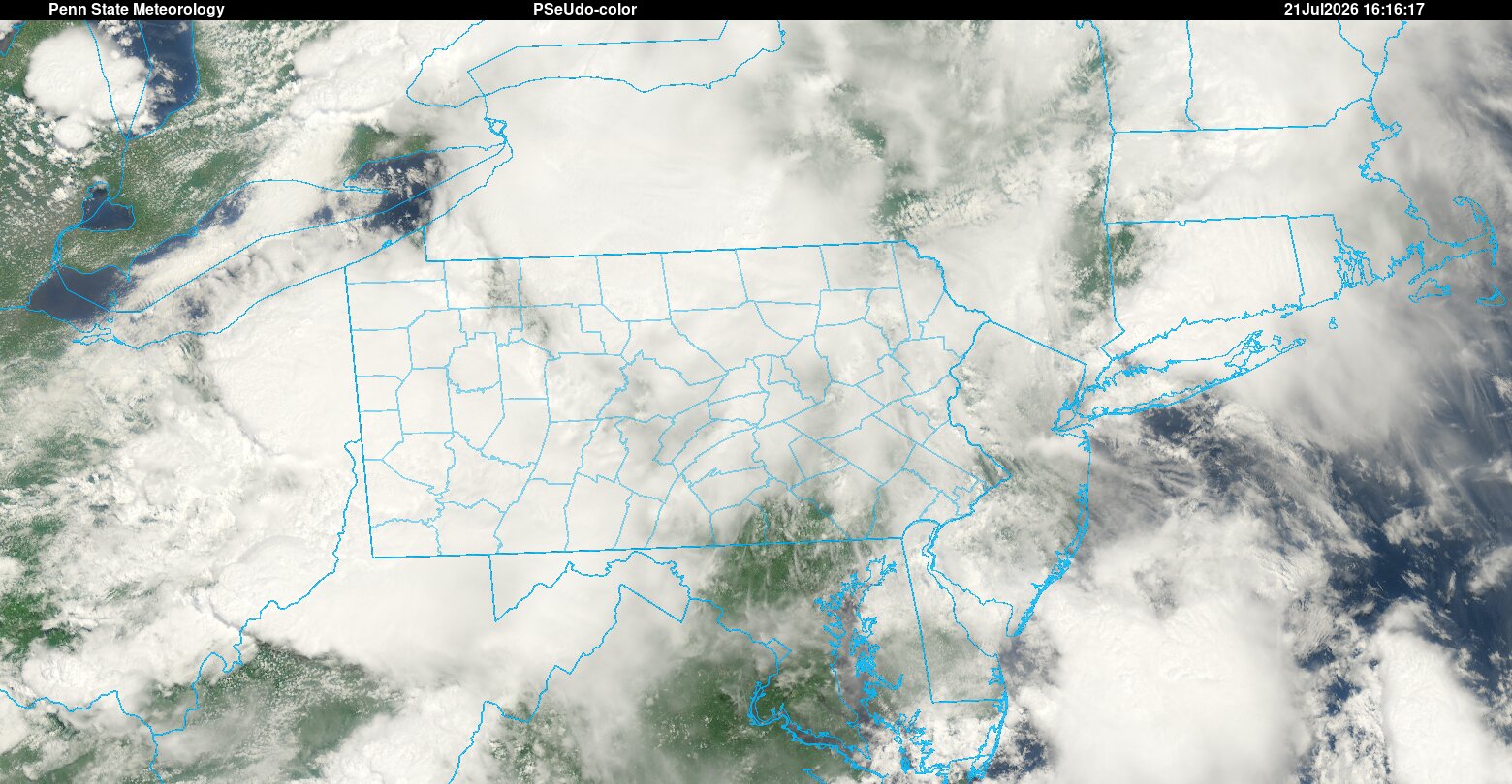
Some clearing is showing up in southern PA and expanding ENE. Today is still game on from the Lehigh Valley southward.
-
Radar looks just like 2024
-
heavy rains here
-
Ugly stuff in SW CT
-
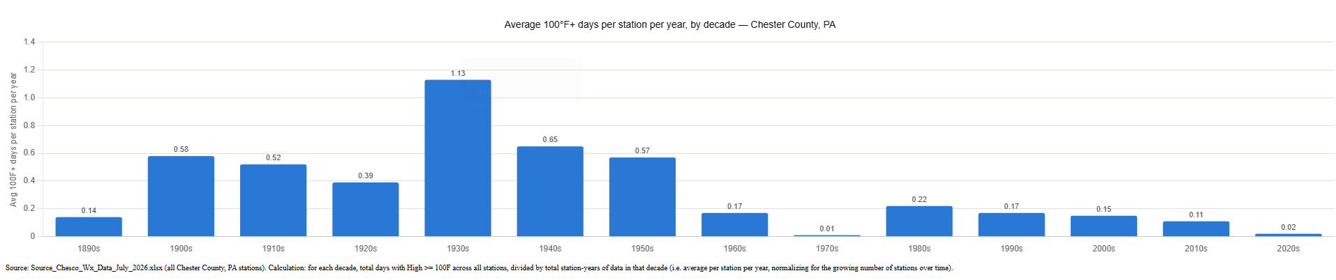
(002).thumb.png.6e3d9d46bca5fe41aab7a74871dd8af8.png) A member asked for an analysis of 100 degree days by decade since the 1890's. This is normalized as days per station per year (total 100°F+ days across all stations in a decade, divided by the number of station-years of data in that decade) rather than a raw sum — otherwise a decade with 22 stations would look "hotter" than a decade with 4 stations just from having more thermometers out there, which would be misleading. The pattern holds up clearly at the county level, same as it did for individual stations: the 1930s stand out sharply at about 1.1 days per station per year — nearly double any other decade — consistent with the well-documented Dust Bowl-era heat. From there the rate declines fairly steadily, bottoming out near zero in the 1970s and again in the 2020s (0.01 and 0.02 days/station/year respectively), with the 2000s-2010s sitting in a modest middle range around 0.11–0.15. Worth flagging directly: the two lowest decades in the entire 130-year record are the 1970s and the current 2020s — and the current decade of the 2020s (partial decade).
A member asked for an analysis of 100 degree days by decade since the 1890's. This is normalized as days per station per year (total 100°F+ days across all stations in a decade, divided by the number of station-years of data in that decade) rather than a raw sum — otherwise a decade with 22 stations would look "hotter" than a decade with 4 stations just from having more thermometers out there, which would be misleading. The pattern holds up clearly at the county level, same as it did for individual stations: the 1930s stand out sharply at about 1.1 days per station per year — nearly double any other decade — consistent with the well-documented Dust Bowl-era heat. From there the rate declines fairly steadily, bottoming out near zero in the 1970s and again in the 2020s (0.01 and 0.02 days/station/year respectively), with the 2000s-2010s sitting in a modest middle range around 0.11–0.15. Worth flagging directly: the two lowest decades in the entire 130-year record are the 1970s and the current 2020s — and the current decade of the 2020s (partial decade).
-
Atmosphere is a lot more unstable vs the weekend. Severe potential is a lot higher later
-
\ Mesoscale Discussion 1688 NWS Storm Prediction Center Norman OK 1115 AM CDT Tue Jul 21 2026 Areas affected...northeast Kentucky...northern West Virginia...and southern Ohio Concerning...Severe potential...Watch likely Valid 211615Z - 211815Z Probability of Watch Issuance...80 percent SUMMARY...The severe weather threat will increase this afternoon across southern Ohio and northern Kentucky into West Virginia. DISCUSSION...A cluster of storms in southeast Ohio will likely continue east-southeast into a more unstable airmass along a differential heating zone developing across northern West Virginia. Damaging winds will likely be the primary threat with this cluster. Additional storms are expected to strengthen farther southwest through the afternoon with sufficient shear for some supercell structures. Damaging winds will likely be the main threat with this activity with some large hail potential. In addition, a tornado or two is also possible, especially as the low-level jet strengthens this afternoon/evening. A watch will likely be needed within the next 1 to 2 hours to address the threat from the ongoing activity and any additional storms which develop. ..Bentley/Mosier.. 07/21/2026 ...Please see www.spc.noaa.gov for graphic product... ATTN...WFO...CTP...LWX...RNK...PBZ...RLX...JKL...ILN...LMK...
-
 Torrential rain here and rolling thunder but no wind
 -
I topped out at 1.38" after the much smaller second round. In my childhood home in Lafayette - 5 miles as the crow flies, Mom reports 2.5", and she's good with the rain gauge, I taught her well! Zooming in on Weather Underground does show several reports in the low 2s throughout that general area. It's a bummer that Rutgers doesn't have more stations in this area. There is a rather big gap in coverage from the High Point / Vernon / Sandyston area down to Central Morris County. There is a station in Lafayette, I drive by it frequently, but it rarely reports anything anymore. Hell, I'll even volunteer to help maintain a couple of them if they put more up.
-
 Ugh, still dealing with residual issues from Saturday and July 7-8. Don’t need any more rain.
 -
Had non stop thunder and strong winds from those systems in nw Bergen County. Minimal rains. Sparta, nj reported 3.31" of rain this morning.
-

2026-2027 Super El Nino
snowman19 replied to Stormchaserchuck1's topic in Weather Forecasting and Discussion
Warm water volume up to +2.65 -
I see the 15z run continues this theme, with storms scattered around throughout the afternoon instead of a break and then a main line for the early evening. Who knows -- these events are difficult to predict. I see on radar more downpours are popping up in eastern PA, so maybe this new idea from the HRRR is going to be correct.
-
E PA/NJ/DE Summer 2026 Obs/Discussion
LVblizzard replied to PhiEaglesfan712's topic in Philadelphia Region
The HRRR has been adamant about this early activity and it still has severe storms around later. I don’t think it fully kills the severe threat…it does make it a little tougher though. -

2026-2027 Super El Nino
PhiEaglesfan712 replied to Stormchaserchuck1's topic in Weather Forecasting and Discussion
Yeah, the connection has been spotty this morning. -
 At least the last two years I was mostly missing them 15 miles to the south. This year eastern MA hasn’t even been in the game
 -
This looks like a coastal storm Snowfall Map
-
Watchi coming soon for KY/OH/WV per MCD just issued... LWX mentioned in WFO list
- 1,248 replies
-
- 1
-

-
- severe
- thunderstorms
- (and 7 more)
-
 It's a good thing there is minimal sfc instability or at the least sfc parcels aren't getting to the LFC. Also, thats some pretty hefty ZDR values around Monroe to Seymour to Oxford...definitely some FF concern