All Activity
- Past hour
-

Occasional Thoughts on Climate Change
donsutherland1 replied to donsutherland1's topic in Climate Change
The models caught onto the European heatwave about five days before the event. The lead time wasn't great this time around. -
As far as this weekend's "cool" forecast is concerned, here is a portion of the OKX AFD, 850 temps near 0C: Temperatures return closer to normal for the end of this week into early next week. An upper level low originating in the Arctic and associated surface low drop down to the area late Friday into Saturday. This may lead to some showers for southern CT and Long Island. Much of the guidance has 850 temps near 0C with this feature on Saturday. This is well below normal for this time of year.
-
I am supposed to go about and hour north of bangor to open the camp. GFS says ok. Euro is no. Which one wins for Saturday?
-

2026-2027 Strong/Super El Nino
GaWx replied to Stormchaserchuck1's topic in Weather Forecasting and Discussion
What a sloppy Tweet by Leon Simons! He said: “The Relative Oceanic Niño Index (RONI) forecast mean is now touching 3.5°C!” No, it isn’t. ONI is, not RONI. He then posted the latest ONI, which peaks at ~+3.5C in OND, instead of RONI. RONI actually peaks at ~+2.77C in OND as per this image: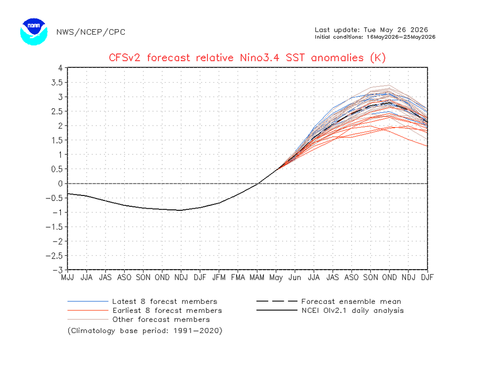
-
Thats an old one. Glad to see it made the winter.
-

Central PA Spring 2026 Discussion/Obs Thread
Itstrainingtime replied to Voyager's topic in Upstate New York/Pennsylvania
MU Weather Center There are no 90°F days on the horizon through the 1st week of June. An "Omega Block" will develop across North America late this week & persist into early June. Persistent, NW flow on the SE side of the block will keep relatively cool conditions in place across the Eastern U.S. -

E PA/NJ/DE Summer 2026 Obs/Discussion
The Iceman replied to PhiEaglesfan712's topic in Philadelphia Region
I don't like to look ahead further than 15-20 days but first half of the month is looking normal maybe slightly below? Unfortunately looks dry as well so even though we got a brief respite from drought conditions. The nino precip anomalies are much more pronounced in the fall and winter months, it could be a few months before the drought truly breaks. -

E PA/NJ/DE Spring 2026 Obs/Discussion
BBasile replied to PhiEaglesfan712's topic in Philadelphia Region
Ended up with 3.01" for the storm total rainfall. Beautiful weather today now that the holiday weekend is over. 76F -
Sun? Never heard of it
-
Yep. Took daughter for a walk and only complaint would be a that a cloud or 3 would have been ok.
-
He needs to be patient. We have 6 months of graupel and 0C 850s awaiting us soon.
-
77.2/57
-
Perfect snoozing wx at night. Crack open all the windows without worry
-
Pouring again here in West Asheville.
-
More moisture building. Rain moving back in.
-
Well, I looked at my modelling method, and it looks like the first half of June will be plagued by CAN HP. In fact, off n on all summer we will be dealing with this scenario. Remember how chilly it got in late Aug of last year? Well I'm expecting the same thing this year with another strong Fall shot after Labor Day. But no worries, there will be some nice, and very warm, stormy conditions in the mix.
- Today
-
Half a foot of rain will do that!
-
Hot day inland with mid 80's yesterday with upper 50's-low 60's near shore. Stms up N produced a good one with a strong hail sig around the Finland/Isabella area down over the Lake. Looks to be about the same today with temps, although a little warmer imby this morning. Was out catching rays this morning while temps hover around 70. Lake breeze not as chilly at my place as it was yesterday. Looks like scattered stms just S of me today.
-

Occasional Thoughts on Climate Change
Typhoon Tip replied to donsutherland1's topic in Climate Change
I recall the 'omega' or omega quasi loading in the models going back 10 days though. The European heatwave,..not so much. -

2026-2027 Strong/Super El Nino
snowman19 replied to Stormchaserchuck1's topic in Weather Forecasting and Discussion
If this is correct, we would smash the current RONI record (1982-83) by an entire degree. It would also smash the traditional ONI record…. -
I actually saw some sun yesterday at my son's baseball tournament in Columbia.
-
ineedweenies is getting that tingly feeling in his nether regions...
-
Right now is pretty close to flawless. If we were to break top 10ing down to the hour, this is a top 1 or 2 hour out of the year right now as we type and read.
-
beautiful and ez on the wallet but pure zzzzzzs