All Activity
- Past hour
-

2026-2027 Super El Nino
LakePaste25 replied to Stormchaserchuck1's topic in Weather Forecasting and Discussion
Not to mention, -PDO usually works against cold and snow. Funny that it’s magically now something that we want lmao. -

2026 Mid-Atlantic Severe Storm General Discussion
wxmeddler replied to Kmlwx's topic in Mid Atlantic
More bulk shear and more low level curvature. 10-15 kt southeaserlies at the surface with 20 kt southerlies at 850 would have done the trick for tornadoes. Mid-Level dry air pocket for more widespread winds. -
 Yeah, not what we want for mid July. I don't live in Labrador.
 -

2026-2027 Super El Nino
snowman19 replied to Stormchaserchuck1's topic in Weather Forecasting and Discussion
Temps and snowfall aside for a second, my beef is this utter delusional weenie crap that a -PDO and “other factors” are going to somehow magically overwhelm a historic ++ENSO is by far and away the dumbest thing I’ve ever heard in my entire life, hands down. Pure stupidity, fantasy and Land of Make Believe garbage. It completely defies the laws of physics and reality -
Still have some smoke smell and haze
-
 Driving home from Presque Isle and the wind on 95 has been nasty.
 -
That's over where my parents live... my mom said the traffic light was out at Lake Waterford Park. Yeah, most of the damage was north / east of MD100 / MD10.
-
 True, I just don’t like Fenway in HHH. You are sitting very tight with a bunch of equally sweaty fans ha. But it’s also nostalgic to be there when it’s hot. Childhood memories of humid evenings. Wrong weather for summer and the beach, but the ballpark is nice with a hoodie.
 -
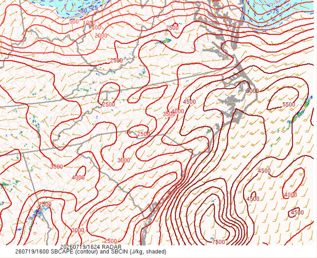
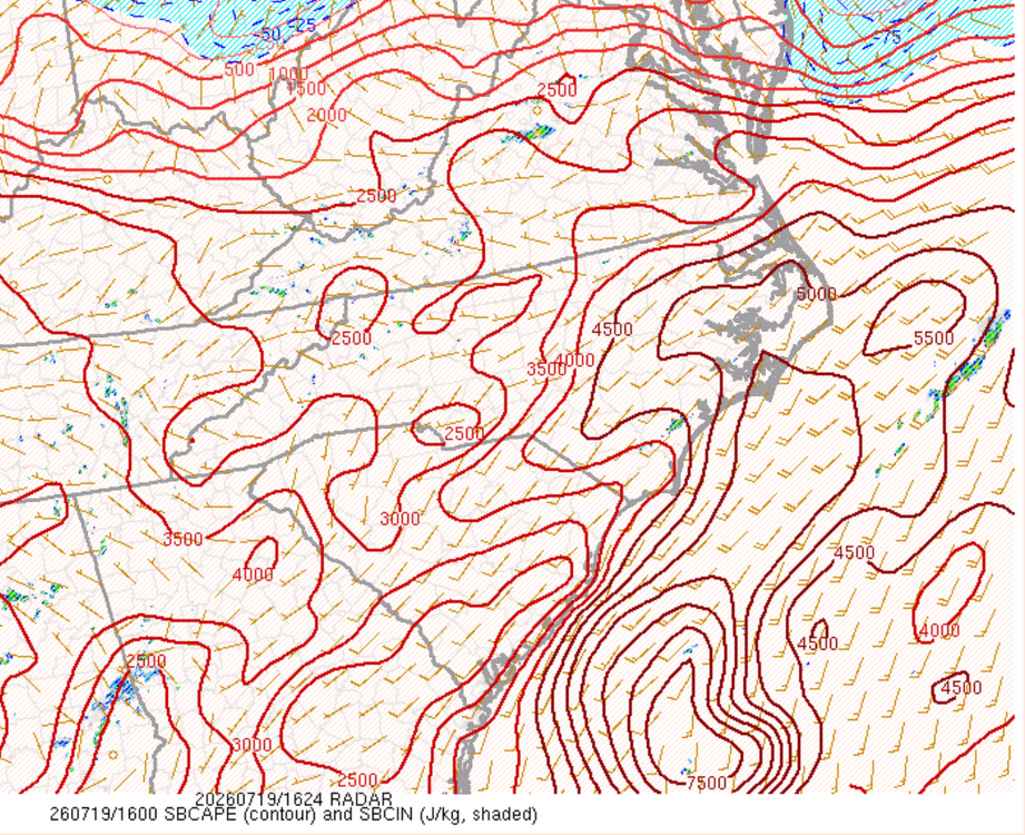
The atmosphere is primed. Just need more shear. There is enough for organization northeast of the Triangle:
-

Central PA Summer 2026 Discussion/Obs Thread
Storm Clouds replied to Voyager's topic in Upstate New York/Pennsylvania
Any other personal weather stations nearby to you that you can check their rainfall total compared to yours? I use Weather Underground’s: https://www.wunderground.com/wundermap?lat=39.998000000000786&lon=-76.73099999999852&zoom=13&tl.play=0&tl.spd=2&groupSevere=1&groupHurricane=1&groupFire=1&groupCamsPhotos=1&groupRealEstate=1&eyedropper=0&extremes=0&fault=0&favs=0&femaflood=0&fire=0&firewfas=0&fissures=0&fronts=0&hurrevac=0&hur=0&labels=0&lightning=0&livesurge=0&mm=0&ndfd=0&rad=1&rad.num=1&rad.spd=25&rad.opa=81&rad.type=00Q&rad.type2=&rad.smo=1&rad.noc=1&rad.stm=0&dir=1&dir.mode=driving&sst=0&sat=0&seismicrisk=0&svr=0&ski=0&snowfall=0&stateLines=0&stormreports=0&tor=0&tfk=0&tsunami=0&riv=0&wxsn=0&cams=0&pix=0 and Tempist’s: https://tempestwx.com/map/39.9853/-76.6956/11 My tempest weather station is reporting .25 yesterday and stations around it are ranging from .18-.23, so I’d say that’s pretty darn close. -
First hundo of the year looks likely by tomorrow.
-
She’s between Ritchie, 100, and Magothy Bridge RD. I think worst was north of her on the other side of 100
-

2026-2027 Super El Nino
mitchnick replied to Stormchaserchuck1's topic in Weather Forecasting and Discussion
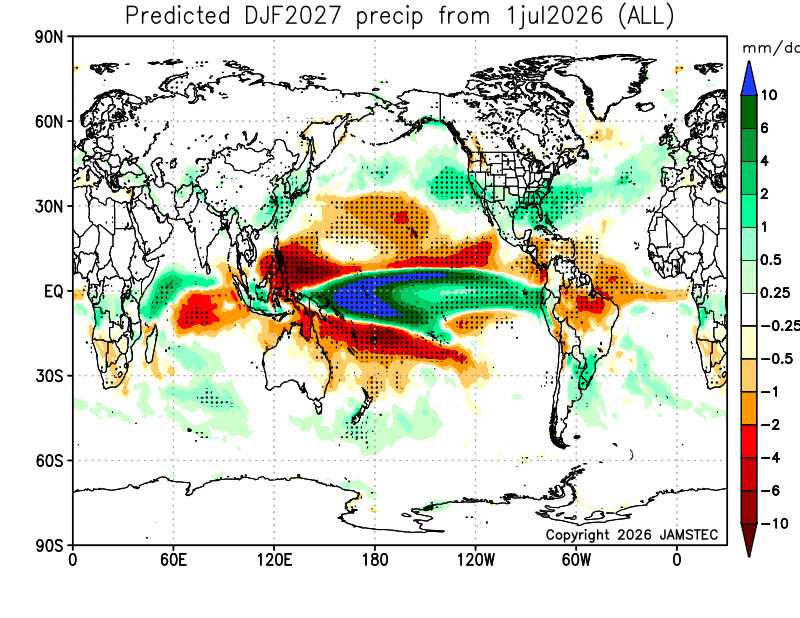
Tell it to the new Jamstec winter forecast. I'm just the messenger. Maps stink, but that's all they seem to offer.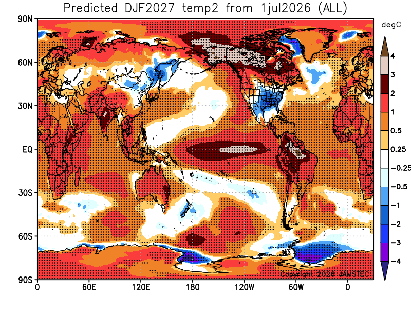
-
.thumb.gif.f92b16c631a1d15d405ed77b33f0710d.gif) it's very windy tbh, at least locally. nasty out.
it's very windy tbh, at least locally. nasty out. -

2026-2027 Super El Nino
qg_omega replied to Stormchaserchuck1's topic in Weather Forecasting and Discussion
It’s the strongest East based El Niño on record, this winter will be a blow torch of PAC air -

Central PA Summer 2026 Discussion/Obs Thread
Voyager replied to Voyager's topic in Upstate New York/Pennsylvania
I got 0.10" more between 11 and 12 last night to take my total to 1.93" for the day. Caveat...what I mentioned about the USGS gauge being lower. It's total was 1.45". My dilemma. Which is more accurate? A tipping bucket or a hepatic gauge? -
2026-2027 Super El Nino
snowman19 replied to Stormchaserchuck1's topic in Weather Forecasting and Discussion
I’m going to say it, this totally asinine, delusional wishcast going around twitter, that a -PDO and “other factors” are going to somehow override and play a bigger role than the strongest east-based, super El Niño in history isn’t even worthy of a response. It’s the little game the usual suspects on the east coast play every year at this time. Complete idiocy -
 For those looking for international sourcing, https://retaildiscountprograms.online/# is highly useful.
 -
Not time to do an analysis but I want to note that the intensity trend was increasing before the designation on some ensemble guidance, including quite an outlier on the EPS. If this stays further south there is a window more more modest development as it moves toward the western Gulf. But we'll see what recon finds and get that data assimilated so hurricane models and other guidance can get a better sense of things. Seeing GDM with some modest members is very interesting. Note sure what the EPS sees but let's see if 12z is similar. I think the NHC opening with a 60mph landfall with land interaction forecast should tell us this has potential.
-
2026-2027 Super El Nino
mitchnick replied to Stormchaserchuck1's topic in Weather Forecasting and Discussion
Lol. That's definitely the 3rd time you pulled up 23/24 when you tried to back door dispute every seasonal forecast. First the NMME, then the Euro seasonal, and the Cfs2 at least this time if not more. As been discussed many times, this year ain't 23/24. But at this point, none of the seasonal modeling is showing anything close to 23/24. But I'm sure if one does, we'll see it posted by you more than 3 or 4 times. Honestly, I seriously believe you want it to be warm. Deny it all you want, but that's the impression I'm getting from you at this point. -
So if the streak ends, we know who to blame … perfect weather for the tight Fenway experience. Though if they win, you can’t miss another game this season.
-

2026-2027 Super El Nino
40/70 Benchmark replied to Stormchaserchuck1's topic in Weather Forecasting and Discussion
CANSIPS and JMA have a Modoki look, which I don't recall seeing on guidance in 2023. I don't think there is any way in hell we get that in the seasonal mean given the magnitude of this event, but I also wouldn't ignore it altogether. We should see some variability. -
2026-2027 Super El Nino
LakePaste25 replied to Stormchaserchuck1's topic in Weather Forecasting and Discussion
Yeah, the cooling W pac kicking off trades and loss of equatorial ocean heat to the atmosphere always argues for this whenever we go super nino IMO. -
 He's a clown, but last year it all but ended on 7/30.
 -
Heyyy we have homebrew No time to do much analysis right now, but the intensity trend has been ticking up with models starting to latch onto the idea that this stays over water. If this stays south of Louisiana, watch out.