All Activity
- Past hour
-

December 2025 regional war/obs/disco thread
Great Snow 1717 replied to Torch Tiger's topic in New England
Yea just ignore the upcoming pattern... -
There a couple of opportunities to watch including perhaps even on Christmas Day.
-
I think I clarified it a few times. I said maybe we can take our chances with a front ender, but it’s not wrong to say the pattern stinks.
-
We’ll see. I think Steve used the word volatile and I agree. It may feel a little like a rollercoaster temp wise with anomalies leaning cooler the further north you go with more wedging during times of WAA.
-

Central PA Winter 25/26 Discussion and Obs
pasnownut replied to MAG5035's topic in Upstate New York/Pennsylvania
it was 14 here. Cold enough for me. Yes...I said what I said. My bones don't need single digis anymore. Just cold enough to snow and hold it, but yeah i guess frozen ground helps during warm ups like the see saw thats on the way. -
Did the Norrisville slantsticker get blowback? lol...it's 6.2" in the PNS from yesterday evening
-
11/30: Mix of sleet and light rain for a couple hours before switching to light cold rain. 12/2: Mix early in the morning before flipping to hard, cold rain. 12/5: 2.25”. 2” in the man event and 0.25” later that evening/overnight. 12/13: 1.25” Running Total: 3.5”
-
It would have been insane to end this run of cold with almost no snow....
-
Central PA Winter 25/26 Discussion and Obs
pasnownut replied to MAG5035's topic in Upstate New York/Pennsylvania
Such an HR response.... Well said bud. I know i make you wince every so often.....gotta keep ya on your toes. A little uplsope wind in them shorts had to feel good yesterday. Its friggin cold -
Sound effect snows on OBX
-
Low of 18 here. Dew point low of 3. Currently at 9:22 it is 22/8 with a wind chill in the low teens easily. Wind was really whipping last night.
-
12/14: 2.1” Season Total: 3.2”
-
Appreciating the deep January vibes today. 15F at 8am and a pack in no rush to obliterate itself. At least the cold start to Dec had a worthy finale.
-
That “lake effect” band over far east NC put down some serious snow near Fairfield. Pics are incredible looks like a couple inches… Don’t see that often!
-
Also the earliest in the year it has gotten this cold at GSO since Nov 25th 1970
-
That lakes energy around the 20/21 seems like it could be the key to a quick little thump in the ensuing days. Wanna see that move souther/stronger and keep us colder. Then just make the 06z GFS progression a bit better and we can get a thump…
-
Lowlands outside of Annopoils Total so far 4.5" Come on 30-40" season lol
-

Central PA Winter 25/26 Discussion and Obs
Mount Joy Snowman replied to MAG5035's topic in Upstate New York/Pennsylvania
Low of 14. Winter, it is here. -
I just feel like those kind of events never ever ever work out for us. GEFS/GFS always shows it but never happens. EPS/AIFS pretty much say shut the blinds for this week, which probably won't surprise anyone. Next very tiny window might be early next week before we hope something opens up around or after the holidays.
-
Central PA Winter 25/26 Discussion and Obs
pasnownut replied to MAG5035's topic in Upstate New York/Pennsylvania
lol. You have access to my numbers do ya :). I'd rather not "Ruin" my portfolio. thats a good one right there. -
glad we don't live at H5 for a while
-

December 14th - Snow showers or Plowable snow?
weatherwiz replied to Sey-Mour Snow's topic in New England
The other great part of blogging and posting your reasoning for forecasts is you have something to look back on. This is why I wish I was more active with blogging but really dropped off over the last several years. So I try to rely somewhat on memory which isn't always the best metric. But when I'm forecasting I will try to think of not necessarily similar events but I try and visualize what the response will be to certain things. One thing I learned from Ekster way back to the eastern days was (and this is about thunderstorms) to try and visualize how a thunderstorm will respond to the environment it is in. But I try and extrapolate this concept across weather phenomena. With winter storms, I always try and paint a picture in my head of how the radar presentation will look at how it will evolve based on how the atmosphere is evolving. This concept has really helped me produce some solid snowfall forecasts over the years, but (in the cast of this past storm), if I am underplaying/overplaying certain aspects I will be way off. -
Tied with 2024. The last time it dropped colder than 11 was Dec 2022 when it dropped to 5.
-
Laughs in Clarksville
-

E PA/NJ/DE Winter 2025-26 Obs/Discussion
Violentweatherfan replied to LVblizzard's topic in Philadelphia Region
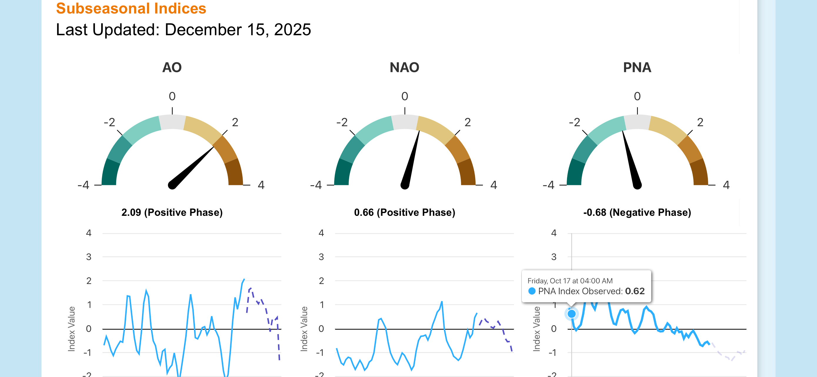
Not buying into that time frame until the PNA is positive and there is some blocking