All Activity
- Past hour
-

2026 Mid-Atlantic Severe Storm General Discussion
Stormchaserchuck1 replied to Kmlwx's topic in Mid Atlantic
Days with cool temps usually don't do much severe wx wise in the area. This is 3x this season where they had risk with 50s and 60s and it amounted to nothing. -
I’ll be 109 and I expect an invite. Until that time, as always ……
-

2026 Mid-Atlantic Severe Storm General Discussion
SnowenOutThere replied to Kmlwx's topic in Mid Atlantic
My point is this storm deserved a Tornado warning at some point in its lifespan. -
Was it July 2018 where we got 18"? One of those July's, I remember it raining like crazy Over the years our thunderstorm season has shifted from the Spring to late June and July.
-
Pretty neutral here
-

Texas 2026 Discussion/Observations
Stx_Thunder replied to Stx_Thunder's topic in Central/Western States
3 in. + hailstones appear to be ongoing in the elevated supercell with a very notable and large hail core on radar (sfc temp around 60 F), in Athens vicinity in NTX. -
2026-2027 El Nino
Stormchaserchuck1 replied to Stormchaserchuck1's topic in Weather Forecasting and Discussion
What would you say is the chance of a continued El Nino in 27-28? 5%? 10%? I would say 5-10% -
I’ll turn 110 that year in December. Big party planning in the works!
-

Central PA Spring 2026 Discussion/Obs Thread
Voyager replied to Voyager's topic in Upstate New York/Pennsylvania
52 degrees...ugh. Too damn cold. -
West to East as the LP moves from Parkersburg to Pittsburgh.
-
Texas 2026 Discussion/Observations
Stx_Thunder replied to Stx_Thunder's topic in Central/Western States
SPC has (Finally) got there act together. Indicating the level 2/2 severe hail intensity area in the latest D1 outlook this afternoon, very close to SAT. Which I mostly agree on for the very large (potentially 5+ in. hail) target zone. Convective initiation is beginning in the Edwards Plateau. San Antonio area no doubt, definitely needs to be on alert through this evening. Abnormally steep ML lapse rates around & above 8, evidently remain across the state today with large hail producing elevated storms ongoing behind the sfc polar front in N-NETX. Even where sfc temps are actually in the 50s. -

2026-2027 El Nino
michsnowfreak replied to Stormchaserchuck1's topic in Weather Forecasting and Discussion
Id think its way too early to say anything. I mean "potential" is there for a lot of stuff. But with the ability to make snow im sure ski areas will be fine regardless. -
The rain bands had been moving SW to NE, but it looks like they've shifted to W to E. Some yellows on the path to hit Fairfax.
-
Loser shit, hate it
-
Yesterday was cool here but sunny. Today is dog shit here.
-
2026-2027 El Nino
Stormchaserchuck1 replied to Stormchaserchuck1's topic in Weather Forecasting and Discussion
It's probably an error. I haven't played around with it yet, but I will probably start keeping a record to see if there is an advantage vs the market. May is 62F - I'm going to say below. -
I'll take a 12z Euro, 12z ICON, 19z HRRR blend. All a half inch+ here. Probably another fail though lol.
-
2026-2027 El Nino
Stormchaserchuck1 replied to Stormchaserchuck1's topic in Weather Forecasting and Discussion
The actual PDO-Strong El Nino connection is not as strong as you would think. Here is the strongest events, it's pretty close to neutral - bigger cold pool being hugging, right outside the ENSO warm SSTs, I'd say more in the North Pacific High area (-NOI). -
Today's euro is showing multiple shots of well below normal air coming in the next 10 days.
- Today
-

2026 Mid-Atlantic Severe Storm General Discussion
NorthArlington101 replied to Kmlwx's topic in Mid Atlantic
I’m not convinced that’s a TDS in this radar snapshot at least tho I’m hardly a pro here. EDIT: looking at the radar loop I think it *was* one at a point before this screenshot but idk if I t think it’s on the ground here. Might be some debris fallout -
It's May in the CC era, it doesn't take much to get above normal. The pattern is more about keeping the 90+ heat away than enforcing a cool pattern
-
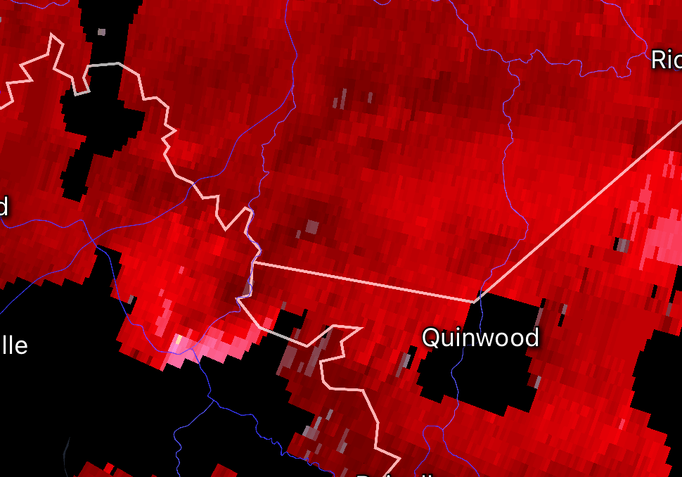
2026 Mid-Atlantic Severe Storm General Discussion
SnowenOutThere replied to Kmlwx's topic in Mid Atlantic
I don't like to criticize the NWS but Charleston dropped the T-storm warning and now has this completely unwarned as it approaches a town which just seems really bad and one of the worst misses I've seen when it comes to tornado signatures. It had a better circulation and more lofted debris ball beforehand too! It even had a separate debris ball 30 minutes ago now!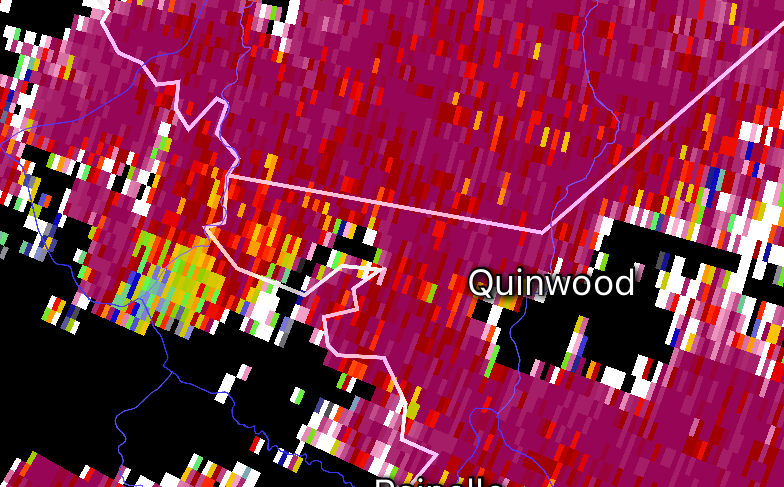
-
As I recall, we did the same in the first half of May 2017. I remember a day or two that struggled to get out of the 40s, which is what this looks like. Not 2020 levels by any stretch, but still pretty cold. Regardless of intensity, it does seem to have a little staying power, especially on the Euro ensemble. The trough reloads and swings back through later next week and it stays troughy in the east through the end of the run.
-
Heading into our 29th summer here, all the hail that has landed in our yard (only 2,000 sq.ft., but still) wouldn't fill a one-gallon bucket. One storm might've dropped a flattened chunk 5/8" on its longest surface. (On August 30, 2007, nickels/quarters hail 6-8 miles southeast from from our place accumulated up to 4" and fully defoliated/partially debarked trees on about 2,000 acres, so that kind of excitement isn't impossible here.) Low 60s for the high here, about 10° above the forecast. 3 hours of midday PC did its work.
-
Doesn't look like it will get to 68 today as forecast. IAD topping out at 59 so far.


