All Activity
- Past hour
-
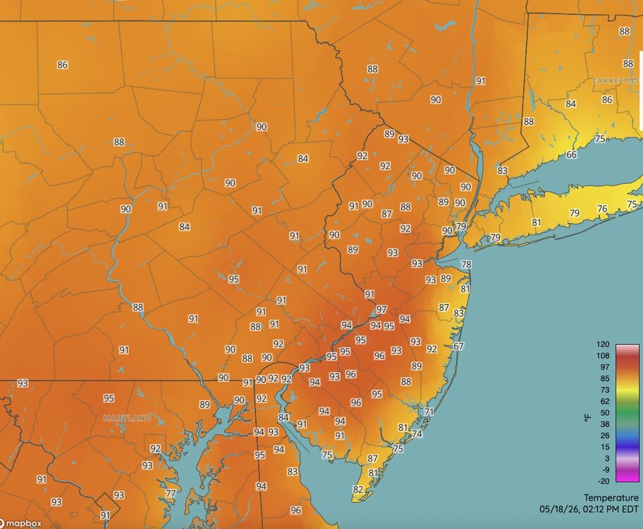
Currently a 97 near TTN. Cooking over the interior of NJ today.
-
92/66 here.
-
93 currently. Pool is waiting for 5:01 haha
-
Yep 89 around here as well. Valley FTW. Dews are coming up as well. We take.
-

2026-2027 Strong/Super El Nino
michsnowfreak replied to Stormchaserchuck1's topic in Weather Forecasting and Discussion
I would never count on a "good" winter in a strong nino. But I also wouldn't just assume that the stronger the nino the worse the winter will be. There are other pieces of the puzzle besides enso. -
Cooler down this way, 82. Lawn starting to show a bit of burn.
-
2026-2027 Strong/Super El Nino
michsnowfreak replied to Stormchaserchuck1's topic in Weather Forecasting and Discussion
They dig and dig to find this stuff lol. -
89F so far at BDL. They should be able to tickle 90.
-
87.1/64 So wet , so moist, so free
-

2026 Mid-Atlantic Severe Storm General Discussion
Stormchaserchuck1 replied to Kmlwx's topic in Mid Atlantic
I just saw my first cloud!- 339 replies
-
- 1
-

-
- severe
- thunderstorms
- (and 7 more)
-

2026 Mid-Atlantic Severe Storm General Discussion
SnowenOutThere replied to Kmlwx's topic in Mid Atlantic
Thoughts on today? I listed out some of my thoughts in the Discobs thread but do we have any hope of a boundary causing forcing? -
Hmm I'm not sure it's a wet pattern right now
-
91F.. I'm usually 5-7 degrees cooler than DCA, not today.
-
Got nailed by a bowing segment at the workplace. Probably around 60 mph gusts. Power went out, generator has kicked in.
-
We’re already over 2000 CAPE, -6 lifting index, 7.5 ML lapse rates, and lost 150 CIN in the past three hours. It sucks we have no shear or forcing because our thermodynamic parameters are really good! We even got 1200 DCAPE for severe winds. Maybe a bay breeze boundary can get parcels to the LFC?
-
Thankfully peak heating doesn't kick in until well after the solstice
-
Seabreeze enhancement?
-

2026 Mid-Atlantic Severe Storm General Discussion
high risk replied to Kmlwx's topic in Mid Atlantic
I'm on board for thunderstorms later Wednesday, but the upper level flow looks *really* weak which should reduce the severe potential. There may still be enough shear lower in the profile to get some wind threat, but the ceiling for this event looks to be low. -
Just 0.17" here early this morning. 0.59" 3 day total.
-
I’ll settle for below average rain at this point by our normal standards. I’d be over the moon if we could just average a .25” per week at this juncture. .
-
I like how at the end of its run we get days of summer storms. Hot and humid of course, but with daily storms is nice.
-
92/66
-

Central PA Spring 2026 Discussion/Obs Thread
Mount Joy Snowman replied to Voyager's topic in Upstate New York/Pennsylvania
MDT doing MDT things haha.......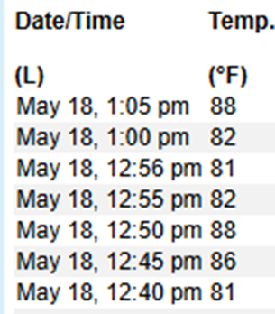
-
Seeing most reports between 55 mph and 65 mph as that line moves through NE IL/NW IN.


