All Activity
- Past hour
-
 Max: 24 Min: 2 Snow: 0.5
 -
 ULL up over Maine just cut that s/w down to almost nothing at the Surface. Goofy Fucking System model.
 -
Have fun and be ready for some wind, which I am sure your aware. I was somewhat stunned to see gusts forecast up to 55 mph in Asheville for Saturday. Just looked at Banner Elk: Saturday Partly sunny, then gradually becoming sunny, with a high near 17. Wind chill values as low as -10. Windy, with a northwest wind 24 to 34 mph, with gusts as high as 60 mph.
-
Could be north of that
-
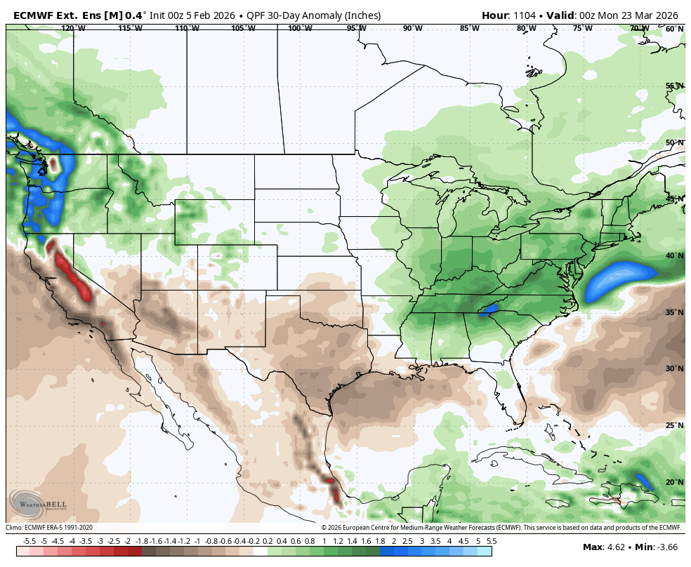
Weeklies for last week of February into March look stormy and cold


-
wienermobile coming to delaware this weekend

-
 I don't know. Looks like the SW is coming out instead of getting stuck but that doesn't mean it will be a good result lol. Also do I email my W2s to you?
 -
 You mean it changed, 152K
 -
 GfsAI has a storm for next Sunday. Looks snow to rain, then back to snow as low travels through N VA.
 -
 They won’t radiate Saturday night with strong CAA but Sunday night they might. Winds take a while to subside and there could be some cloud cover trying to move in so we may not see a lot of radiators going wild during this cold shot, but the best chance is Sunday night.
 -

E PA/NJ/DE Winter 2025-26 Obs/Discussion
Birds~69 replied to LVblizzard's topic in Philadelphia Region
Which literally means nothing that far out. Track the stuff on your doorstep first... 28F -
The East had a winter. The West had a summer.
-

Central PA Winter 25/26 Discussion and Obs
MAG5035 replied to MAG5035's topic in Upstate New York/Pennsylvania
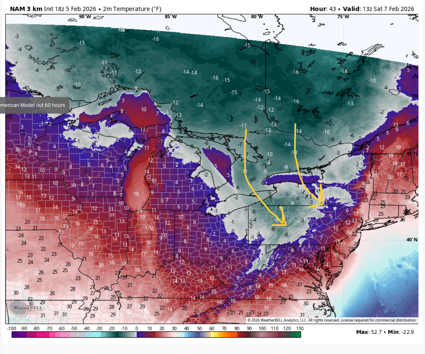
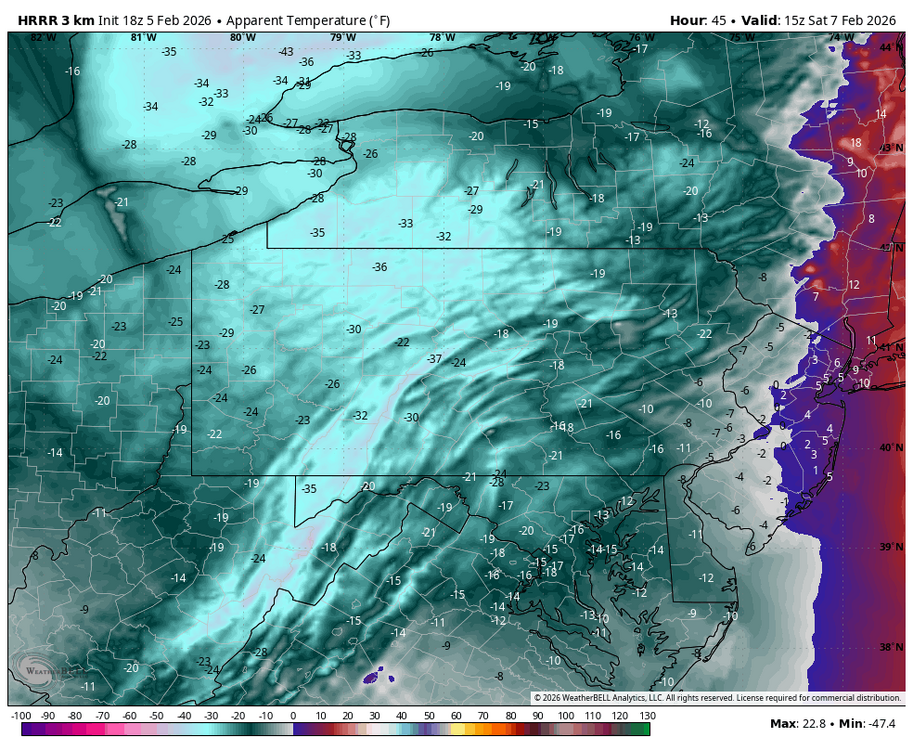
Geesh, I guess not. I’m probably in the minority here but I’m not really all that impressed with the wind threat if we’re talking strictly from a mph standpoint. Most guidance and that includes the high res stuff like the HRRR that normally ramps up surface winds barely support advisory winds much less anything of the variety that would cause widespread power outages. But I could get on board with a wind advisory for 45-50mph I suppose. Basically a typical wind event in other words, it gusts to 60mph at @canderson’s house in those anyways haha. This event also has a more northerly trajectory to the wind as well being more NW or even NNW.. less of a direct downslope component to enhance wind gusts IMO. What I am impressed with is the COMBO of the winds and cold temperatures. Dynamically this will be the coldest shot of the winter to date. The more northerly component to the wind minimizes modification of the airmass source travelling over the Lakes, which already have a good bit of ice with Erie >95% covered. Non-diurnal “High” temps for Saturday will occur before about 3-4am Sat morning. Sat daytime temps will struggle to get out of the single digits in most of the area. Laurels and some north-central might not crack zero. You can see how there’s an appendage of non-modified Arctic air that reaches PA. I drew the rough surface wind direction. It mostly goes over the frozen portion of Huron and Erie. Saturday morning will probably be the worst for wind chills, though it won’t be good all day. I think most of that extreme cold watch has a good chance of being upgraded to the full blown warning. Here’s the kind of wind chills the 18z HRRR put out after daybreak Saturday morning. I haven’t really seen those kind of wind chills since the Christmas 2022 cold shot.
-
stormtracker changed their profile photo
-
You guys will be shocked to know that the 18z GFS h5 map is vastly different out west. But looks like that s/w is headed for shredderola
-
 Do the valleys still radiate in these events, or do winds protect from that?
 -

Friday February 6 FROPA / WINDEX small event
Damage In Tolland replied to HoarfrostHubb's topic in New England
Mesos , and then Euro in that order -
We still have another couple weeks of Niña trade winds to fook any chances of getting Niño benefits. That's just the way it works around here unfortunately.
-
 SSW November's? I don't know. Maybe 10? On my old computer I plotted all 10mb events since 1948, but I don't have that data anymore, just memory of what the end result showed. 10mb warmings are lagged to AO, and 10mb coolings happen with AO in now-time (0-day)
 -
 I'll take my chances with that after this past 7 year clownshow.
 -

Winter cancelled/uncancelled banter 25/26
Stormlover74 replied to Rjay's topic in New York City Metro
No liberty is someone else -

E PA/NJ/DE Winter 2025-26 Obs/Discussion
Duca892 replied to LVblizzard's topic in Philadelphia Region
Andddd the midweek storm on the GFS is like nothing like it was at 12z lol -
E PA/NJ/DE Winter 2025-26 Obs/Discussion
Birds~69 replied to LVblizzard's topic in Philadelphia Region
NJ may receive a nice little event... 29F -
 Interesting. How many occurrences were there?
 -
@GaWx Did a research earlier this season and found that a Nov SSW had a significantly high correlation with cold December and January. I found in my research that a Nov SSW had ~+35-40 day lag with the -AO/NAO, and that worked out this year, but the correlation numbers weren't so high on the Pacific pattern. Gawx also found that -ENSO/-PNA Decembers led +PNA January's 10/10 times! donsoutherland did an independent research and found the same thing. It worked out this year time 11/11. Why? I don't really know. The opposite side +ENSO/+PNA Decembers leading -PNA January's doesn't work out the same.
-
(002).thumb.png.6e3d9d46bca5fe41aab7a74871dd8af8.png)
E PA/NJ/DE Winter 2025-26 Obs/Discussion
ChescoWx replied to LVblizzard's topic in Philadelphia Region
Indeed the NAM a little more impressed with the snow squalls tomorrow night. Saturday will be the coldest day of what has been one of our coldest winters in years!