All Activity
- Past hour
-

“Cory’s in LA! Let’s MECS!” Jan. 24-26 Disco
Henry's Weather replied to TheSnowman's topic in New England
Forgot about December 2020! Feb 2021 i left out because coastal plain was screwed. Jan 2022 I also forgot. Of these December 2020 should be the best analog -
Euro looks like crap right off the bat. Sent from my SM-G998U using Tapatalk
.thumb.jpg.9126427d6c34980ebb3fef4e619fd647.jpg)
-

“Cory’s in LA! Let’s MECS!” Jan. 24-26 Disco
Snowcrazed71 replied to TheSnowman's topic in New England
I'm curious whether they are going to host Winter Storm Watches later today even though it's early -

Winter 2025-26 Short Range Discussion
Stevo6899 replied to SchaumburgStormer's topic in Lakes/Ohio Valley
Looks like macomb twp coming in at 4 inches. Snow depth has to be close to double digits there. -
If Dr. No is still like this after the next few runs...
-
I can’t see it yet so thanks for the explanation. I mean obviously we take.
-
That's pretty much it
-
You don't need any of that info in the real world so don't sweat it.
-
amped
-
... gotta sniff the mix
-
8° here this am...lowest so far, lots more to come!
-

“Cory’s in LA! Let’s MECS!” Jan. 24-26 Disco
The 4 Seasons replied to TheSnowman's topic in New England
Where are you? Dec 2020, Feb 2021 and Jan 2022 was major, depending on where you are of course. -
I don't like it as much but it IS climo I guess.
-
06z was a better solution. 12z got over its skis a bit and the overrunning is kind of disjointed with that trailing energy more than 06z was. They are kind of separate on both solutions but 12z is moreso.
-
IT’S OVER!!!!
-

January 25/26 Jimbo Back Surgery Storm
stormwatcherJ replied to Jimbo!'s topic in Southeastern States
LOL... not willing to say how much of what, but willing to say "13%." -

Pittsburgh/Western PA WINTER ‘25/‘26
Rd9108 replied to Burghblizz's topic in Upstate New York/Pennsylvania
I think we have to be careful with rooting for the more amped looks. Cant let that warm nose sniff the area. -
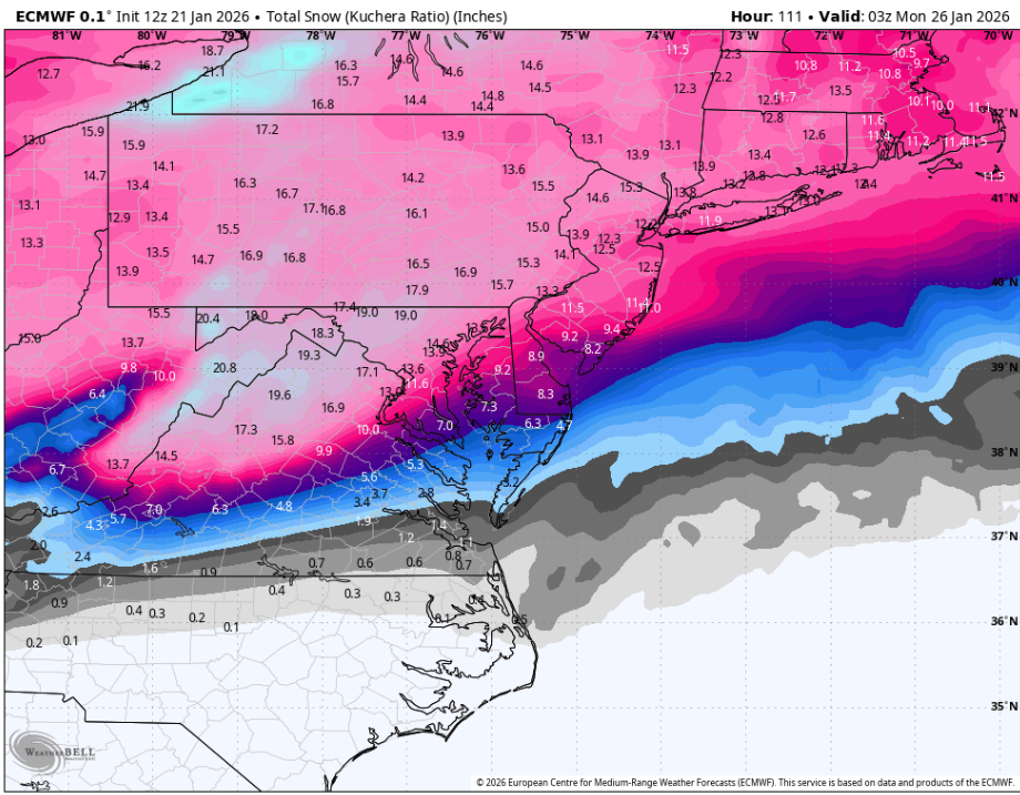
 I'm not gonna say it's impossible because in this set up, they could get near 18 inches. What is impossible is them ever accurately measuring 18 inches. Especially in a long duration storm, they usually f up as only they can.
 -
1.5 QPF at those temps is probably realistically pushing 20 inches out here. I still think we will mix out here as well though. Insane run.
-
Thank you. Seems like 6" - 10" from the bay to I-95, 8" - 12" west of there.
-

“Cory’s in LA! Let’s MECS!” Jan. 24-26 Disco
40/70 Benchmark replied to TheSnowman's topic in New England
Keep me posted. -
 I've tracked storms long enough to 4 days is still an eternity for things to change. I will say given the wide swath of precip and depth of the cold there's enough wiggle room in all directions where I can't see that much going wrong with this.
 -
It's like 6-8 hours after the precip rolls in that it switches over east of 95. Hours and hours and hours of ZR or sleet after
-
Mixing still seems to be kept at a minimum for the metros.
-
Does this storm look like PDII type snowfall, sleet,ZR distribution areawide?

.jpg.5bd355a69d941b53646ce6742d587e9f.jpg)


