All Activity
- Past hour
-
Slightly south with a stronger HP
-

January 2026 regional war/obs/disco thread
Torch Tiger replied to Baroclinic Zone's topic in New England
Nice to see the sun angle starting to make impacts! Lfg -
The CAM models will be interesting once the system gets going over Texas. I don't think I've had a chance to actually look at them with a storm in progress.
-

MO/KS/AR/OK 2025-2026 Winter Discussion
The Ole Bucket replied to stormdragonwx's topic in Central/Western States
12Z GFS running and seems really similar to last run -
Super interested in if the GFS changes anything
-
I mean that matters at this juncture. and beats 25 miles north
-

January 25/26 Jimbo Back Surgery Storm
Thrasher Fan replied to Jimbo!'s topic in Southeastern States
12z GFS similar to previous run out to 36h -
If you moved to Frederick for snow purposes...umm...we need to have a talk
-

Pittsburgh/Western PA WINTER ‘25/‘26
colonel717 replied to Burghblizz's topic in Upstate New York/Pennsylvania
I would guess more than 15 inches or more may do it. 20 definitely would if we are going back to 1800's -
Is the GFS still relied upon once these shorter range models come into play?
-
Oh that RGEM was a significant improvement and was 90% snow for us on that run...we ride the mix line for 12 hours BUT its rate dependent, during dry slots its sleet and the snow line sinks south during heavier periods...and even during lighter periods the mix line never gets more than a few miles NW of us...1 degree colder and it's 100%...a huge improvement from 12 hours ago! BUT...that stuff you see to our SW won't make it here...we are about to dry slot at the end of the run and its over. The stuff in WV and OH won't make it across the mountains because with the primary going to our NW the flow ill be out of the NW and downsloping and the mid level dynamics are going to our NW so there won't be anything to cause additional precip.
-
Thru 36 same thing pretty much the same except heights are like 25 miles south in the east lol
-

January 2026 regional war/obs/disco thread
tamarack replied to Baroclinic Zone's topic in New England
Can't recall seeing that as a forecast, but we've had at least 3 stretches of 40-day BN temps in Maine. Gardiner (9 miles south from AUG): Nov 22-Dec 30, 1989: 13.2 BN Dec 26, 1993-Feb 3, 1994: 11.5 BN New Sharon (western Maine foothills): Jan 26-Mar 6, 2015: 12.7 BN ariof noted 2 of those 3. A shorter (25 day) run was Dec 14, 2017 thru Jan 8, 2018: 15.9 BN -
 I think the northern areas of the forum should see a foot easy, even up to 15-18 in select spots.
 -

January 24-26: Miracle or Mirage JV/Banter Thread!
Scuddz replied to SnowenOutThere's topic in Mid Atlantic
You rang? -

Possible Record Breaking Cold + Snow Sunday 1/25 - Tuesday 1/27
SACRUS replied to TriPol's topic in New York City Metro
-

1/24-1/25 Major Winter Storm - S. IL, IN, MI and OH
SouthOaklandCtyWX replied to A-L-E-K's topic in Lakes/Ohio Valley
If you extrapolate the NAM it’d probably be about an 8-10” snowfall for the Detroit city proper. I’d definitely rather be downriver for this one instead of north. -

Possible Record Breaking Cold + Snow Sunday 1/25 - Tuesday 1/27
eduggs replied to TriPol's topic in New York City Metro
What's wrong with describing what the model shows? -

Possible Record Breaking Cold + Snow Sunday 1/25 - Tuesday 1/27
BoulderWX replied to TriPol's topic in New York City Metro
well that was precisely why I cautioned against doing so 5 days out lol - we didnt even have a grasp on synoptic set up. all good - still going to be a nice 6-10 event -
Possible Record Breaking Cold + Snow Sunday 1/25 - Tuesday 1/27
eduggs replied to TriPol's topic in New York City Metro
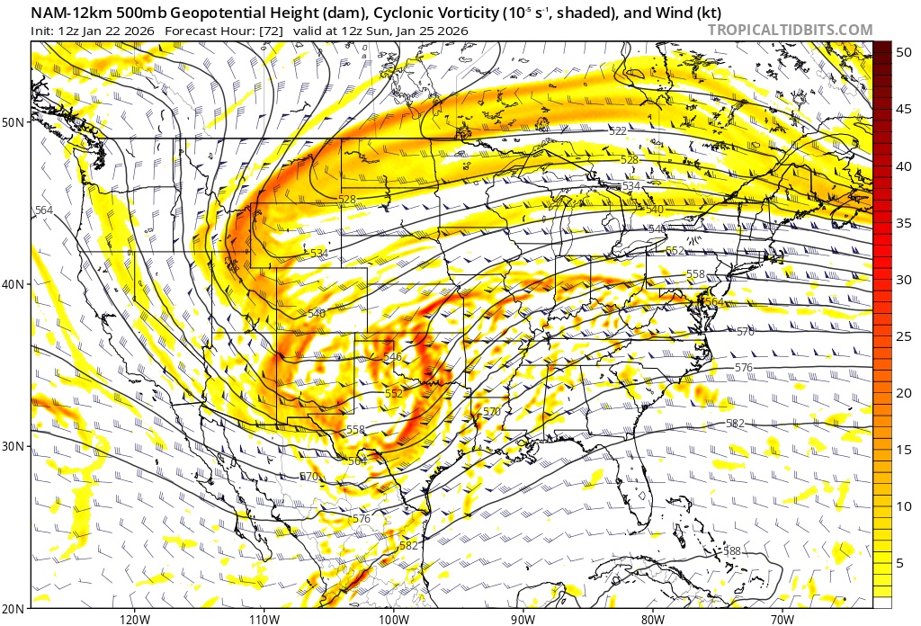
Disagree about the NAM. Look at this shortwave over OK at 72hr. Takes it straight to Chicago. That's sharper than 6z. Will take a primary and pronounced mid-level lows to WPA and then NYS. No way to block that mid-level warming Sunday afternoon with that upper level setup. Other guidance is less sharp... but NAM is good at this. Let's hope it's still beyond its accurate range.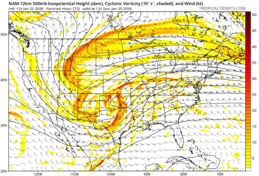
-
We're all going to see sleet, some more than others. But it's coming for us all..N and W not protected. I hate it, but we might as well try to get a solution with the least amount of it. At least youll hang on to snow for a few hours more than most of us
-

Possible Record Breaking Cold + Snow Sunday 1/25 - Tuesday 1/27
Northof78 replied to TriPol's topic in New York City Metro
NAM would be a major snowstorm (or basically two separate storms) with possibly some mix depending with the 2nd system, probably 10"+ regionwide.. -

January 24-26: Miracle or Mirage JV/Banter Thread!
North Balti Zen replied to SnowenOutThere's topic in Mid Atlantic
Lol. (checks for evidence of this thesis) resumes lol. -
No serious changes to gfs thru 24. If anything the confluence is a tiny bit stronger.
-
Might need to wait for this storm to form and move out of the way before getting a clearer picture of what may come behind it. sounds like we still have some tracking ahead of us, which is great news.