All Activity
- Past hour
-
In my book, that’s a solid B…and it would be a B+ if the snow cover was 3”+ on a majority of those 99 days.
-
After 80s on Tues and storm chasing I'm good. Lol. Im so over cold. But would of been cool to get a historical blizzard like this.
-
.thumb.jpg.6a4895b2a43f87359e4e7d04a6fa0d14.jpg)
Central PA Spring 2026 Discussion/Obs Thread
Yardstickgozinya replied to Voyager's topic in Upstate New York/Pennsylvania
Did you hear it too? -
Central PA Spring 2026 Discussion/Obs Thread
Yardstickgozinya replied to Voyager's topic in Upstate New York/Pennsylvania
I don't think they can set off ordinance after the sunsets. -
I’m wondering if we get a different type of crazy cold front this time. Not 50 degrees over 24 hours but 20-25+ in one hour
-
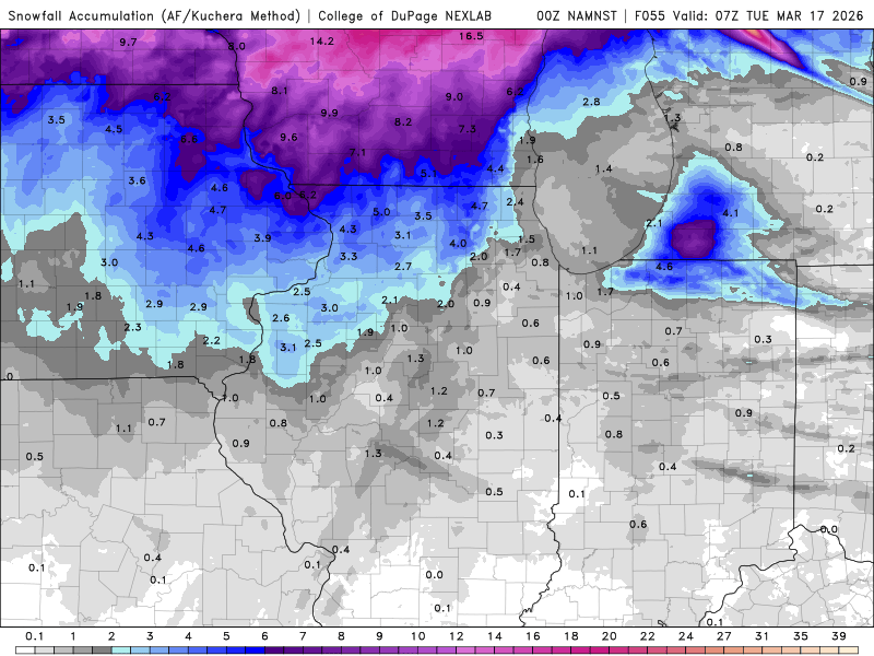
I’m not sure what the NAM is on but…….
- 54 replies
-
- 1
-

-
- severe
- mountain snow
- (and 1 more)
-

Pittsburgh/Western PA WINTER ‘25/‘26
Ecanem replied to Burghblizz's topic in Upstate New York/Pennsylvania
Yesterday it topped at 50mph before the power clipped out and the feed dropped. May have been a higher gust. It’s in a relatively good spot but still can be blocked from NW gusts. -
I'll gladly take 2-4" - I want to see how cold it can get Tuesday morning.
-

Pittsburgh/Western PA WINTER ‘25/‘26
Burghblizz replied to Burghblizz's topic in Upstate New York/Pennsylvania
Very cool! What did it pick up as far as max winds? -
Yep. The poor radar coverage a few years ago caused a tornado to go unwarned in Catawba County and multiple people died.
-

Central PA Spring 2026 Discussion/Obs Thread
Blizzard of 93 replied to Voyager's topic in Upstate New York/Pennsylvania
Is the Gap doing training drills this weekend? -
I would be careful writing those off as mini-supes. With such pristine wind profiles, only about 1k cape can get it done.
-
Yes, exactly the case here. It's not shade...my front yard faces north, and it has less because a lot of the snowfall is blocked by the pine, so it's mostly melted out. MBY faces south, it totally open, and has the 6-8".
-
Wife had maternity shoot in Marshfield today. Man was it brutal out. Wind was howling
-
No, it's not sheltered in the sense that it's shaded....MBY gets decent sun. I think the cold just pooled here well on Thursday AM...if you look at that map, that little appendage to the south, just N of KWLM, is right over me.
-
I'll be prepped and ready to go to my basement on Monday if I need to. This looks like it will be one that will be developing on top of the Metro Charlotte area from the Hickory/Unifour portion southward towards Shelby in Cleveland County. It will accelerate eastward through the midday-afternoon hours. This is could be bad for the Triangle, Greater Richmond, the Metro Washington area AKA the DMV, and Metro Baltimore. Especially, if there are individual supercells form ahead of main squall line or the line potentially forms as line segments with embedded supercells. Situations setting up like this on Monday is why Metro Charlotte needs a NEXRAD Doppler radar site & its own NWS forecast office to provide better radar reflectivity below 5,000 feet in its region. This would also help the Winston-Salem & High Point side of the Piedmont Triad area as well with better lower-level radar reflectivity coverage.
-
Yeah 0z not kind to IL. Lol. Another non event. Ready for spring to stick around
-
It's like that with any large event...
-
Yea, I hadn't sniffed within 10" of average since 2017-2018 until this year.
-
New hi-res NAM really sucking any fun out of Illinois for the event in terms of high amounts. Even furthest western parts of the state.
-
3K NAM shows DCA going from 70 at 6pm to 37 at 7pm. Now that's a cold front.
-
I’m not sure I quite buy it. They’ve held steady all day on the band over the metro. Seems odd that there is such a dramatic shift in one run as things are starting. .
-
Central PA Spring 2026 Discussion/Obs Thread
Yardstickgozinya replied to Voyager's topic in Upstate New York/Pennsylvania
Two extremely bright flashes over the last 15 minutes out this way, both followed by massive explosions. It shook everything. It actually happened during the day they other day here, and they never figured out what it was. Read about something like this happening in another part of Pennsylvania recently. -
Enjoy guys Post pics and videos
-

2026 Mid-Atlantic Severe Storm General Discussion
Eskimo Joe replied to Kmlwx's topic in Mid Atlantic
00z HRRR is legit. Several pre-frontal mini supercells then a solid squall line.


