All Activity
- Past hour
-
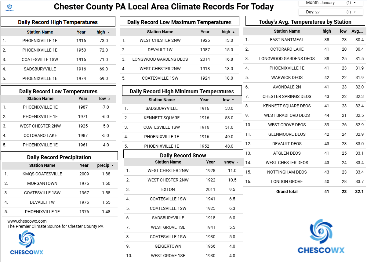
Cape Hatteras- 13.3in. — The two-day cumulative snow record covered the period from December 24th, 1989 to December 25th, 1989.
-
If the public is mad for a storm missing, it’s their own fault. Nowadays they demand more and more lead time for storms, and irresponsible people (laymen and Mets alike) throw out snowfall maps like candy without regards to the likelihood of something happening, forcing respectable ones to address something and potentially make a forecast they’re not ready to make yet
-
I doubt there's ever been a storm where Hatteras gets a foot and we get nothing
-

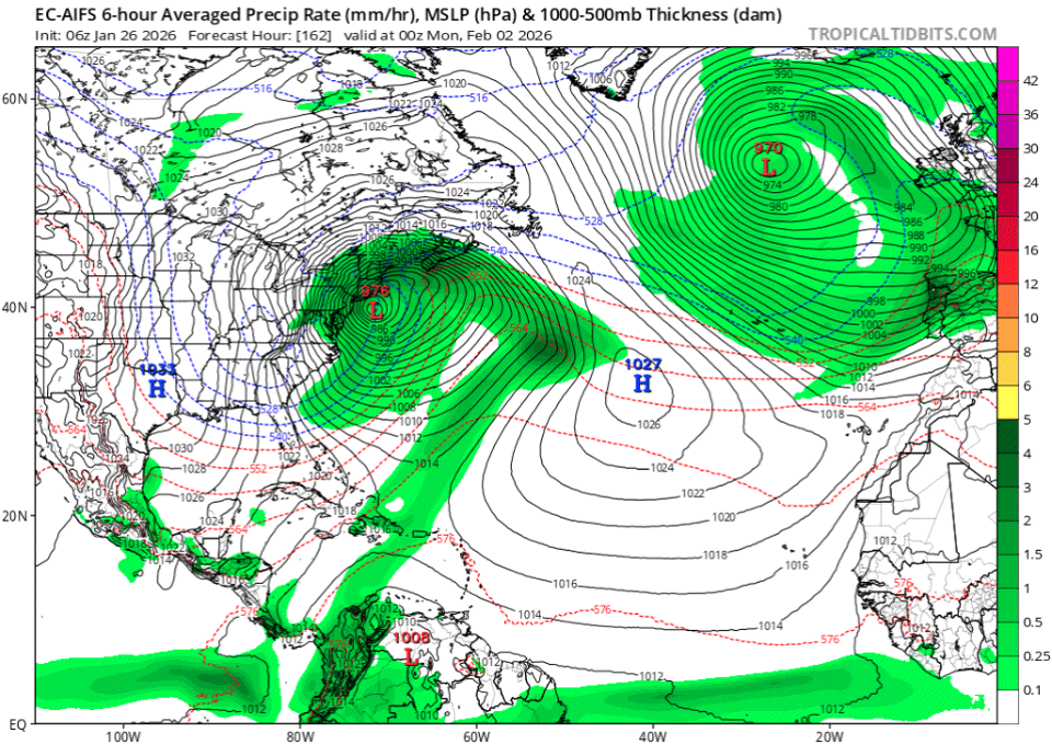
Possible coastal storm centered on Feb 1 2026.
WinterWolf replied to Typhoon Tip's topic in New England
That’s not how this works unfortunately. You see, when the Pope hates a set up, and tells everybody that it will never work etc etc..like he just did with this past one, that’s when we get the storm. When he’s pumped like he is now, it’s pretty much a gonner. We’ve even it many times sadly. So the only plus we have going right now, is that it’s still 5 days away. But the pope being giddy is a bad sign for sure. But maybe he proves his track record wrong(finds the nut) with this one. But it’s not a good sign at all. -
Given how far south this storm will be and the airmass i could see the former
-
Windshields only. But it's common decency to keep stuff like this from happening. Sadly we all know how badly people care about others these days.
-

2025-2026 ENSO
WestMichigan replied to 40/70 Benchmark's topic in Weather Forecasting and Discussion
Getting close to 70" here. Hoping I can crack 100" but that will probably be a tall task. Nice to see you have been cashing in on this pattern also. -

January 2026 Medium/Long Range Discussion
Scarlet Pimpernel replied to snowfan's topic in Mid Atlantic
At this point, I've more or less "given up" on a major, huge storm. It was a long shot anyhow even with the amazing couple of model runs. Though I would be glad if indications went back that way and it were to happen, of course! That said, I'm kind of wondering more now about the possibility of eeking out a minor 2-4"/3-5" type deal, along the edge of whatever monster system develops. It would be cold, high-ratio powder stuff presumably. I think @Bob Chill or perhaps @psuhoffman kind of discussed that the other day to an extent? I don't think this necessarily has to be an all-or-nothing raging blizzard or smoking cirrus that seems to be the general feeling in here from some people. -
I was told at the shop there is no law in VA to clear your car but yeah everyone should do it anyway.
-
Took almost 10 minutes just to drive down my street to Jericho Turnpike this morning. I live on a narrow curvy street and the snow banks plus school buses made it ridiculous.
-

The “I bring the mojo” Jan 30-Feb 1 potential winter storm
olafminesaw replied to lilj4425's topic in Southeastern States
As it stands: Full phase: Canadian, GFS, UKMET(borderline, but just gets it done) Partial/late Phase: Euro AI, AI GFS, NEXT model No phase: Euro, ICON -
-
People that don't clear their ENTIRE car/truck/SUV are just lazy assholes. Clean the fucking roof.
-
What's more likely, the outer banks getting crushed or it coming further north?
-
22.1 total in Holliston after the pure blower fluff last night.
-
Low of 1 this morning, 15" at the stake. A nice solid pack out there this morning
-
This was on I-95 so that was another incident for sure.
-
Low of 1 at 8:17am, up to 13 now.
-
No
-
(002).thumb.png.6e3d9d46bca5fe41aab7a74871dd8af8.png)
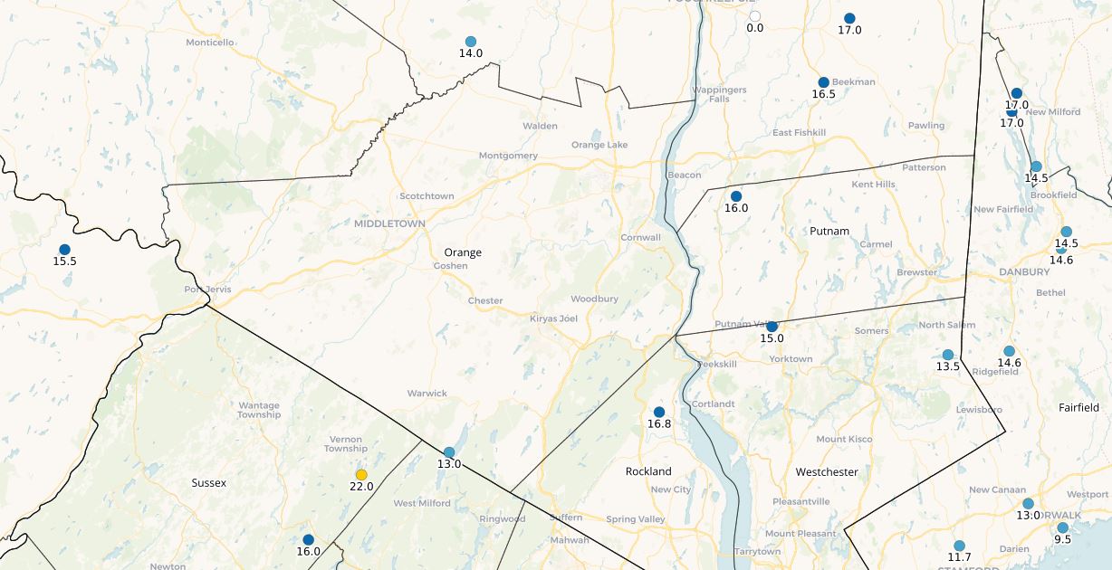
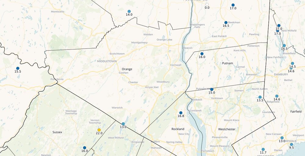
Central PA Winter 25/26 Discussion and Obs
ChescoWx replied to MAG5035's topic in Upstate New York/Pennsylvania
Plenty of single digit lows this morning with our lowest as is often the case in Warwick Township with a low of 3.8 above zero. Several degrees colder both today and Wednesday with highs in the upper teens with low temperatures in the colder valley locations near or below zero. Even colder air arrives on Thursday and Friday with widespread below zero readings and highs in the low to mid-teens. There will be a coastal low this weekend, but most model guidance keeps the impacts well east of the Philly burbs with snow possible toward the NJ shore points. That said there is still a possibility it will trend a bit closer to the coast and gives us some additional snow. Stay warm!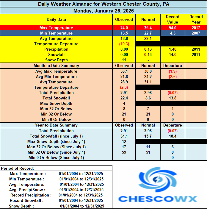

-

The “I bring the mojo” Jan 30-Feb 1 potential winter storm
BooneWX replied to lilj4425's topic in Southeastern States
Everyone down in the dumps and here I am browsing options at local Can-Am dealers -
I just did some google AI. Average us home’s roof can hold 20lb per square foot load. At a10 to 1 ratio, thats 38.5 inches of snow. So actually your point is valid if we get 2 more feet, assuming all of it is 10 -1 ratio.
-
Relevant to the ongoing cold: https://usicecenter.gov/Products/MidAtlanticHome
-
E PA/NJ/DE Winter 2025-26 Obs/Discussion
ChescoWx replied to LVblizzard's topic in Philadelphia Region
Plenty of single digit lows this morning with our lowest as is often the case in Warwick Township with a low of 3.8 above zero. Several degrees colder both today and Wednesday with highs in the upper teens with low temperatures in the colder valley locations near or below zero. Even colder air arrives on Thursday and Friday with widespread below zero readings and highs in the low to mid-teens. There will be a coastal low this weekend, but most model guidance keeps the impacts well east of the Philly burbs with snow possible toward the NJ shore points. That said there is still a possibility it will trend a bit closer to the coast and gives us some additional snow. Stay warm!