
All Activity
- Past hour
-
D0 ~ 20 miles from D4 is insane. Would make for an ideal spot to do some kind of drought research
-
Yea the clouds are thick and rolling in quickly. Has a tropical look to it.
-

Septorcher 2026 Discussion - Endless Summer
Ginx snewx replied to Damage In Tolland's topic in New England
COC weekend and as far as the weenie can see. -
Nothing severe here despite the warning. Could see the low clouds racing across the sky but winds never translated to the surface. Decent rainfall though with 0.35” from the fast-moving line.
-
Wind wise it’s not far off, but surge is a different story. A weaking cat 3 has imbedded surge while a strenthing cat 1 has yet to really form a large surge. .
-

2026 C and E Pacific tropical activity
LongBeachSurfFreak replied to GaWx's topic in Tropical Headquarters
Regardless of a direct hit on Kauai, there will be major coastal impacts. Lots of captured fetch and huge waves. Luckily the Hawaiin islands are used to large surf from the northern and southern hemisphere. . -
Yep. Could get more showers/storms but this is horrible timing.
-
Working out great for me! Thunder at 6am, lightning showing up now on the approaching MCS. Winning
-

2026 Mid-Atlantic Severe Storm General Discussion
AmericanWxFreak replied to Kmlwx's topic in Mid Atlantic
Don’t worry, HRRR says we get another one tomorrow! -
I thought it was going to miss me west but it seems it will get to my house within the hour
-

Septorcher 2026 Discussion - Endless Summer
WxWatcher007 replied to Damage In Tolland's topic in New England
1.64 since September 1 here at WXW1. -
Monday, August 31 - Thursday, September 3, 2026 Convective Episodes
WxWatcher007 replied to weatherwiz's topic in New England
I think this sums it up, folks. -

2026 Mid-Atlantic Severe Storm General Discussion
Eskimo Joe replied to Kmlwx's topic in Mid Atlantic
These repeated dying MCS's running into MD make me far more pessimistic that we get anything of substance below Mason-Dixon today. We're just working the atmosphere over too much.- 2,397 replies
-
- 1
-

-
- severe
- thunderstorms
- (and 7 more)
-
Frederick is Frederick’ing again. Another line incoming.
-
This week's drought monitor showed some more slippage in northern NC with an expansion for D3 and the reintroduction of D4 in the Triad area. Meanwhile the drought was again chipped away at the mountains and coast. Elsewhere in the south most areas remained unchanged but south of ATL has been dry lately and saw the reintroduction of moderate drought after a long break from it. Rest of Ga and SC were mostly unchanged
-
https://x.com/severeweathereu/status/2095419607100109295?s=46&t=dhcbvkjmRcyBVQtDxJ3lRg
-

2026-2027 Record-breaking El Nino
GaWx replied to Stormchaserchuck1's topic in Weather Forecasting and Discussion
The summer of 2026 ended up with the 2nd strongest summer -SOI back to 1876! Here are the 16 strongest -SOI summers. Note that while 1882 is way out of place with it being cold neutral, the rest are El Niños (with all but 1914 being moderate or stronger): 1896 (-22) strong 2026 (-21) progged super 1982 (-19) super 1882 (-18) cold neutral 1905 (-18) moderate 1997 (-17) super 1941 (-17) moderate 1940 (-16) strong 1987 (-16) moderate 2015 (-14) super 1965 (-14) super 1994 (-14) moderate 1914 (-14) weak 1977 (-14) moderate 1888 (-13) super 1972 (-12) super -
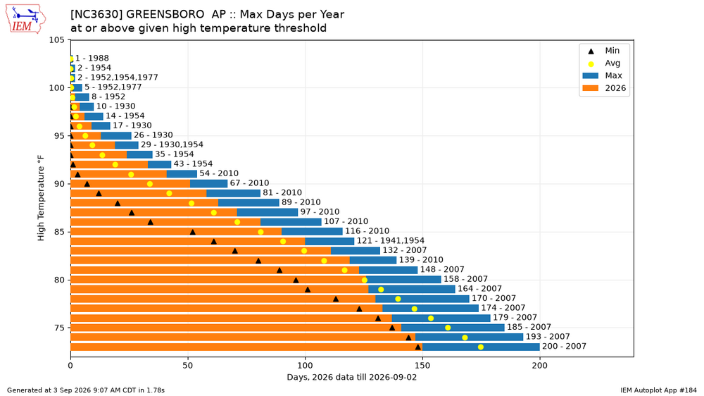
2010 was I think the hottest summer on record for Raleigh. I was in school at Clemson so I did not get to experience that here, thankfully
-
Just cloud cover and maybe some sprinkles, but that will knock down temps briefly until the weekend. It was the 3rd top 10 hottest Summer and 4th top 20 hottest Summer though within the past 5 years...
-
-
73 degrees and storming all morning here, hopefully this keeps the heat down later today.
-
.35" last night. Thought we were going to get a lot more based on the radar around midnight.
-
Yep. From ChatGPT: 2026 Raleigh Heat Metrics At-A-Glance (Year-To-Date) Days over 90°F: 65 days Days over 95°F: 33 days Days over 100°F: 6 days
-
STW through 10:30 a.m. for my yard. Radar indicated 60 mph wind gusts. Waiting….
-
u gonna get some of those remnants or is it duster days down there?












