All Activity
- Past hour
-

January 2026 regional war/obs/disco thread
weathafella replied to Baroclinic Zone's topic in New England
Gefs and geps concur with each other while the euro is a bit different in the long range. Either way, all have a cold reload quickly. I sure hope something comes out of the sky. Boring as hell right now. -
Id rather live in Worcester MA or somewhere in SNE with elevation because of the nor’easters. LES is cool but nothing beats the a good ol’ fashioned 20-30” coastal .
-

January 2026 regional war/obs/disco thread
moneypitmike replied to Baroclinic Zone's topic in New England
Good news/bad news Feeling a little like Phillip Rivers as I've been called out retirement. On the other hand, this requires me to be holding on to Pit 2 for at least a couple more years. Maine winters and Mattapoisett summers--things could be worse. Now that I think of it, if things play out well for Mattapoisett tonight, we might be getting close to Ray. j/k -
Works for me I’m sitting in central Delaware County only 30 minutes NE of Elkton Md. Cliff jump here no because we already had an amazing 6.5” postcard snow back on December 14th. My expectations for the amazing pattern and over hyped pattern on the models for 3 days was kept low, so come what may. Maybe I can get a snow squall between 4 am to 8 am tomorrow morning.
-
@stormtrackerwhat’s your ETA
-

-
You need to understand that lake effect is totally different between northwest Pa. and Phillidelphia. This is 2 totally different worlds!!!!!!!! Dear God! I thought your knowledge was advanced...................................
-

New Years Day 2026 - 1st snows of the new year possible
BrianW replied to Baroclinic Zone's topic in New England

-

January 2026 regional war/obs/disco thread
Go Kart Mozart replied to Baroclinic Zone's topic in New England
His constant inhaling of snot was annoying. -
Ah, Pulaski, Va. Haven't heard that town mentioned in many a year. Lived in Blacksburg, Va. for a while fifty years ago and visited the beautiful Cascade Falls area. Oh man talk about peaceful, that was a place. Snow can be pretty good in winter too, I remember once putting chains on my tires to get up a steep hill until I dared go no farther. https://gohikevirginia.com/cascades-falls/
-
I know where this is going for my yard if it amplifies...y'all could be in the game though!
-
The 18z AIGFS is straight up frigid. Let's continue to keep an eye on Jan 12th. If we can get that down to roughly 7 days, that may be a legit time to track something decent. That run had a decent snowstorm for middle and west. My main concern is this...if modeling, which has tended to under model cold fronts(exception Jan 2), then that cold could be stronger than shown.
-
Yep, although I'd prefer (as 90% would) snow, ANY moisture is welcome after the past few months, and I've been better off than many to the north and east.
-
The 5h trend is impressive. Going from a complete wall to a nice gap that could allow amplification is nice. TBH I was ignoring this one but will be paying attention now on out.
-

Central PA Winter 25/26 Discussion and Obs
Voyager replied to MAG5035's topic in Upstate New York/Pennsylvania
Looks to be about 0315 to 0330 if it holds together and is timed as depicted for my backyard. I'd love to be awake for it, but I don't know. Wife and I sometimes make it to midnight, but most times don't anymore (sucks getting old), so 0300 is going to be a push no matter what. I'd either have to try and stay awake, or set my alarm. -
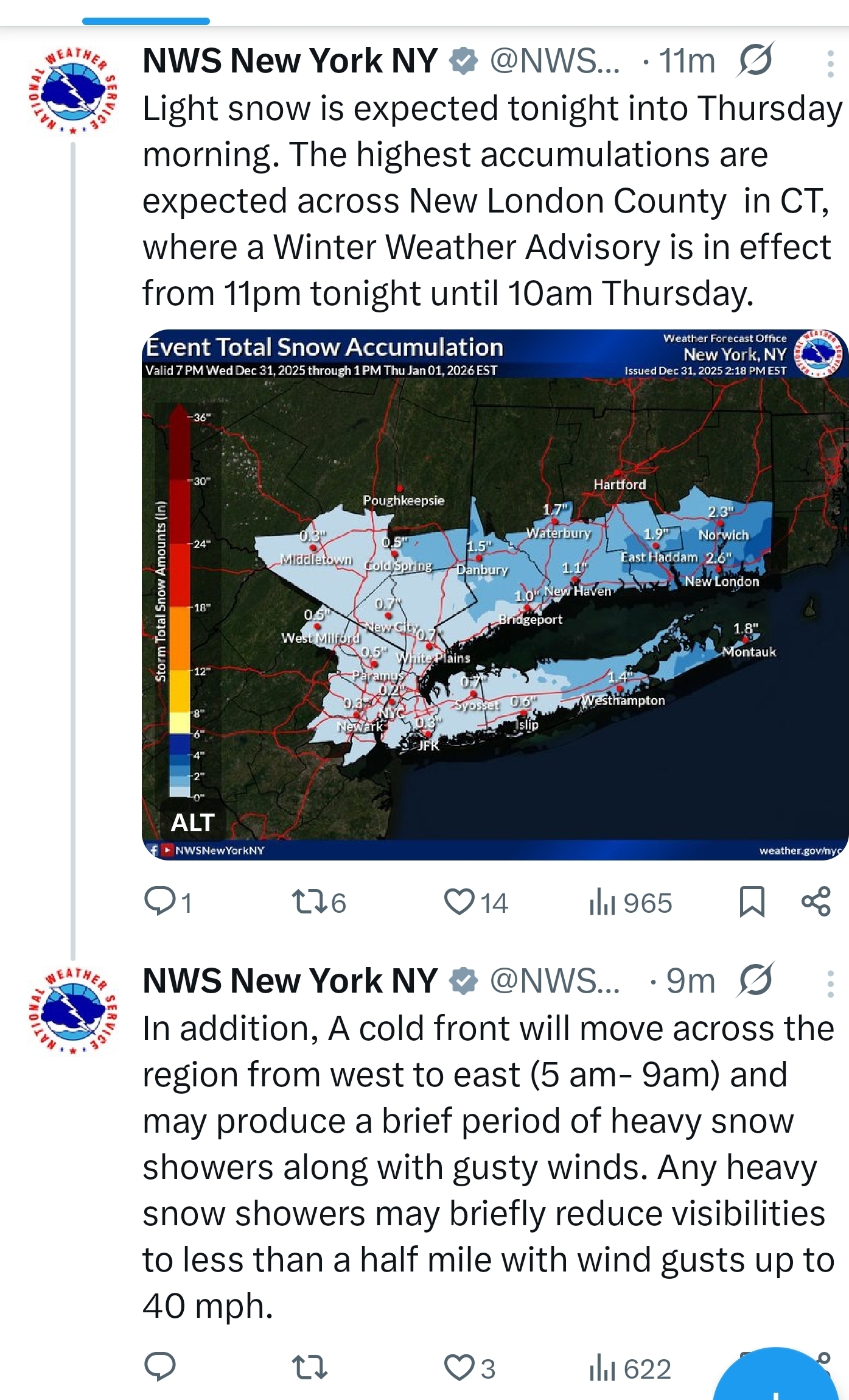
Some flurries or snow showers are possible tonight into tomorrow in parts of the region. The ground could be coated or dusted in places. The eastern end of Long Island and eastern Connecticut could see 1"-2" of snow due to an influx of some Atlantic moisture. The first week of January will likely have a mean temperature below 30° in New York City. The last time that happened was in 2018. The only years since 2000 with a sub-30° mean temperature for the opening week of January were 2001, 2010, 2014 and 2018. The ENSO Region 1+2 anomaly was -0.3°C and the Region 3.4 anomaly was -0.7°C for the week centered around December 24. For the past six weeks, the ENSO Region 1+2 anomaly has averaged -0.33°C and the ENSO Region 3.4 anomaly has averaged -0.68°C. La Niña conditions will likely continue into at least late winter. The SOI was +2.39 today. The preliminary Arctic Oscillation (AO) was -1.306 today. Based on sensitivity analysis applied to the latest guidance, there is an implied near 100% probability that New York City will have a cooler than normal December (1991-2020 normal). December will likely finish with a mean temperature near 33.9° (5.2° below normal). That will make December 2025 the coldest December since 2010 when the monthly mean temperature was 32.8°. It would also make 2025 the third coldest December since 2000. Supplemental Information: The projected mean would be 3.5° below the 1981-2010 normal monthly value.
-
-
Heading out soon for celebrations. Be safe if you’re out and about tonight. Here’s to a snowy start to 2026. Happy New Year weenies
-
 DCA _ NYC _ BOS _ ORD _ ATL _ IAH _ DEN _ PHX _ SEA +0.5 -0.4 -0.7 -0.4 +2.5 +2.2 +2.0 +1.6 +0.7
 -
Yeah, it depends on where you live. I grew up in a house built in the 1800s so there wasn't exactly a snow code for that roof.
-
I have not, so maybe one day I'll do it. I have a lifted Jeep, so it certainly wouldn't be a problem getting around.
-

January 2026 regional war/obs/disco thread
40/70 Benchmark replied to Baroclinic Zone's topic in New England
Probably from like Salem, NH northward. -
After all the numerous can kicks of the last 10 years, I sure hope so...goodness gracious. Yeah if we aren't seeing it move up in time by next week ya gotta wonder.
-

New Years Day 2026 - 1st snows of the new year possible
HoarfrostHubb replied to Baroclinic Zone's topic in New England
They plowed 2 different times we had 0.5” snows this season. But they seemed to have forgotten to put salt down They put some sand down which they haven’t in years. It sucks. -

12/31-1/1 Possible Snow Showers/Squalls to Start 2026
clskinsfan replied to bncho's topic in Mid Atlantic
Snowshoe gonna get pummeled. I really need to start chasing soon if nothing happens.