All Activity
- Past hour
-
GFS also sticking with the colder solution. If only it were a good model...sigh.
-
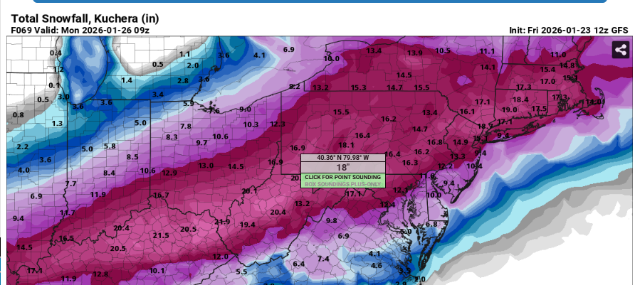
I agree in some ways, especially since no one’s complaining if we get a 2014 10-14” thump
-

Pittsburgh/Western PA WINTER ‘25/‘26
colonel717 replied to Burghblizz's topic in Upstate New York/Pennsylvania
-

Possible Record Breaking Cold + Snow Sunday 1/25 - Tuesday 1/27
NittanyWx replied to TriPol's topic in New York City Metro
Agree, what happens south of the Merrit and between 287 and 80 is still a big questionmark -
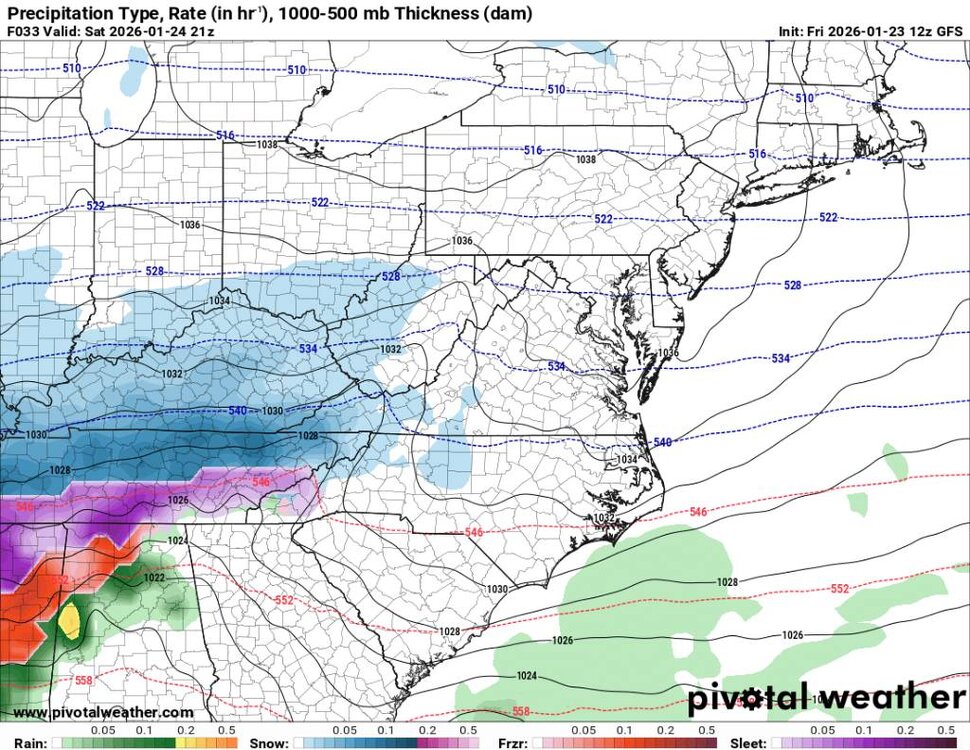
It does seem that we may stick with mixing a bit longer but the freezing rain potential is huge and severe. Sent from my SM-G998U using Tapatalk
.thumb.jpg.4a5f27a1c45d151aa29986d6e27fe35b.jpg)
.thumb.jpg.a2a48a84b1ac9abe24eecbe700a99dc2.jpg)
.thumb.jpg.a2b773afa79a60f34937c040882145cf.jpg)
.thumb.jpg.c7e7a3410e3fce7dd0920f75ecba73fa.jpg)
-

Possible Record Breaking Cold + Snow Sunday 1/25 - Tuesday 1/27
psv88 replied to TriPol's topic in New York City Metro
Models look great! Back to work -
Gonna hug the terrible GFS
-
Slight bump north and bump up ion QPF on GFS.
-

“Cory’s in LA! Let’s MECS!” Jan. 24-26 Disco
WxWatcher007 replied to TheSnowman's topic in New England
Man, this is a cold powder event for everyone away from the coast. Single digit temperatures to start. GFS has me getting beyond -30 tonight. Snowing near zero. -

Texas 2026 Discussion/Observations
Stx_Thunder replied to Stx_Thunder's topic in Central/Western States
Elevated wintry thunderstorms are looking pretty likely now in ETX (where it's most probable to occur), with lots of 850Mb - 700Mb WAA there. Euro is even showing unusually decent 850Mb instability from around Tyler area and south Saturday night. With lifted-index values down to -3. Definitely would not rule out a sig amount of CG lightning with those kind of instability values. Quite unstable and abnormal for this kind of Arctic airmass setup. This is looking to be similar to the post-frontal Arctic airmass convective event in the state back in March 2014. Where I even had some pretty strong storms in STX with substantial CG lightning activity that one night. Even though sfc temps were in the 30s. Which I had never experienced before. -

Possible Record Breaking Cold + Snow Sunday 1/25 - Tuesday 1/27
Stormlover74 replied to TriPol's topic in New York City Metro
Gfs basically stayed the same. A little less snow to the north but went up a bit south -

Possible Record Breaking Cold + Snow Sunday 1/25 - Tuesday 1/27
NEG NAO replied to TriPol's topic in New York City Metro
I don't have and don't want an X account - can't you start a thread here ? -

“Cory’s in LA! Let’s MECS!” Jan. 24-26 Disco
40/70 Benchmark replied to TheSnowman's topic in New England
I think they are for inside of 128. -

2025-2026 Fall/Winter Mountain Thread
calculus1 replied to Buckethead's topic in Southeastern States
GFS continues with a decent front end thump of snow in the mid to northern tier of western piedmont/foothills NC counties, including McDowell, Burke, Catawba, and points to their NE. I’m really hoping that verifies. Should be pretty to watch fall late Saturday afternoon/evening. -
 Some NYC area Mets are increasing totals for the city this morning. Others, like Tomer, are really down playing things and seem skeptical of even 6 inches in the city. https://x.com/MikeMasco/status/2014682599302607146?s=20
 -
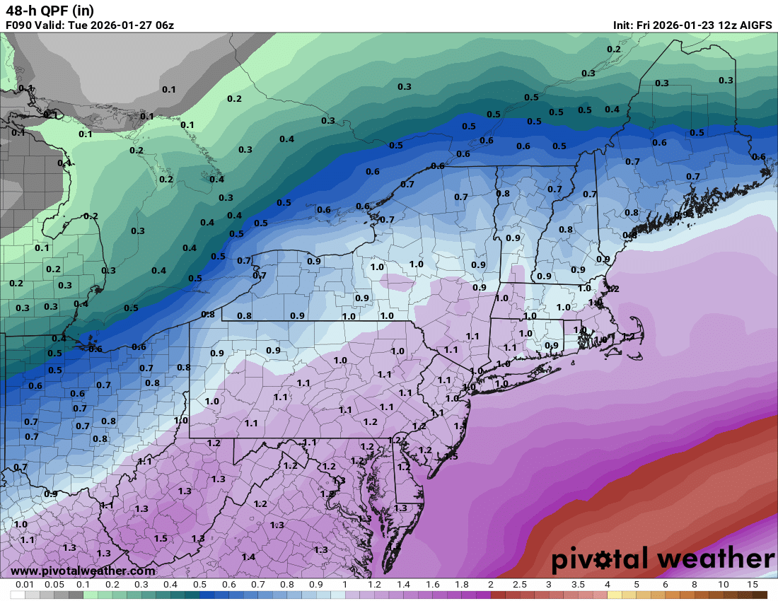
But this is an example of where I think AI is just broadly spreading QPF rather than honing in on details. That’s a lot more QPF in NNE vs deterministic models and less in SNE.

-
I think we want it to amp early. The low is way way west of us. Toggle the full us map at 39. That stream of overrunning is what we want and not some disjointed flat system. If it’s flat it sends the best early stuff south and we wait for the second and that comes with the warmth.
-

“Cory’s in LA! Let’s MECS!” Jan. 24-26 Disco
Baroclinic Zone replied to TheSnowman's topic in New England
GFS slay -
Yeah that was somewhat similar as far as amounts go but this looking significantly bigger and much longer duration. Not mention the cold after this one is long lasting. So no melting really at all.
-
“Cory’s in LA! Let’s MECS!” Jan. 24-26 Disco
40/70 Benchmark replied to TheSnowman's topic in New England
Told you yesterday there was a limit with PV pressing, west NAO block and 50/50 low. -
12z GFS gets heavier precip in quicker- nice thump
-
GFS ups Ice totals for the valley some
-

January 24-26: Miracle or Mirage JV/Banter Thread!
Interstate replied to SnowenOutThere's topic in Mid Atlantic
I wish NE had home field advantage in the playoffs... That would have been a fun game to watch. -

Possible Record Breaking Cold + Snow Sunday 1/25 - Tuesday 1/27
SACRUS replied to TriPol's topic in New York City Metro
-


.jpg.bd9bfa99771a8d88488b03178ecd5efe.jpg)
.jpg.ccdd8d779188e6fab8fafe69aa6d5104.jpg)
.jpg.ca8742889562ff35db20c078a7c57153.jpg)
.jpg.425061352263c7c6c873d4888d9fcea2.jpg)