All Activity
- Past hour
-
Pretty wild that coastal Georgia will see more snow than us at this rate.
-

2025-2026 ENSO
donsutherland1 replied to 40/70 Benchmark's topic in Weather Forecasting and Discussion
Yes. It has been uneven. Then again, it hasn’t been a strong La Niña event. -
And how does that make you feel? Your internet followers are getting kind of obnoxious and disrespectful and disruptive to your page. That must suck huh?
-

Winter 2025-26 Short Range Discussion
cyclone77 replied to SchaumburgStormer's topic in Lakes/Ohio Valley
Missing to the east by <5 miles lol -
Someone get that man another cup of espresso !
-
How is north ga looking? I can’t see any maps.
-
RAH pretty aggressive for that office: 00z GFS and ECMWF depict a more vigorous shortwave that swings across the Southeast US and Carolinas on Sunday, with a surface cyclone that develops off the coast of the Carolinas and moves NE. With very cold temperatures aloft by this point (and Sunday`s surface temperatures staying in the 30s at least based on the latest raw guidance), any precipitation that falls over central NC is likely to be snow, but the question is how much precipitation (if any) we actually receive. The GFS is sharper with the trough aloft compared to the ECMWF, resulting in snow across a larger portion of the area compared to the ECMWF which is more focused in the east. Regardless, considering nearly half of ECMWF ensembles and over half of GFS ensembles depict accumulating snow across the area, it bears watching. WPC QPF is light at this time but could increase if models converge on a surface low track closer to the coast.
-
12z will be interesting!!
-
I personally think we will get another shot at snow this winter but mother nature certainly has shown her hand. If nothing happens in January this place will be beyond readable...should be fun
-
EPS uptick at 6z was pretty drastic! Very good look this morning
-

January 2026 regional war/obs/disco thread
40/70 Benchmark replied to Baroclinic Zone's topic in New England
Take a look at this event....Sunday night is a toned down version, but it happens...accept and deal. -

Winter 2025-26 Short Range Discussion
A-L-E-K replied to SchaumburgStormer's topic in Lakes/Ohio Valley
Yeah currently ripping probably best rates of the season with the insta-dab -
HGR is in its worst 4 year period for snowfall since records have been kept there. (1899) It's been really really bad.
-

Winter 2025-26 Short Range Discussion
DocATL replied to SchaumburgStormer's topic in Lakes/Ohio Valley
Heavy duster in Naperville. Winter is here! -
We're at 39 degrees latitude. With next to no elevation. It's kind of surprising it ever snows at all.
-

January 2026 regional war/obs/disco thread
Kitz Craver replied to Baroclinic Zone's topic in New England
I don’t think WOR has any chance, you may however -
You are not wrong in this assessment. We truly have been in a terrible slump and there's no end in sight unfortunately. It reaffirms my notion that without a favorable Pacific, our snow odds are likely killed in the cradle.
-

January 2026 regional war/obs/disco thread
Damage In Tolland replied to Baroclinic Zone's topic in New England
If Sunday hits it would snow here . Those type of events never snow for ORH and not here . I’m not counting on anyone getting it -

2025-2026 Fall/Winter Mountain Thread
strongwxnc replied to Buckethead's topic in Southeastern States
Might take the family up and out of the foothills on Saturday. What would be a good spot to ride around, through and maybe sled a little? Cause it will be all brown down here -

Central PA Winter 25/26 Discussion and Obs
mahantango#1 replied to MAG5035's topic in Upstate New York/Pennsylvania
Hopefully we get our paralyzing snowstorm. -

January 2026 regional war/obs/disco thread
CoastalWx replied to Baroclinic Zone's topic in New England
Taste it -
For what feels like the 300th time since Christmas we had a non-diurnal temp event here overnight. Temp was 33.0 at 10 pm, then slowly climbed to the current 36.4/25.8 at 7 am. In and out of clouds overnight, windy/gusty SW winds after midnight (28 mph gust).
-
Should be a fun one tonight especially North of I-40. Models show a more real shot for Saturday into Sunday. Might be our best shot this season but I don't want to jinx it. Seems like every time I make a post about a storm in here it disappears lol. Looking at the 6z GFS and a phase 6 hours before would give a big time snowstorm to us on Saturday and into Sunday. Euro is also showing it. We just need that trough to steepen up just a bit and the moisture will flow into WNC. Anyways, stoked to see how some of you folks do tonight, hoping for a dusting -1" at my house while 2 miles away Craggy gets 4"-6".
-
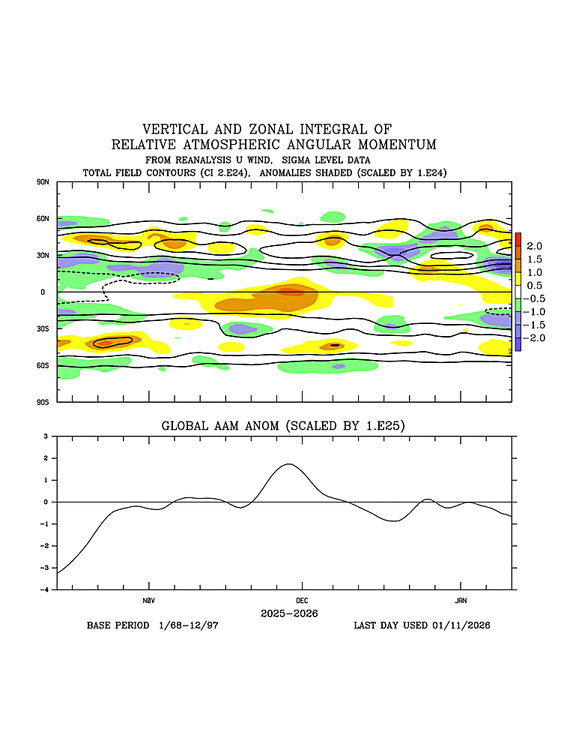
I would say the atmospheric coupling with the La Nina event has been uneven. The AAM has averaged near neutral since Nov, with a notable spike from late Nov to the first few days of Dec. I agree with your last three sentences about La Nina's continued influence in the next month or two. Also, in my experience, the CFS is known to be highly +AAM biased.
-
The eps ensembles took a severe snow map Hit last night


