All Activity
- Past hour
-
Wow you're not kidding. Just got some pretty decent gusts all of a sudden. Guessing we must have just reached ~850mb for mixing level.
-

Central PA Spring 2026 Discussion/Obs Thread
canderson replied to Voyager's topic in Upstate New York/Pennsylvania
72 and haze sunny at noon -
Only of he quits. Lol
-
Another great day out there. In the "bad" pattern lol
-
-
-
61° here. It feels like 81° after what we've been having.
-
Not for me
-
Last week was Mother Nature cracking up at us.
-
56/32 FEW Not a bad day out there although there’s some rogue good gusts at times.
-
Smoke is visible in this area due to the S GA fires.
-
why? i understand winter is your thing but constant grey 50's with rain and wind is just gross
-
I would live in Thule, Greenland and eat fermented whale blubber all day before I’d live down there.
-
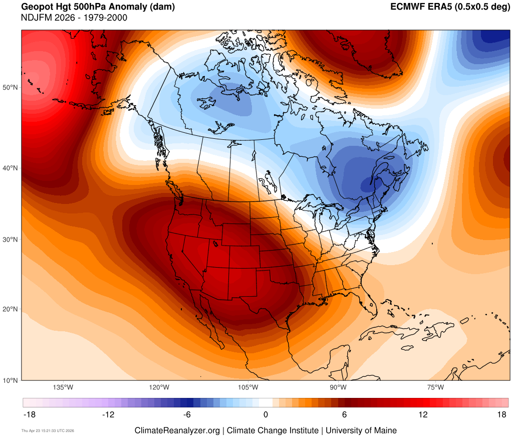
Probably not. This year is probably the polar of 2020. That year, we had an ending weak +ENSO that transitioned into a solid la nina, and a developing -PDO. This year, we have an ending weak -ENSO that looks like it's transitioning to a strong, if not super, el nino, and an ending -PDO/developing +PDO. Plus, 2019-20 was a very warm and virtually snowless winter that turned cold in April into May, while this winter was cold and snowy, that turned warm in March, and flipped to a torch around Daylight Saving Time.
-
63 and bluebird sky. Beautiful day!
-
Ha ha ha that’s all right. I knew I was going to incur the wrath just by bringing it up.
-
Music to my ears
- 804 replies
-
- 1
-

-
- april showers bring may..
- rain
- (and 2 more)
-
Want to switch ?
-
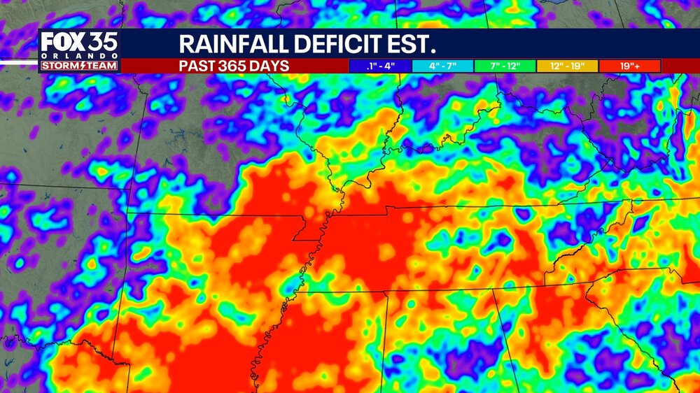
Found this on FB from a local news station in Orlando showing 365 day rainfall deficits. I found it very interesting that the location of the August 2025 flash floods over eastern Hamilton county is very apparent. That was the only significant rainfall in this corner of the state for months.
- Today
-
Yep it is bad throughout the Southeast.
-
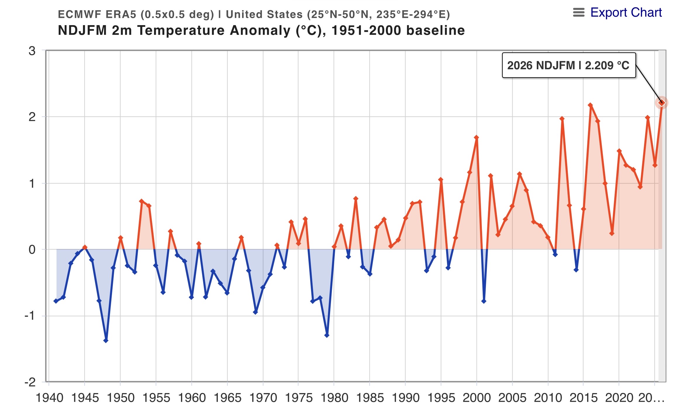
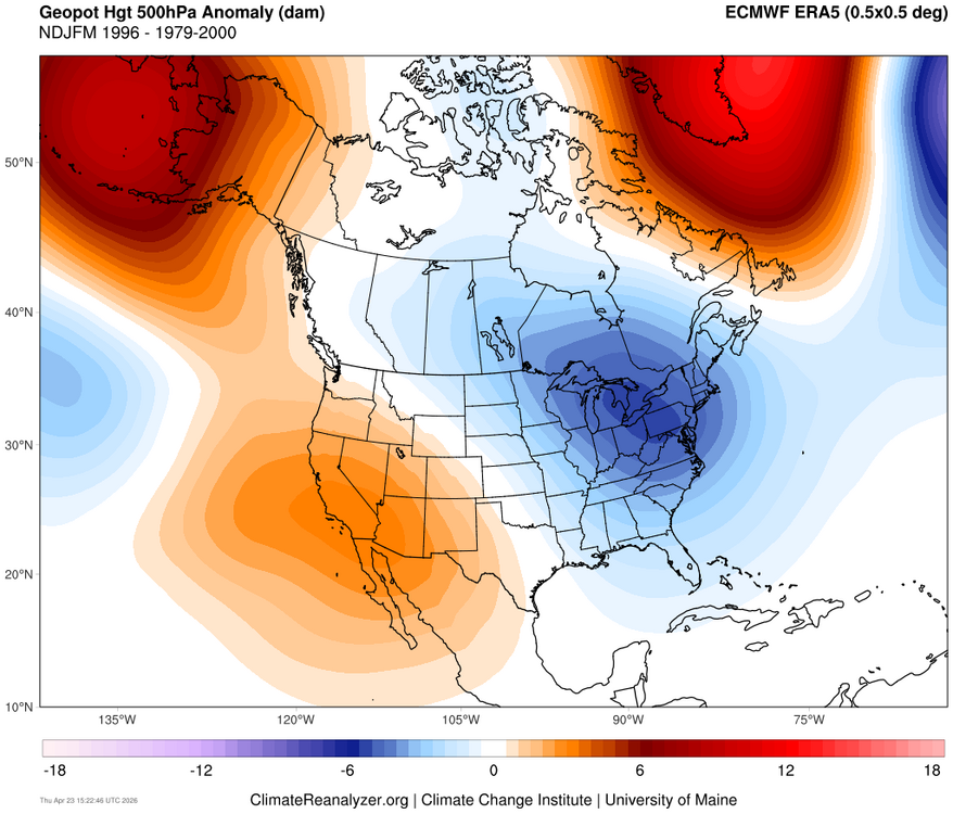
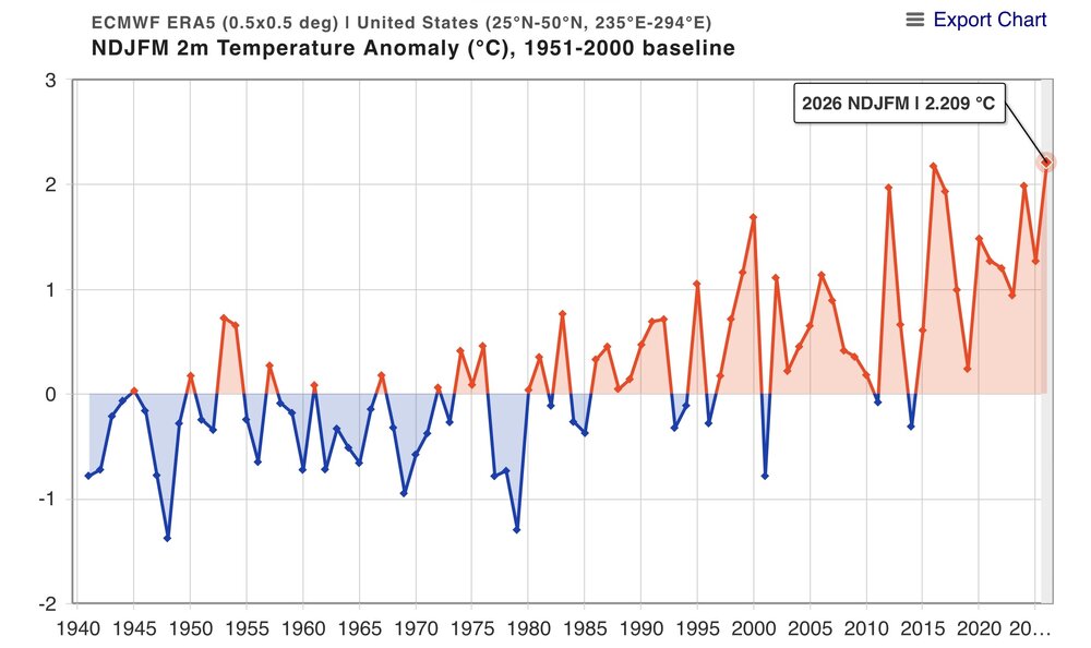
There are a few ways of looking at this. If you use a linear model, then you would be correct. But a non-linear process involving threshold temperarures of marine heatwaves potentially driving the forcing leading to that record breaking ridge would be a different case. The ridge out West was much stronger from November to March this year than the similar weak La Niña in 1995-1996. Such an increase could be the result SST forcing thresholds being met and the pattern becoming much more amplified and locking in over a longer duration. So rather than a gradual increase in temperatures and 500mb ridging, the warmer background pattern resulted in more of a jump. The CONUS was actually slightly colder in 1995-1996 instead of the warmest November to March on record in 2025-2026. There wasn’t the extended record warmth out West over the same period back in 1995-1996. https://agupubs.onlinelibrary.wiley.com/doi/full/10.1029/2022GL101499 Circus Tents, Convective Thresholds, and the Non-Linear Climate Response to Tropical SSTs Using model simulations, we demonstrate that the climate response to localized tropical sea surface temperature (SST) perturbations exhibits numerous non-linearities. Most pronounced is an asymmetry in the response to positive and negative SST perturbations. Additionally, we identify a “magnitude-dependence” of the response on the size of the SST perturbation. We then explain how these non-linearities arise as a robust consequence of convective quasi-equilibrium and weak (but non-zero) temperature gradients in the tropical free-troposphere, which we encapsulate in a “circus tent” model of the tropical atmosphere. These results demonstrate that the climate response to SST perturbations is fundamentally non-linear, and highlight potential deficiencies in work which has assumed linearity in the response.

-
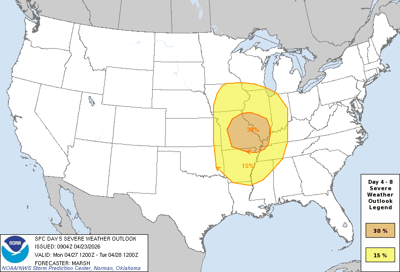
Very large warm sector with much of the western sub highlighted in the 15% for Day 5, Monday 4/27
-
That's why people go to Florida and come back here in May...
-
Well, it was a pretty memorable and spectacular VD Day melt 2007... triggered by the sudden epiphany that that particular snowfall, that night would never live up to expectations due to the inability of the mid levels to cool the .00000001C needed for the sleet to abate. #neverforgetchristine
-
April 23 1990: A record high of 88 degrees is set at Redwood Falls. For Thursday, April 23, 2026 1885 - The city of Denver, CO, was in the midst of a storm which produced 23 inches of snow in 24 hours, and at Idaho Springs CO produced 32 inches of snow. (David Ludlum) 1910 - The temperature at the Civic Center in Los Angeles, CA, hit 100 degrees to establish an April record for the city. (The Weather Channel) 1983 - A mini-blizzard produced sixteen inches of snow at Laramie, WY, including a foot of snow in just eight hours during the night. (The Weather Channel) 1987 - Thunderstorms in the Atlantic Coast Region produced golf ball size hail and wind gusts to 67 mph at Anderson SC. The high winds destroyed two planes at the airport, and the large hail damaged fifty other planes, and severely damaged twenty-three greenhouses. (The National Weather Summary) (Storm Data) 1988 - An intense winter-like storm brought thunderstorms to southern California, and produced snow in some of the higher elevations. Nine girls at Tustin CA were injured when lightning struck the tree under which their softball team had taken shelter from the rain. (The National Weather Summary) (Storm Data) 1989 - Salina, KS, was the hot spot in the nation with a high of 105 degrees. The high of 105 degrees established an April record for the state of Kansas. A total of eighteen cities in the central U.S. reported record high temperatures for the date. (The National Weather Summary) (Storm Data) (The Weather Channel) 1990 - Thunderstorms produced severe weather in West Texas and western Oklahoma. Thunderstorms produced tennis ball size hail at Lake McKenzie TX and at Garden City TX, and produced wind gusts to 90 mph at Gage OK. Thunderstorms drenched southeast Minnesota with heavy rain, with 6.6 inches reported northwest of Browndale. High temperatures were mostly in the 80s across the central U.S. The morning low of 67 degrees at Fargo ND and afternoon high of 91 degrees were both records for the date. (Storm Data) (The National Weather Summary)

.thumb.gif.f92b16c631a1d15d405ed77b33f0710d.gif)