All Activity
- Past hour
-

November 2025 general discussions and probable topic derailings ...
dendrite replied to Typhoon Tip's topic in New England
Currently 32.3° with some snow melting. Min was 29° shortly after midnight. -
This is unbelievable. Thank you for doing this.
-

December 2025 Short/Medium Range Forecast Thread
Carvers Gap replied to John1122's topic in Tennessee Valley
The difference between 0z and 6z on the GFS is stark regarding the long range pattern. I think it likely we deal with warm temps through the first week of December, but that is not set in stone as there is a cold front possibly coming through Dec 6th(up in the air so to speak). -
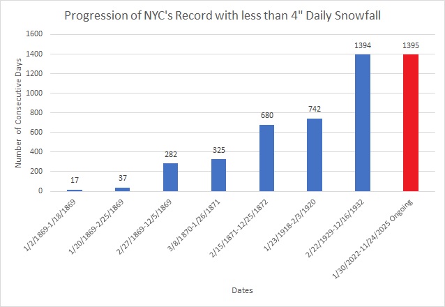
Today will be New York City's (Central Park) 1,395th consecutive day without a 4" (10.2 cm) or above daily snowfall. That will break the record of 1,394 days that was set during February 22, 1929 through December 16, 1932.
-

November 2025 general discussions and probable topic derailings ...
Kitz Craver replied to Typhoon Tip's topic in New England
EURO and GFS going for a coastal around the 5th. I believe Ray said chance of one around that period -

2025-2026 ENSO
Stormchaserchuck1 replied to 40/70 Benchmark's topic in Weather Forecasting and Discussion
Dec 2021 was one of the strongest -PNA's.. what I see on models right now is a "moderate -PNA event" in early Dec. I also don't know that it sustains beyond like a week. We'll see. If it lasts into mid-December that would be a little different from what we have seen this year (where -PNA's last 7-10 days then go away). -
Boston, MA - 53” NewYork, NY(Central Park) - 27” Philadelphia, PA - 21” Baltimore, MD- 16” Washington, DC- 13” Albany, NY- 65” Hartford, CT - 61” Providence, RI- 40” Worcester, MA - 71” Hyannis, MA - 33” Burlington, VT - 93” Portland, ME- 75” Concord, NH - 69”
-
@Stormchaserchuck1 It looks like the record +PNA streak is finally about to come to an end. The ensembles (EPS, GEFS, GEPS) have the most negative long range PNA forecast I’ve seen in a very long time….years in fact
- Today
-
2025-2026 ENSO
Stormchaserchuck1 replied to 40/70 Benchmark's topic in Weather Forecasting and Discussion
I'm not going to bet you money, maybe another time, but I will bump this on Dec 14. I don't think you're going to get that snow. -
@Gawx Just looked at the new ECM zonal wind forecast, this is looking like almost a sure bet for a classic wave reflection event with a rapid recovery and strengthening of the SPV in December
-

Fall 2025 Medium/Long Range Discussion
A-L-E-K replied to Chicago Storm's topic in Lakes/Ohio Valley
Weekend duster starting to dab out and extended losing the sauce, sad -

Central PA Fall Discussions and Obs
Voyager replied to ChescoWx's topic in Upstate New York/Pennsylvania
Good temp inversion this morning. 31 at my house and 38 up in Hazleton which is 1,000ft higher than Tamaqua. -

Fall 2025 Medium/Long Range Discussion
sbnwx85 replied to Chicago Storm's topic in Lakes/Ohio Valley
I know @Chambanais pulling hard for the 00z Euro. -
-

Fall 2025 Medium/Long Range Discussion
cyclone77 replied to Chicago Storm's topic in Lakes/Ohio Valley
Looks like it'll take another day or two to work out the fine details with this lead wave. Lots of moving parts. The large scale pattern really does support a high-end storm evolving out of this immediately following the lead wave. Hope we can sync things up properly to take advantage of it. -
Still hovering just above freezing here.
-
I haven't looked at the UKMET in a while. The 0z is also significantly divergent from the (hideous) GFS as early as day 5 and pretty cold at the end of its 7 day run. It actually tries to get some snow into our area on Sunday with the weak in-between shortwave. Other guidance has this feature very weak or further north. I'm happy with any model run that doesn't send repeated cutoffs to CA. I'd love to see the ECM and EC-AI move away from the southwest cutoff at 0z.
-

December 2025 Short/Medium Range Forecast Thread
jaxjagman replied to John1122's topic in Tennessee Valley
Still look like its getting into Africa before Christmas
.png.bc299553c890ff9901eb6530194a8570.png)
-
A measured 1.5 at 1850’ at 11pm from the clipper. Lull from 10pm on, but starting to pick up slightly as the upslope takes over. .
-
I usually do not post in this forum but I feel for you guys too. AS I said a few days ago in the Philly forum: Where the hell these long range so called weather gurus snow weenies seeing snow for our area on facebook and other media sources and who are just trying to make a few advertising bucks playing up the polar vortex bs but the current models are sure are NOT portraying anything like this right now for our area.. Every single snow chance has now dwindle to rain/mix event and also an insignificant rain event at best for our area as the cold dry air is winning the battle. The models have shown only one positive thing in the last two weeks for a major pattern change and a possible major snow event for us but when it will ever occur will just be plain luck. If you old timers recognize the current major pattern shift on the last weeks runs which we have not seen in nearly 6-10 years is identified as the four corner lows which are developing and pushing into the Gulf of America. Then these lows are quickly re-energized with a ton of moisture and are setting up for a good Miller A type of storm event- rain or snow along the east coast. The lows south of New Orleans into Tampa are impressive on the model runs. This is the best look in model runs in a long time as it appears the GOA is opening back up for business, however these low pressure systems are also quickly becoming southern sliders too. The cold dry air that does come through with a cold front is NOT retreating back up into Canada so quickly before the moisture reaches us. Would not be surprised if the Carolina's up to Washington DC sees more accumulating snow then us this year. This pattern is slowly setting up for a lot nuisance mix storm events snow/sleet to rain for our area if this keeps up. A pure snow event will be hard to come by in the next few weeks I basically want a 2-4 in long duration three day rain event asap to get the trees feet wet before the ground freezes and to get runoff back into the soon to be dry streams. Trout fishing and landscaping this spring will be severely hampered too if you do not get some significant rains in the next 2-3 weeks. When LCA declares a drought watch folks,its pretty serious. I have USGS gauging stations in my backyard for the Little Lehigh and if this stream dries up, the businesses will be greatly affected too throughout PA Quote
-
My area has so many snow holes in the historical record but now I know whenever I’m feeling down at WXW1 I can look at this…
-
At 12z the CMC and GFS were in decent agreement all the way out to day 7. Now at 0z they suddenly diverge pretty significantly as early as day 5. They've kind of switched places with the GFS suddenly much deeper and further southwest with a mature ULL meandering through CA and the CMC moving away from that look towards a more positively tilted and further east trof. The take home message is that this is a period of high model volatility. It probably doesn't matter much because either way we're too far from the cold air (through the mid-range) until the moisture is gone. I prefer the CMC look, however. It keeps us a little closer to the goods. I despise the deep ULLs burying themselves in CA , which are really hurting our chances.
-
Fall 2025 Medium/Long Range Discussion
sbnwx85 replied to Chicago Storm's topic in Lakes/Ohio Valley
The system Saturday is weaker and south. Then a cutter with rain which seems inevitable no matter what happens Saturday. -
Now we get to watch the models do their back and forth dance. GFS looks yuck with a stronger ridge, Canadian looks better.
-
Wow, amazing! Thanks for all the hard work!


.thumb.png.4150b06c63a21f61052e47a612bf1818.png)