All Activity
- Past hour
-
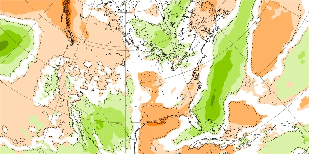
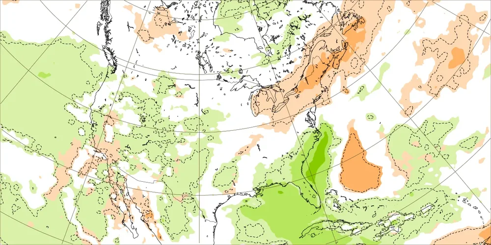
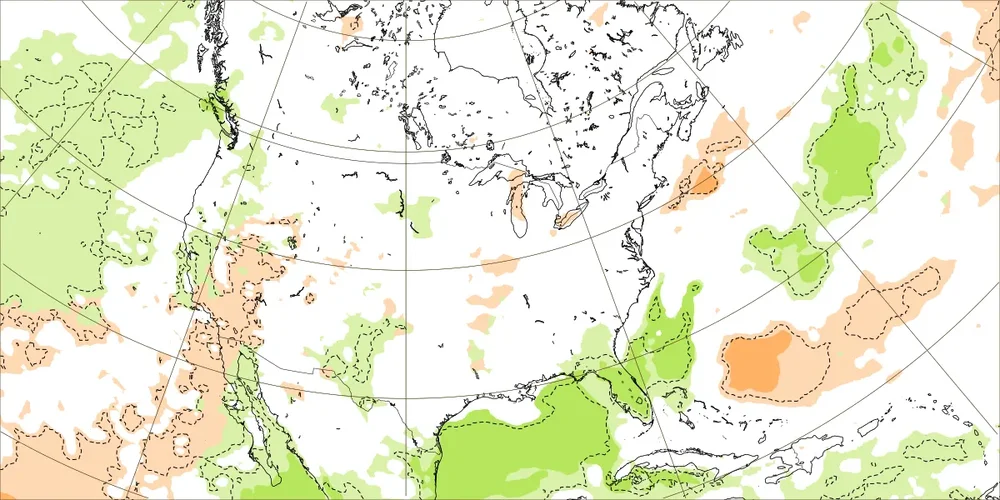
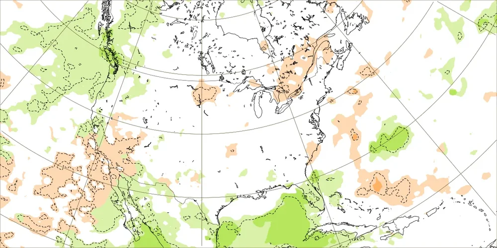
That’s a WxBell version of yesterday’s Euro Weeklies that covers 8/28-9/26 of 2025. I prefer to look at the output from the source, itself, ECMWF, as some WxBell maps are of questionable accuracy due to their algos: 9/1-7: slightly BN coastal MA (tan 1st shade is within 10 mm BN or <0.4” BN) and NN inland MA and all of NE 9/8-14: NN MA, slightly BN much of NE 9/15-21: NN 9/22-28: NN These 4 weeks don’t look as dry as the WxBell 30 day map implies. @mitchnick
-
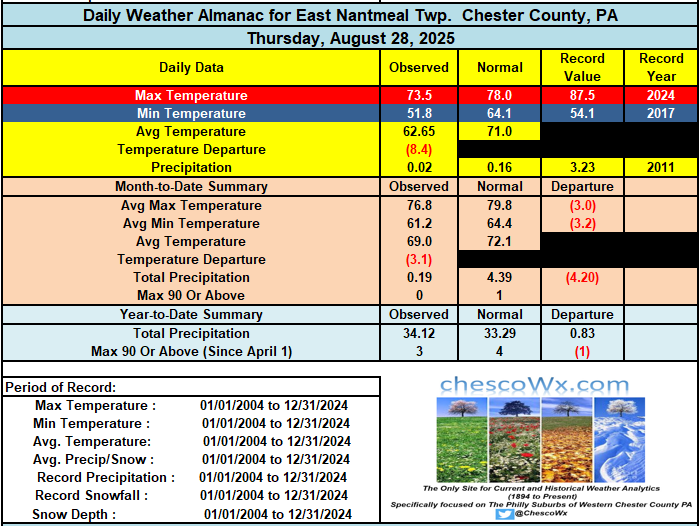
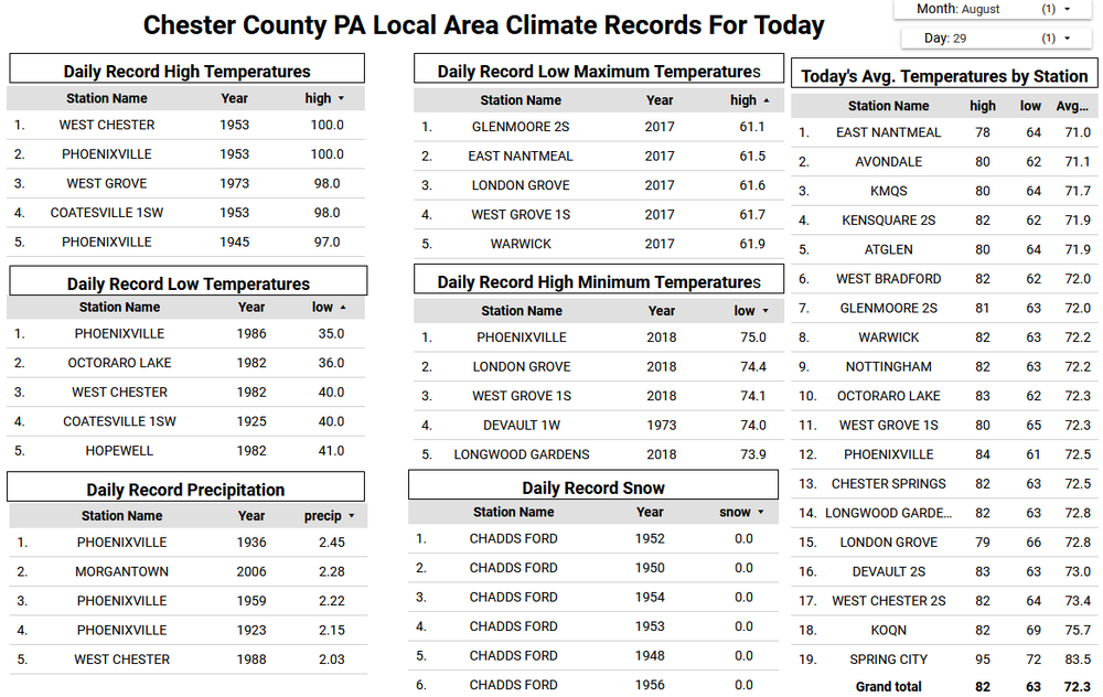
Our run of dry and unseasonably cool weather looks to continue through at least the next week. Another cold front is crossing the area today and by later today winds will turn to the west, northwest, and become gusty. Dew points will fall into the 40's by evening and actual air temperatures will likely follow with widespread lows by Saturday morning in the chilly 40's. Some of our usual colder lower valley spots may be in the low 40's with even some 30's not out of the question. Some higher spots may not escape the 60's for highs tomorrow afternoon. Rain chances look low for much of the week before some chances of rain creeping back into the forecast by Thursday.
-
I don't see much to get excited about honestly. ENSO doesn't look inspiring and and the PDO region is bathwater right now. I'm not pessimistic like having a wall to wall disaster but my early guess is lining up cold air AND precip won't come easy. The optimist side of me is thinking that we will have some patterns that lock in some cold air for periods long enough for some real chances at winter wx. How things mix together is impossible to know at any range really. Overall my gut is feeling pretty ho hum based on history and playing this silly game for the last 20 years. Ma Nature is a complicated and unpredictable lady though. The rubber band will bend our way again. Your guess is as good as mine as to when lol. Would be nice to enter met winter with a BN Atlantic. Dec has real hard time working when a large parcel warm along the coast. That's doesn't look hostile right now but we have a long way to go before understanding that piece.
-

E PA/NJ/DE Summer 2025 Obs/Discussion
ChescoWx replied to Hurricane Agnes's topic in Philadelphia Region
Our run of dry and unseasonably cool weather looks to continue through at least the next week. Another cold front is crossing the area today and by later today winds will turn to the west, northwest, and become gusty. Dew points will fall into the 40's by evening and actual air temperatures will likely follow with widespread lows by Saturday morning in the chilly 40's. Some of our usual colder lower valley spots may be in the low 40's with even some 30's not out of the question. Some higher spots may not escape the 60's for highs tomorrow afternoon. Rain chances look low for much of the week before some chances of rain creeping back into the forecast by Thursday. -
Since it hasn't begun raining here yet, we've had only the ditty's 2 days of rain this month, though not on consecutive days. Too young to have seen Johnny Sain pitch, but Spahn was a favorite with the big kick, deadly pick-off move and the best screwball since Carl Hubbell. His 16-inning duel with Juan Marichal at age-42 might be the best such game since the dead ball era.
-
I was afraid wxfella or tamarack were going to have to save me on that one.
-
Summer 2025 Medium/Long Range Discussion
TheClimateChanger replied to Chicago Storm's topic in Lakes/Ohio Valley
How did this work out? Akron, Ohio was supposed to get 3.5" of rain from the "biblical storm" and 4-5" over the 2 weeks. Instead, it will be the driest month on record - not just the driest August, the driest of ANY month. -
-

Central PA Summer 2025
Mount Joy Snowman replied to Voyager's topic in Upstate New York/Pennsylvania
Here's a new one......national low of 27 near Big Bay, MI. Looks like a ULL feature could control our weather late next week through the weekend, and then a possible warmup after that. Onward. -
I haven’t blocked him for the entertainment value. His forecast is the exact same literally every single year without fail for the past 20+ years. “Severe cold and snow in the east from Thanksgiving until New Year’s”. You can set your watch to it, wash, rinse, repeat
-
It took me a minute to pull that one from the back of my mind. .15" and still raining here. Would like to have it hang around a bit but at this point anything is nice to have.
-
Looks like most showers today on a line from Boston down to SE CT and east
-
Extending the nice weather into fall will be so amazing! I can't believe this August has been so delightful. It's like we live in Southern California all of a sudden.
-
Summer 2025 Medium/Long Range Discussion
madwx replied to Chicago Storm's topic in Lakes/Ohio Valley
going to get a nice cool blast later next week into the weekend, even cooler than what we've had this past week. After that maybe some upper level shuffling occurs and a SE ridge forms again, giving us more SW flow and mild temps -

Texas 2025 Discussion/Observations
Stx_Thunder replied to Stx_Thunder's topic in Central/Western States
TX Summer 2025 heat/humidity is looking more likely now to come to an abnormally early halt after Labor Day weekend as fronts will start to surge through most, if not all the state (even into STX). Along with more statewide convective episodes, initially at least. Aside from temp evidence this week in the plains/midwest, signs of a very early season frontal passage in the state was already there since the start of August. Which had an abnormally deep north flow pattern aloft across the state that did reach 45 knots at H5, on DFW upper-air obs 0Z data August 5th. And the AO is trending back into negative phase to start September. Euro and even GFS and Canadian now are all starting to latch onto an actually comfortable cooldown with well below normal daytime highs only around 70 F a possibility in NTX on September 5. Will definitely be interesting to see how cool & comfortable things actually get across the state later next week. Especially just barely coming out of meteorological summer! -
I thought it was posted more because Snowman agrees with his suggestion of an uptick in tropical activity would be no surprise, MJO going into favorable phases and not warmer maritime phases, and the cold coming between Thanksgiving and Christmas.
-
Storms a poppin just north of Boston
-
should be. I'm hoping it stays just like this for the 6th too
-
Only your favorite since you are the only one who brings him up. That post has 4 comments btw. It shows no one cares.
-
58 for the low in Fuquay Varina this morning. Made it up to 82 yesterday for the high.
- Today
-
Guessing it will be almost ideal by August standards for the PSU kickoff tomorrow? Sounds like it couldn't be a better football day this early in the season.
-
Just noticed everyone’s favorite met tweeted the EURO 30 day QPF map
-
Another fantastic fall like morning here in the valley! Cool and some clouds for the win, a great treat after the terrible heat It must be my Irish roots, I should live in the PNW or do the vampire thing and live at night
-
So far the cool week has not exceeded last weeks -8 to -11 departures 8/20 - 8/21 EWR: 8/26: 83 / 65 (-1) 8/27: 79 / 61 (-5) 8/28: 80 / 57 (-6) NYC: 8/26: 79 / 63 (-4) 8/27: 75 / 61 (-7) 8/28: 78 / 61 (-5) LGA: 8/26: 80 / 65 (-4) 8/27: 76 / 63 (-6) 8/28: 79 / 64 (-4) JFK: 8/26: 85 / 63 (0) 8/27: 77 / 63 (-4) 8/27: 8/28: 76 / 60 (-6)

