All Activity
- Past hour
-

2026-2027 Super El Nino
raindancewx replied to Stormchaserchuck1's topic in Weather Forecasting and Discussion
The PNA is negative to barely positive in July in a lot of the big El Ninos on this data set. https://psl.noaa.gov/data/correlation/pna.data 2023: +0.65 2015: +0.29 1997: +0.10 1982: +0.49 1972: -1.13 July was negative in 2018, 1963, 1965, 2004, etc along with 1972 Was also negative in Aug 1997. -
 Oh trust me, I know. That area can torch right into the western Dakotas. But they did another record yesterday with 107F. They were +6.9F MTD before today and they put up another 100+ today. The 9th 100+ of the month.
 -
Interesting. Sub-tropical or just a tad too far north?
-
 Yeah only 12” this month. It’s been dry.
 -
Tomorrow Monday has marginal out for majority of middle and east tn 5% wind risk .
-
 Solid north west trend almost across the board with 12z and not done yet with 2 days + to go
 -
Also SPC has day 3 marginal slight risk out for Cumberland plateau marginal and also east tn slight .
-
It’s currently 98/85/130 in Belleville, IL.
-
 To be fair the average is 90 right now in miles city
 -
Slight risk pushed southward now north and along i40 in middle TN metro area also now have a 2 percent tornado threat here as well wind is still the same .
-
 Feels like September 26 today, not July 26. Unbelievably refreshing
 -
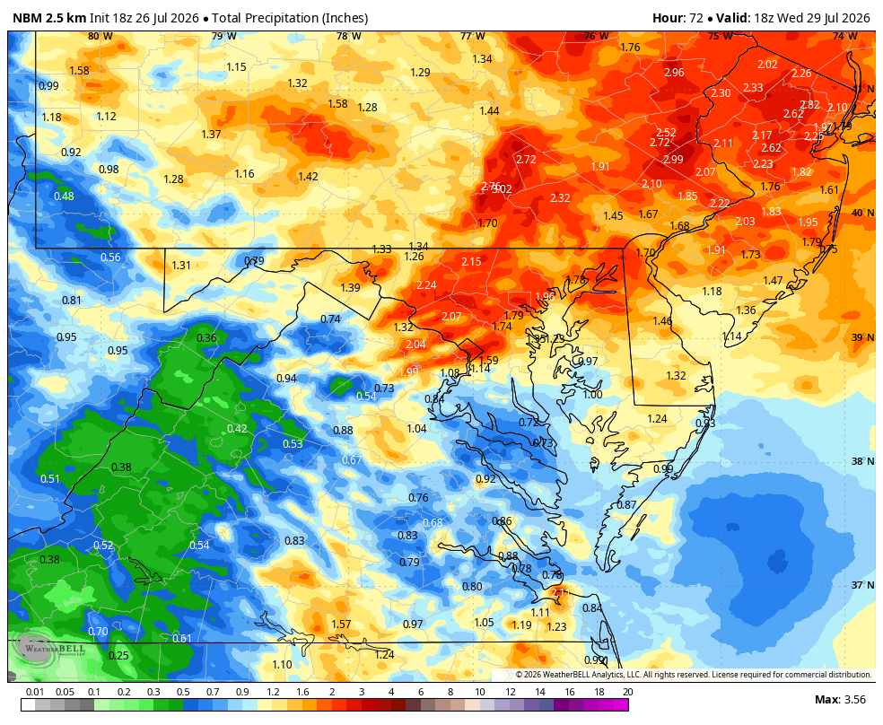
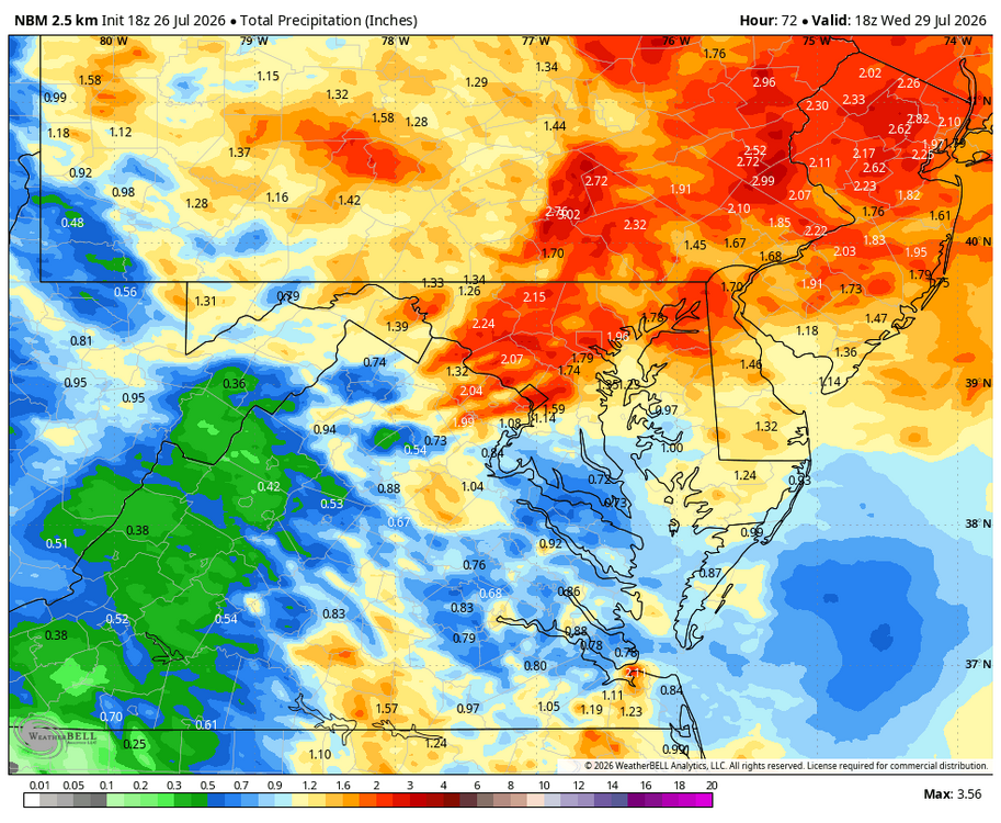
WB 18Z NBM thru 2pm Wed.
-

2026-2027 Super El Nino
Stormchaserchuck1 replied to Stormchaserchuck1's topic in Weather Forecasting and Discussion
Yeah, you know what's going on. I'd give the % chance of something like that happening like 5-10% right now. - Today
-
Bam going with historic warmth
-
 Stick with the 6z Euro in the paper bag.
 -

Mid-Long Range Discussion 2026
WinstonSalemArlington replied to BooneWX's topic in Southeastern States
July Nor’easter -

2026-2027 Super El Nino
GaWx replied to Stormchaserchuck1's topic in Weather Forecasting and Discussion
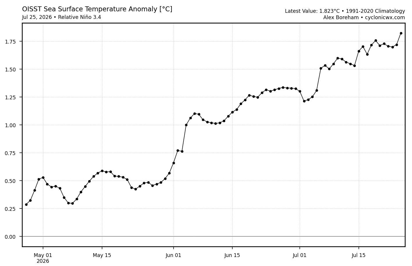
OISST relative in 3.4 rose a lot yesterday (~0.1C): What will tomorrow’s official weekly release show though? They’ve been lower than what these OISST graphs were suggesting. This graph suggests it will be +1.7C for the prior calendar week avg. However, they had it at only +1.4C last Monday despite this chart suggesting +1.6C. So, they’ve been low vs the graph. In reality, the graph suggests it warmed a little more than 0.1C since the prior week. So, we’ll see.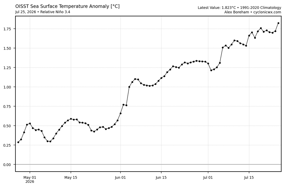
-
Latest update NWS Storm Prediction Center Norman OK SPC AC 261919 Day 3 Convective Outlook NWS Storm Prediction Center Norman OK 0219 PM CDT Sun Jul 26 2026 Valid 281200Z - 291200Z ...THERE IS A SLIGHT RISK OF SEVERE THUNDERSTORMS FROM THE SOUTHERN MID ATLANTIC INTO NORTH CAROLINA AND THE SOUTHERN APPALACHIANS... ...SUMMARY... Severe thunderstorms capable of damaging winds and isolated hail are possible from the southern Mid-Atlantic into the Carolinas and central and southern Appalachians Tuesday into Tuesday evening. Isolated severe wind gusts may occur in the central High Plains. ...Southern Mid Atlantic into North Carolina and southern Appalachians... An upper trough with a 40-50 kt midlevel speed max will push southeastward across the Appalachians and into parts of the Mid Atlantic and Carolinas during the day, supporting thunderstorms through much of the period. Storms are expected to be ongoing early Tuesday from PA and WV into eastern KY, near a cold front. This activity should persist as it moves into MD/VA/NC, where a surface trough will deepen. Daytime heating along with ample low-level moisture will support 1500-2000 J/kg MLCAPE, and winds will be veering with height, supporting a few supercells. Despite warm temperatures aloft, the 40-50 kt deep-layer shear may support hail in the strongest cells. In addition, southwesterly 850 mb winds up to 40 kt late in the day may yield an isolated tornado risk from southeast VA into NC. Moderately high PWAT along with steep low-level lapse rates during the peak heating hours will also support locally damaging wind gusts. ...Northern High Plains... Instability will increase over eastern WY, western SD/NE and northeast CO during the afternoon as a weak surface trough develops. Southeast surface winds will maintain 50s to lower 60s F dewpoints, with storms forming after 21Z near the higher terrain in WY/CO. South to southeast storm motions may bring multicellular storms across western NE and northeast CO during the evening with a few severe gusts possible. ..Jewell.. 07/26/2026 CLICK TO GET WUUS03 PTSDY3 PRODUCT NOTE: THE NEXT DAY 3 OUTLOOK IS SCHEDULED BY 0730Z CURRENT UTC TIME: 1936Z (3:36PM), RELOAD THIS PAGE TO UPDATE THE TIME
-

2026-2027 Super El Nino
EasternLI replied to Stormchaserchuck1's topic in Weather Forecasting and Discussion
Looking at the SST changes vs last year at this time would give you the impression this is an entire Pacific ocean event. Pretty wild. Which is interesting too because the entire ocean is really making all of the right moves towards a +IPO. Or interdecadal pacific oscillation. Which would include a longer term +PDO. The south pacific especially, but the NH is trying too apparently. Not much reason to think that wouldn't continue given everything either. Going to be a really impressive event to watch. Already is. Can we flip the longer term pacific too? It's been negative for quite some time. I envision that would take a monster event to set in motion. Or at least look like one. I could be wrong of course, but it so happens we have one... Fascinating. Impact of the Interdecadal Pacific Oscillation on Tropical Cyclone Activity in the North Atlantic and Eastern North Pacific https://www.nature.com/articles/srep12358 -

2026-2027 Super El Nino
40/70 Benchmark replied to Stormchaserchuck1's topic in Weather Forecasting and Discussion
Yea, basically 1982-1983. 2005 was a top 3 season in SNE....I don't expect that. -
Especially with no family history and being in such good overall health
-
2026-2027 Super El Nino
raindancewx replied to Stormchaserchuck1's topic in Weather Forecasting and Discussion
The Midwest Regional Climate Center snow maps for the years I picked. You can see generally the Northern Plains and Ozarks sort of get screwed for snow. Northwest does OK, especially if the PDO stays negative into Fall. Northeast does OK. Southeast & Southwest are generally furthest above means for snow. I can't get the maps to work for 2004-2005 and 1963-64. This is my attempt at drawing the consolidated snow maps. I put in a few example cities. So Richmond (~50%) is further above average than Philadelphia (~20%) and Philadelphia is further above average than Boston, which is a hair below (5-10%). Detroit and Chicago are around 20% below average. Topeka is right on the edge of the just below average/just above average zone (since it is low elevation, and blue western areas will be highly elevation dependent in a warm pattern for snow). Reno was something like 40% above average, Albuquerque around 20%. I'm using 1961-2020 as snow baseline. Billings is 3,000+ feet above sea level and around 15% below average. Those higher areas in the orange areas won't do too poorly, its the lower spots that get hosed. I may change my main analogs for temps, but I don't expect to change the snow maps. I'm pretty comfortable with this group for where moisture will be. -
Update on John Homenuk ("earthlight" from his days on these boards) Doing better but sounds like he had an awfully close call. Scary stuff. Best to him. https://people.com/healthy-36-year-old-reveals-warning-signs-before-suffering-widowmaker-heart-attack-exclusive-12018433?taid=6a5558621fb3140001d6dcb4&utm_campaign=peoplemagazine&utm_content=new&utm_medium=social&utm_source=twitter.com
-
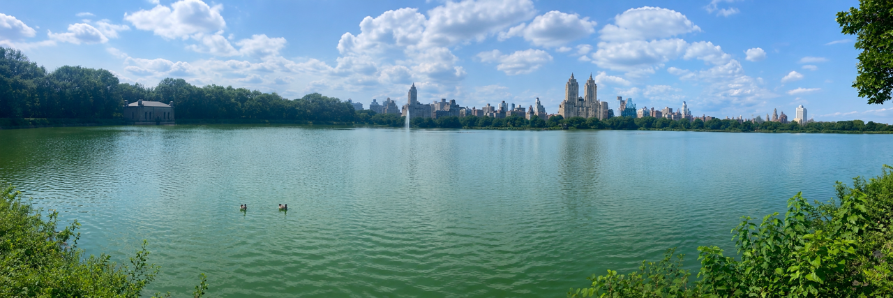
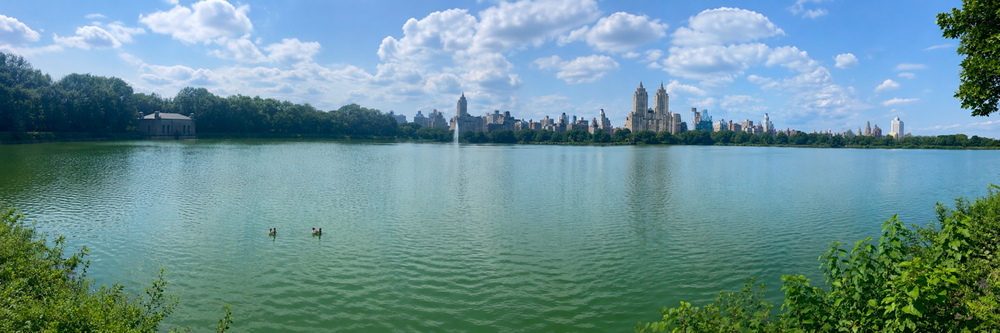
Gorgeous day at Central Park.
-
Exactly, that statement echoes what Mount Holly has in the latest AFD. The boundary may also stall in the Central and Northern regions leading to flash flooding.