All Activity
- Past hour
-

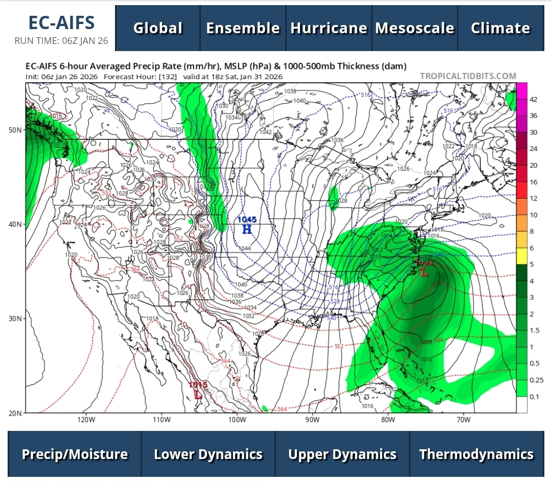
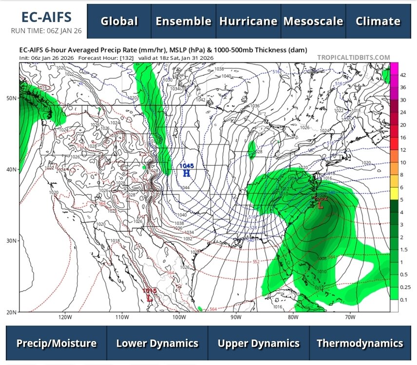
Possible coastal storm centered on Feb 1 2026.
dryslot replied to Typhoon Tip's topic in New England
Yes. -

Possible coastal storm centered on Feb 1 2026.
mahk_webstah replied to Typhoon Tip's topic in New England
In fact, you favored it over this storm. Let’s hope you were right! -

Possible coastal storm centered on Feb 1 2026.
Typhoon Tip replied to Typhoon Tip's topic in New England
Yes... one idiosyncrasy as we observe this thing in these early pages ... there is a preponderance of very deep members. That's been a thing with this for the past week's worth of modeling... the variance has been very all or nothing. I find that particular behavior interesting. Either the model in question has nothing ... or something sub-980 bombing. That's red flag as to potential - which we already know is there... but the member variance is typically narrower and closer to a mean that is more middling. Sub 980s are spread NW -
meanwhile in real time weather some snow showers/ swualls
-
Completely different topography/climo to negotiate here with hills, narrow streets and more ice. Massive equipment we can't use here makes the difference. I've seen people in Chicago abandoning cars on the freeway. You're only as good as equipment no matter what location. It's annoying when people in other climo say stuff because its powdery snow, wide flat open and monster trucks can make easy/clean passes. It's got nothing to do with the public's ability to drive.
-
Euro AI at 6z was almost perfect
-
Possible coastal storm centered on Feb 1 2026.
dryslot replied to Typhoon Tip's topic in New England
I made mention of this period as well as one i liked, Feb 1st-2nd time frame. -

January 2026 Medium/Long Range Discussion
NorthArlington101 replied to snowfan's topic in Mid Atlantic
LR thread is for discussing spring. Sorry -
You most definitely were gooning over it. The “Wiggum Storm” lives.
-
 Here's some longer timelapse videos from the start of the storm til this morning
 -
Yeah moderate to heavy snow threats the border counties.
-
Solid burst of snow in the area this morning for another 0.7”. 12.8” storm total. 30.8” for the season.
-
Blocking/EE rule.. what could go wrong?!
-
 I only know that the my local airport's official precip amount is 1.43".
 -

Central PA Winter 25/26 Discussion and Obs
Mount Joy Snowman replied to MAG5035's topic in Upstate New York/Pennsylvania
Can't leave out Blizz and Voyager..... ...Perry County... 1 NNE Liverpool 9.8 in 0720 PM 01/25 Trained Spotter Liverpool 9.5 in 0400 PM 01/25 Public 1 NNE Liverpool 9.3 in 0230 PM 01/25 Trained Spotter Marysville 8.8 in 0417 PM 01/25 Amateur Radio Millerstown 7.8 in 0200 PM 01/25 Trained Spotter 4 ESE New Bloomfield 5.0 in 0820 AM 01/25 Public ...Schuylkill County... 3 N Tuscarora 13.0 in 0630 PM 01/25 Public 1 NE Snyders 11.9 in 0925 PM 01/25 Public 4 WSW Pine Grove 11.0 in 0424 PM 01/25 Ringtown 10.5 in 0505 PM 01/25 Trained Spotter Auburn 10.0 in 0815 PM 01/25 Trained Spotter 4 WSW Summit Station 10.0 in 0408 PM 01/25 1 E Tower City 9.3 in 0445 PM 01/25 Trained Spotter Pine Grove 8.9 in 0840 PM 01/25 Other Federal 4 ENE Rough And Ready 5.8 in 1100 AM 01/25 Trained Spotter -
No way
-

Southern Crippler - Get well soon Jimbo Storm Obs
CentralNC replied to BooneWX's topic in Southeastern States
31 here. NW winds have picked up significantly in the last hour -
I went with 8.3. But I know it was more than that if I been religious about clearing my snow board.
-

January 2026 OBS and Discussion
SomeguyfromTakomaPark replied to TriPol's topic in New York City Metro
The 144 panel on the euro is absurd weather porn for nyc metro. 1 inch QPF in 6 hours with ripping wind. Madness if that verifies. -
ecords: Highs: EWR: 74 (1950) *monthly Jan high NYC: 72(1950) * tied monthly Jan high Jan 6 (07) LGA: 72 (1950) JFK: 69 (1950) Lows: EWR: 4 (1994) NYC: 2 (1871) LGA: 5 (1994) JFK: 9 (2007) Historical: 1698: The Charlestown to Boston, MA ferry was frozen for six weeks in the most severe winter of the 17th century. Heavy February snows followed. (Ref. Wilson Wx. History) 1700 - A powerful earthquake struck the Pacific Northwest along the Cascadia Subduction zone. The estimated moment magnitude of 8.7-9.2 caused about a 1,000-kilometer rupture from mid-Vancouver Island to northern California. The ocean floor heaved upward approximately 20 feet, and with 10-20 minutes, a giant wave, 30-40 feet high, reached the shore. The earthquake caused a tsunami, which struck the coast of Japan. 1772 - Possibly the greatest snowfall ever recorded in the Washington DC area started on this day. When the storm began, Thomas Jefferson was returning home from his honeymoon with his new bride, Martha Wayles Skelton. The newlyweds made it to within eight miles of Monticello before having to abandon their carriage in the deep snow. Both finished the ride on horseback in the blinding snow. The newlyweds arrived home late on the night of January 26th. In Jefferson's "Garden Book," he wrote, "the deepest snow we have ever seen. In Albermarle, it was about 3. F. deep." 1839: A storm brought rains, thaw, and floods to the area from eastern Pennsylvania to Maine and heavy snows from western Pennsylvania to northern Kentucky. (Ref. Wilson Wx. History) 1843: A destructive tornado hit a factory in Pottsville, PA, killing many people. (Ref. Wilson Wx. History) 1937: The wettest month ever in Cincinnati, Ohio, is January 1937, when 13.68 inches fell. Their average January amount is 3.00 inches of precipitation. The overabundance of precipitation over the Ohio River basin caused near-record to record flooding in Ohio, Indiana, Illinois, and Kentucky. On this day, the river gauge reached 80 feet in Cincinnati, the highest level in the city's history. The Ohio River reached 57 feet in Louisville, Kentucky, on the 27th, setting a new record by ten feet. Seventy percent of the city was underwater at that time. 1938: Perhaps the worst ice jam of record in the Niagara River gorge occurred at Niagara Falls, NY. Ice flows pouring over the falls, piled up to a height of more than 30 feet, 60 to 70 feet in spots. The tremendous pressure of the ice against the steel supports of the Falls View Bridge caused them to bend or break off. The abutments of the bridge were so weakened after more than 24 hours of battering that the great structure fell into the gorge at 4:13pm of the 27th. (Ref. Wilson Wx. Additional Information is Listed On This Link) 1940: Alabama and the Deep South were in the grips of a deep freeze. The official reading at the Birmingham City weather office in Alabama was 1°. The airport reading, the official location now, was -10°. Skaters were able to skate on the frozen surface of the Black Warrior River west of Birmingham, where ice was 6 inches thick near the banks. The cold followed on the heels of a 10-inch snowfall on the 23rd. The low temperature at Cheyenne, WY was -6°. This was the last of 10 consecutive days with a daily low temperature below zero which still stands as their longest streak ever recorded. (Ref. AccWeather Weather History) 1948: The minimum temperature for the date is +5°F. in Washington, DC. (Washington Weather Records - KDCA) 1950: Maximum was 79° the all time record high maximum for January in Washington, DC. (Washington Weather Records - KDCA) High pressure off the Carolina coast brought a second day of record high temperatures from Texas to New England. Many locations set record high temperatures for January including: Meridian, MS: 83°-Tied, Washington, DC: 79 °F, Baltimore, MD: 79°-Tied, Wilmington, DE: 75°, Philadelphia, PA: 74°, Newark, NJ: 74°, Harrisburg, PA: 73°-Tied, Allentown, PA: 72°, New York (Central Park), NY: 72°-Tied, New York (LaGuardia), NY: 72°-Tied, Boston, MA: 72° (the only time on record Boston has been above 70° in January), Milton, MA: 68° and Worcester, MA: 67°-Tied. (Ref. Wilson - Additional Temperatures Listed On This Link) 1961: A six inch snowfall took place today in Washington, DC which further enhances the snowy winter conditions of 1961. (p. 73 Washington Weather Book 2002 by Ambrose, Henry, Weiss) 1966: The second storm in a series occurred today and produced heavy snows south and east of Washington. Richmond received 15 inches of snow and much of the southern and eastern Maryland received 10 to 17 inches. National Airport reported 7.5 inches andDulles reported 6 inches of snow. (p. 76 Washington Weather Book 2002 by Ambrose, Henry, Weiss) (Ref. Wilson Wx. History) 1967: On the 26th and 27th Chicago Illinois was blanketed by 23 inches of snow, it's single heaviest snow of record. Its three major airports were closed; an estimated 20,000 cars and 500 buses were stranded on city streets. Some of the plowed snow was sent to Florida in railroad cars. (Weather Guide Calendar with Phenomenal Weather Events 2007 Accord Publishing, USA) Twenty-nine hours after it started, the unprepared city of Chicago was buried under twenty-three inches of snow. Winds gusted to fifty mph, creating whiteout conditions and drifts up to twelve feet high. Thousands of cars and buses were abandoned by their drivers all over the city, making the job of plowing the streets nearly impossible. It still stands as Chicago's greatest snowstorm.(Ref. AccWeather Weather History) 1977: Four days of very strong winds occurred from the 26th through the 29th across the northern Plains with a strong low pressure area over western Ontario Canada. Strong northwest winds of 30 to 45 mph with gusts over 60 mph caused widespread blowing and drifting snow with most roads closed with many traffic accidents in parts of South Dakota. The winds combined with subzero temperatures to create wind chills of -60° to -80°. Many schools were closed for several days. (Ref. Wilson Wx. History) (Ref. AccWeather Weather History) 1978 - A paralyzing blizzard struck the Midwest. One to three feet of snow fell in Michigan, and 20 to 40 inches was reported across Indiana. Winds reached 70 mph in Michigan, and gusted above 100 mph in Ohio. The high winds produced snow drifts twenty feet high in Michigan and Indiana stranding thousands on the interstate highways. Temperatures in Ohio dropped from the 40s to near zero during the storm. (David Ludlum) 1982: Residents across the Northern Plains were still cleaning up from the third consecutive weekend of severe winter weather. On January 22nd through the 24th, a record breaking snowstorm struck much of South Dakota, Minnesota, and Iowa. Amounts across South Dakota ranged from 6 to 20 inches. The heaviest snow, at Elk Point, was accompanied by a rare January thunderstorm. Sub-zero temperatures across the area combined with 30 to 50 mph winds to produce wind chill values of -50° to -80°. Travel became impossible in the height of the storm as over 90% of roads in central and eastern South Dakota were blocked. Snow plows couldn't make any headway until the storm had passed. Drifts up to 15 to 20 feet buried the area. Sioux City, IA piled up 18 inches of snow as all roads in northwest Iowa were closed on the 22nd. Conditions were no better in Minnesota. Minneapolis set, what up to that point was, a single storm snowfall record with 18.5 inches. Incredibly, the record that this storm broke had just been set two days earlier when 17.4 inches buried the Twin Cities. That's nearly 36 inches of new snow in just over three days. (Ref. Wilson Wx. History) 1983 - The California coast was battered by a storm which produced record high tides, thirty-two foot waves, and mudslides, causing millions of dollars damage. The storm then moved east and dumped four feet of snow on Lake Tahoe. (22nd-29th) (The Weather Channel) 1987 - A winter storm spread heavy snow across the Middle and Northern Atlantic Coast States, with 18 inches reported at Vineland NJ, and wind gusts to 65 mph at Chatham MA. Snow cover in Virginia ranged up to thirty inches following this second major storm in just one week. (National Weather Summary) (Storm Data) 1988 - A snowstorm in the northeastern U.S. produced 19 inches at Austerlitz NY and Stillwater NY. A storm in the Great Lakes Region left 16.5 inches at Marquette MI, for a total of 43 inches in six days. (National Weather Summary) (Storm Data) 1989 - Snow and high winds created blizzard-like conditions in northwestern Vermont. Winds at Saint Albins gusted to 88 mph. In Alaska, the town of Cold Foot (located north of Fairbanks) reported a morning low of 75 degrees below zero. (National Weather Summary) (Storm Data) 1990 - A winter storm spread high winds from the northwestern U.S. to Wyoming and Colorado, with heavy snow in some of the high elevations. Stevens Pass WA received 17 inches of snow, half of which fell in four hours. In extreme northwest Wyoming, Togwotee Mountain Lodge received 24 inches of snow. Winds in Colorado gusted to 90 mph at Rollinsville. (National Weather Summary) (Storm Data) 1996: A strong winter storm moved northeast from Iowa and blanketed much of the southwest and central Wisconsin with 10 to 18 inches of snow. The heaviest snow occurred along a 100 mile axis centered from La Crosse northeast toward Fort McCoy and further into northeast Wisconsin. An isolated report of 18 inches was reported 6 miles east of La Crosse and the La Crosse Regional Airport received 12 inches. Blizzard conditions existed during the height of the storm that left drifts 4 to 8 feet high. Travel was nearly impossible. The snow lingered into the early morning hours of the 27th. Green Bay, WI reported 15.3 inches. The 13.7 inches at Des Moines, IA was the city's biggest snowstorm in nearly 23 years. 13 inches of snow fell in 24 hours at La Crosse, WI, the city's greatest 24 hour snowfall total ever in January. Madison, WI record 8 inches of snow in just two hours. Thunderstorms spawned by the same storm system deluged Birmingham, AL with 4.71 inches of rain, their greatest daily January rainfall on record. (Ref. Wilson Wx. History) 2003: The temperature finally went above freezing at New York City, NY for the first time in 12 days as the temperature rose to a high of 34° in Central Park. The streak of sub-freezing temperatures tied for 3rd longest in New York City history. Despite the very cold temperatures during the streak, no daily records were broken. (Ref. Wilson Wx. History) 2011: New York continues to have a brutal winter. The Big Apple was walloped with 19 inches. Philly had 17 inches. Parts of Northern Connecticut had 16-19 inches. Here’s how severe this winter has been: Before yesterday’s storm, Hartford had already recorded its snowiest January on record and those records go back over 100 years. Hartford's old record was 43 inches for January. (Ref. More on the Record Breaking Snows In New England and Hartford CT)
-

Southern Crippler - Get well soon Jimbo Storm Obs
WarmNoseHater replied to BooneWX's topic in Southeastern States
already up to 36 in Charlotte with the sun coming out - if it really gets to 41 today we may melt the roads clean! -
Central PA Winter 25/26 Discussion and Obs
Mount Joy Snowman replied to MAG5035's topic in Upstate New York/Pennsylvania
Whoa that's a big number! Here are some local totals from CTP..... ...Adams County... 1 W Cashtown 7.4 in 0605 PM 01/25 CO-OP Observer Littlestown 7.0 in 0100 PM 01/25 1 NNW Mcsherrystown 6.2 in 1101 AM 01/25 Trained Spotter Abbottstown 5.8 in 0400 PM 01/25 Trained Spotter 3 ESE Carroll Valley 4.6 in 0823 AM 01/25 ...Cumberland County... 1 SSE Hogestown 8.5 in 0530 PM 01/25 Public Mechanicsburg 8.1 in 0237 PM 01/25 Public 2 ENE Wertzville 8.0 in 1045 AM 01/25 Other Federal 1 ENE Mechanicsburg 7.5 in 0620 PM 01/25 Public 1 W Camp Hill 7.3 in 1200 PM 01/25 3 ESE Bloserville 7.0 in 0844 PM 01/25 Trained Spotter 1 S Carlisle 7.0 in 0200 PM 01/25 Public 2 SW Bloserville 6.5 in 1200 PM 01/25 Trained Spotter Shippensburg 6.5 in 0600 PM 01/25 Amateur Radio Enola 6.0 in 0834 AM 01/25 Public Shippensburg 6.0 in 0206 PM 01/25 Trained Spotter Carlisle 7.2 SSW 4.0 in 0830 AM 01/25 COCORAHS ...Dauphin County... Millersburg 11.7 in 0600 PM 01/25 Public 1 WSW Middletown 11.0 in 0500 PM 01/25 Official NWS Obs 1 SW Linglestown 9.5 in 0803 PM 01/25 2 NNE Highspire 9.0 in 0530 PM 01/25 Millersburg 9.0 in 0421 PM 01/25 Emergency Mngr 2 NNW Hershey 8.5 in 0530 PM 01/25 Broadcast Media 4 NE Halifax 8.1 in 1218 PM 01/25 Trained Spotter Hershey 7.5 in 0245 PM 01/25 Broadcast Media 2 NW Hershey 7.5 in 0950 PM 01/25 Trained Spotter 1 S Rockville 7.5 in 0105 PM 01/25 Broadcast Media 3 SE Middletown 7.0 in 1140 AM 01/25 Trained Spotter 1 SE Progress 7.0 in 1254 PM 01/25 Progress 4.2 in 1006 AM 01/25 Emergency Mngr ...Lancaster County... Denver 13.0 in 0730 PM 01/25 Trained Spotter 3 NNE Denver 12.5 in 0800 PM 01/25 Public 2 ENE Mountville 12.0 in 0650 PM 01/25 Public 1 E East Petersburg 9.5 in 0307 PM 01/25 4 W Leola 9.1 in 0454 PM 01/25 2 S East Petersburg 9.0 in 1254 PM 01/25 Trained Spotter 1 NW Manheim 9.0 in 0235 PM 01/25 Akron 8.8 in 0320 PM 01/25 Public 1 ENE Marietta 8.8 in 0800 PM 01/25 1 E Lancaster 8.5 in 0941 PM 01/25 Public 3 NE Terre Hill 8.4 in 0830 PM 01/25 Public 3 NNE Terre Hill 8.2 in 1232 PM 01/25 2 NW Leola 8.1 in 0600 PM 01/25 Public 3 N Denver 8.0 in 0130 PM 01/25 Broadcast Media Ephrata 8.0 in 1225 PM 01/25 Trained Spotter 2 N Millersville 8.0 in 0740 PM 01/25 Trained Spotter Millersville 8.0 in 0935 PM 01/25 Cocorahs 2 W Lancaster 7.8 in 1155 AM 01/25 Broadcast Media 3 N Lancaster 7.0 in 1145 AM 01/25 Manheim 6.0 in 1120 AM 01/25 Public Rothsville 5.0 in 0910 AM 01/25 Public ...Lebanon County... 1 WSW Lebanon 12.0 in 0615 PM 01/25 Trained Spotter 1 NW Palmyra 9.3 in 1230 PM 01/25 Campbelltown 7.5 in 1100 AM 01/25 Public Palmyra 7.2 in 0500 PM 01/25 Public 2 SE Penn National Race 5.8 in 1115 AM 01/25 Emergency Mngr Palmyra 5.5 in 0936 AM 01/25 Lebanon 4.3 in 0830 AM 01/25 Public ...York County... Red Lion 12.0 in 0604 PM 01/25 2 NNW Spry 8.0 in 1035 AM 01/25 Broadcast Media 3 NNE Wellsville 8.0 in 0257 PM 01/25 Wrightsville 8.0 in 0130 PM 01/25 Public 2 NW Codorus 7.5 in 0348 PM 01/25 Trained Spotter York 7.5 in 0710 PM 01/25 Trained Spotter 3 ESE Felton 7.3 in 0920 PM 01/25 Trained Spotter Loganville 7.0 in 0240 PM 01/25 Trained Spotter 2 S York 7.0 in 0710 PM 01/25 Public 2 NW Stonybrook 6.8 in 0700 PM 01/25 Emergency Mngr Glen Rock 6.5 in 1245 PM 01/25 Public 3 NE Dover 6.2 in 1115 AM 01/25 Trained Spotter 2 NNW Valley Green 6.0 in 1000 AM 01/25 1 ENE New Freedom 5.0 in 1100 AM 01/25 Trained Spotter New Salem 5.0 in 0100 PM 01/25 Trained Spotter -
Seems like a general 14-17" snowfall throughout the entire region. Haven't seen that much uniformity in snow totals in quite some time
-
How much you end up with most recent storm?


.thumb.jpg.9707d4addca3d84715ae3d888c5c10d6.jpg)