All Activity
- Past hour
-
I think I'd call it 16.5" here in Thomaston. Measured about 14.5" of depth last night, then another 3/4 inch today on the car after I cleared it off last night so accounting for some loss due to compaction I think that makes sense.
-
Perhaps Robert? @wxsouth
-
does B'more City run school buses?
-

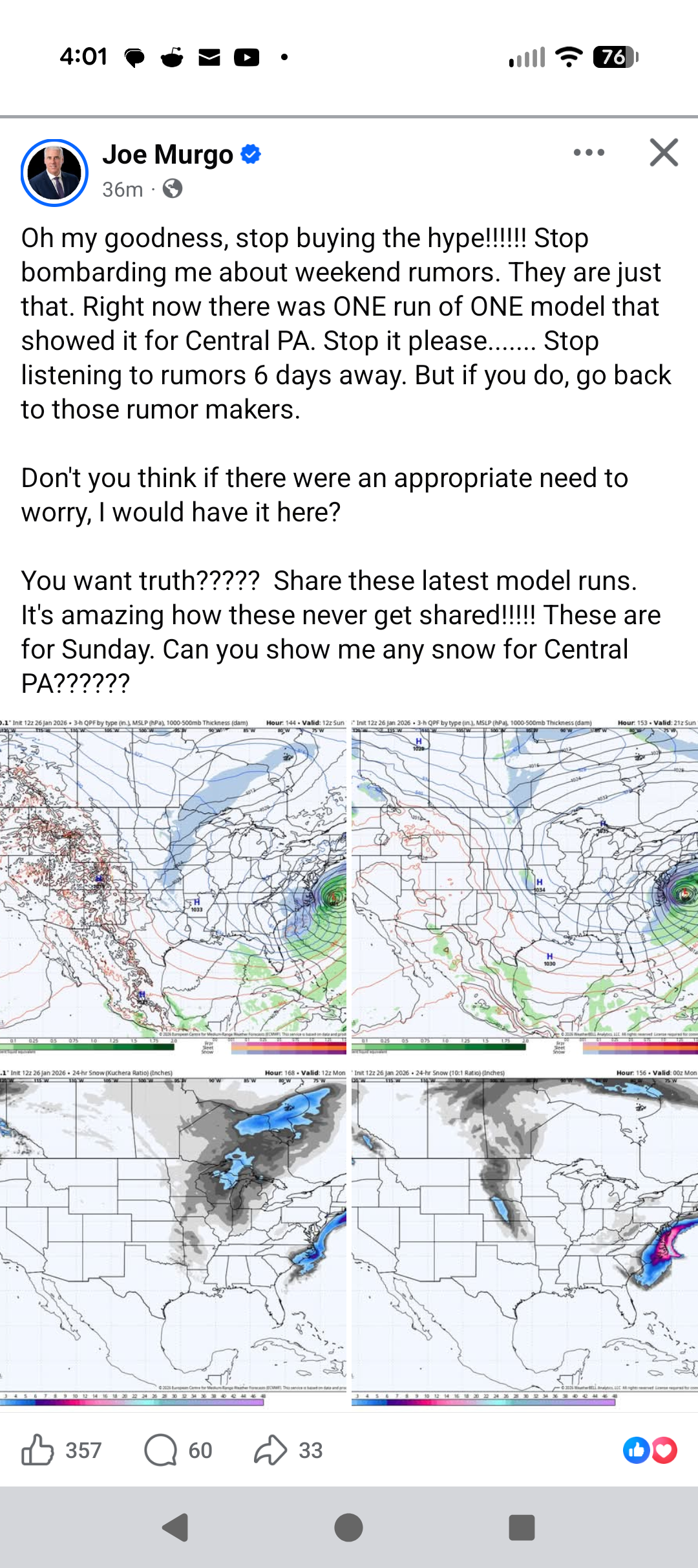
Central PA Winter 25/26 Discussion and Obs
canderson replied to MAG5035's topic in Upstate New York/Pennsylvania
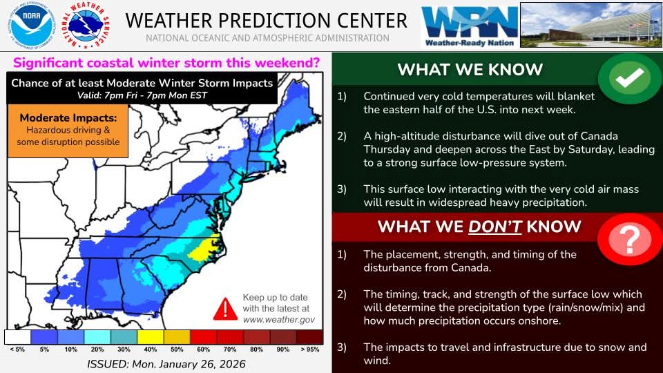
He should talk to CTP who has this in their latest disco. KEY MESSAGE 2: Potential East Coastal Storm Threat this weekend There is a growing guidance signal and slightly westward trend/earlier phasing of short waves and amplification of a large scale trough for the development of a potentially impactful weekend coastal storm along the Eastern Seaboard. We will continue to closely monitor this given risk of snow and wind impacts. The track and intensity of the surface moving north-northeast just off the Carolina and Delmarva coasts would lead to a higher east/northeast wind threat during the storm, and stronger NW winds in its wake. -

January 25-26th, 2026 Final Storm Totals
The 4 Seasons replied to The 4 Seasons's topic in New England
14.1" matches up well. you satisified with this one now? One of the best storms we've ever had imo. Full daytime, 2"/hr rates, 6-7F for most of it, didn't bust. Definitely my favorites since Feb 2021. -
 No. Kellys bday at sunday river Sent from my SM-S921U using Tapatalk
 -
You would be correct
-
So you're telling me there's a chance lol
-
 nice burst of OE now
 -
We have a ways to go with this one. Going to be a fun week
-

Central PA Winter 25/26 Discussion and Obs
WmsptWx replied to MAG5035's topic in Upstate New York/Pennsylvania
I can't imagine what current and former TV mets are dealing with right now. But I can't imagine this is the only crash out ongoing.
-
Still can go OTS or just close enough IMO
-
IMO, this remains a closer call than with the most recent storm where I believed it would not be suppressed. I still think the most likely scenarios are either up the coast (track and distance from the coast to be determined) or out-to-sea (lesser probability). The scenario of an inland cutter is probably the lowest probability right now. This is based on the forecast pattern. Synoptic details can't be resolved accurately at this timeframe. We'll see where things are by Wednesday or Thursday.
-
 17F Heavy snow. We missed out on the heavy action yesterday and last night but are making up for it this afternoon. Excellent snow growth. Visibility is still more than 1/4 mile but the large dendrites are accumulating very fast.
 -
Yeah 30” for me during that one on LI
-
They will I work in the coms department that did this video
-
 Second part is/has been a dud here
 -
.thumb.png.4150b06c63a21f61052e47a612bf1818.png) I was skeptical, but nice to tack on a bonus inch this afternoon maybe even a little bit more when it’s done.
I was skeptical, but nice to tack on a bonus inch this afternoon maybe even a little bit more when it’s done. -
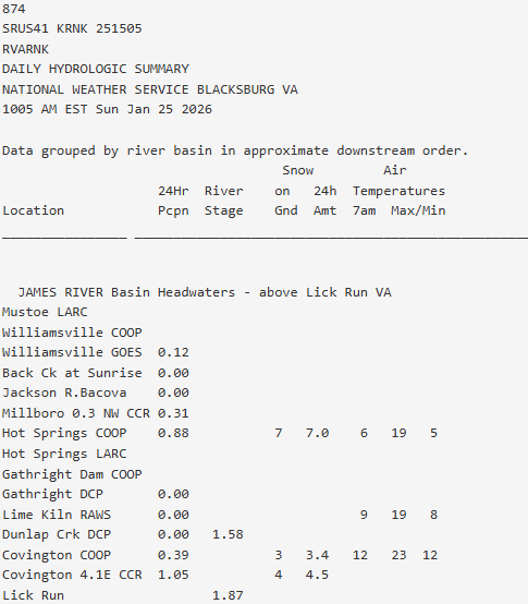
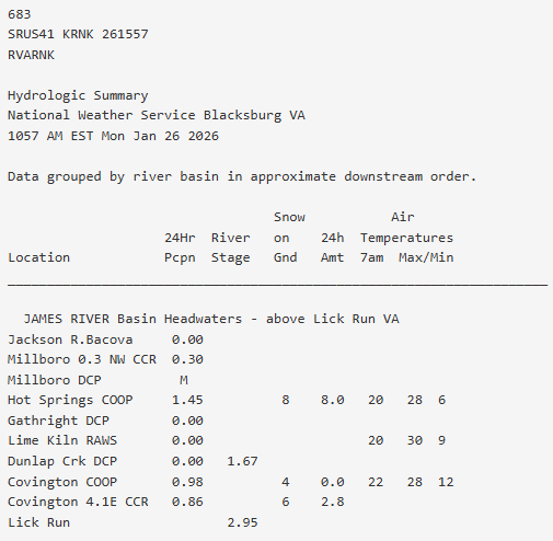
I JUST got off the phone with NWS Blacksbug. They were trying to confirm what happened in this area this weekend. I gave them my totals, what was on the ground now and what types of precip I had. And WHY would they call you ask? Well, Covington CO-OP (who is notorious for reporting either low or not at all) reported 3.4 inches yesterday 0.0 today and 4 OTG this morning. So they INCREASED OTG but reported no new snow. Then Hot Springs CO-OP (which usually does a great job) reported 7.0 yesterday with 7.0 OTG, then 8.0 this morning with 8.0 OTG (I'm guessing they oopsied and put OTG for new snow too). BTW- I'm the 4.1 E Covington
-
Looks like MCPS can’t even get to the busses at Shady Grove. They’ll be digging them out for a while. Hoping mcps closes all week, I think they will.
-
 Yup. More pillows IMG_7867.mov
 -

Pittsburgh/Western PA WINTER ‘25/‘26
Burghblizz replied to Burghblizz's topic in Upstate New York/Pennsylvania
Models are flip flopping, but even the western solutions don’t really get much to western Maryland. So wouldn’t see anything meaningful yet on timing or of it’s even a factor. Edit: Actually Euro last night did get very heavy snow there, with it wrapping up by midday Sunday. But I think it’s still too early to really know. -
14.5” Hamden.
-
Temp maxed at 30 which helped some melting. Headed back down now. 27 and it’s gotten hella windy
-
I think the biggest uncertainty we're going to have with this system is the energy coming from northern Canada. That has a lot to interact with over the next few days as it does a 360 degree loop over James Bay.


.thumb.jpeg.f5c6ba9d911ec96b3b124f8606aee58e.jpeg)