All Activity
- Past hour
-
July 21 2002: Dew points reach 84 degrees at Madison, Morris, and Olivia. This ties the all time highest dew point reading in Minnesota, as recorded by the State Climatology Office. 1934: Extreme heat hits western Minnesota, and the temperature topped out at 113 at Milan. For Tuesday, July 21, 2026 1911 - The temperature at Painter, WY, dipped to 10 degrees to equal the record low for July for the continental U.S. (The Weather Channel) 1934 - The temperature reached 109 degrees at Cincinnati, OH, to cap their hottest summer of record. The state record for Ohio was established that day with a reading of 113 degrees near the town of Gallipolis. (David Ludlum) 1975 - Six inches of rain fell across Mercer County, NJ, in just ten hours causing the worst flooding in twenty years. Assunpink Creek crested eleven feet above flood stage at Hamilton and Trenton, the highest level of record. Traffic was brought to a standstill, and railway service between New York City and Washington D.C. was cut off for two days. Flooding left 1000 persons homeless, and caused an estimated 25 million dollars damage. (David Ludlum) 1987 - Thunderstorms produced severe weather from Utah to North Dakota, spawning a dozen tornadoes in North Dakota. Thunderstorms in North Dakota also produced baseball size hail at Clifford which caused four million dollars damage, and high winds which toppled a couple of eighty foot towers cutting off power to the town of Blanchard. (The National Weather Summary) (Storm Data) 1988 - While cool air invaded the central U.S., unseasonably hot weather continued over the western states. The temperature at Spring Valley, NV, soared from a morning low of 35 degrees to an afternoon high of 95 degrees. Fallon, NV, reported an all-time record high of 108 degrees, and Death Valley, CA, reported their sixth straight day of 120 degree heat. (The Weather Channel) (The National Weather Summary) 1989 - Afternoon thunderstorms over Florida produced wind gusts to 92 mph at Jacksonville, damaging thirteen light planes at Herlong Field. Five cities in Texas reported record low temperatures for the date. Corpus Christi, TX, equalled their record low for the date with a reading of 71 degrees, and then tied their record high for the date that afternoon with a reading of 97 degrees. (The National Weather Summary) (Storm Data) Observances: 21 Tue National Junk Food Day 21 Tue Invite an Alien to Live with You Day 21 Tue Legal Drinking Age Day 21 Tue National Craft for your Local Shelters Day 21 Tue National Be Someone Day 21 Tue No Pet Store Puppies Day 21 Tue Take a Monkey to Lunch Day
-
 warning went out for that after my post, but that is for the cell south of the one I was referring too
 -
 Why isn't it dying...warm front storm?
 -

2026-2027 Super El Nino
Typhoon Tip replied to Stormchaserchuck1's topic in Weather Forecasting and Discussion
I'd be careful with the bold ... The straight up linear correlation, sure - that's ...sort of similar to the tripole SST state, which is highly correlated to -NAOs..etc..etc..but, the causality of why that colder region is notable there is circumstantially - quite possibly - evolved for different reason.. Mimicry, in other words. There's is ongoing research about the "Atlantic cold blob" that is being geophysically connected to a longer term modality with the AMOC ... Of course, CC and attribution science is all over that. Some bigger media, definitely social media doomers, are pumping out warnings how that's portends the end of the G-string circulation eddy et al the new paradigm equals unfamiliar 'Day After Tomorrow'-isms ... yadda yadda. Who knows, but the point is, if there are kernels of truth to that whole science and/or science-narrative, on-going, than it's not really being caused for the same reasons the tripole correlation exists. -
 There’s a warning for that storm
 -
Then the 13z HRRR comes in and is back to total garbage for everyone.
-

2026 Mid-Atlantic Severe Storm General Discussion
jewell2188 replied to Kmlwx's topic in Mid Atlantic
On our way to a bust! -
Just measured here and have exactly 1.25" in both the electronic tipper and the plastic one. The sun had come out but now clouds and darker skies have returned. It looks like more spots are starting to develop to the SW again and we'll see if they bring anything. I had a quivering, panting dog glued to me earlier so she is unhappy with this morning's weather. We'ved tried music, calming chews, treats, and playing with her. Nothing seems to help. As I finish typing, rain has started again here.
-
Picked up 0.04"- 0.21" from a quick shwr last night around TH. Cool morning feels good. House temp down to 71 (had been staying in the upper 70's since the heatwave with 80's in the aftrn) with windows open last night, and a cool breeze from the NW. Looking at highs in the mid-upper 70's today.
-
 I don’t know what celestial sex toy has been interfering with our thunderstorms but I’m not happy
 -
 It’s nice now, sunset at 11pm last night and sunrise 4am. Winter must be a toaster bath of darkness though. Everything goes straight up from the ocean… and it’s wild the hanging snowfields above treeline (low treeline, like 2,000ft) up at 4-6,000ft still hang on through summer in areas. One local was joking that the natural snow up high that isn’t glaciated usually melts by mid-August and then two weeks later it starts snowing up there again to build the new snowpack.
 -

2026 Mid-Atlantic Severe Storm General Discussion
StormyClearweather replied to Kmlwx's topic in Mid Atlantic
KEY MESSAGE 1...STRONG TO SEVERE THUNDERSTORMS ARE STILL POSSIBLE TODAY, WITH SOME THUNDERSTORM RISK LINGERING INTO WEDNESDAY. TODAY'S FORECAST HAS BECOME VERY COMPLICATED/UNCERTAIN DUE TO EXTENSIVE HIGH DENSE OVERCAST MOVING IN FROM THE NORTHWEST ASSOCIATED WITH THUNDERSTORM COMPLEX OVER EASTERN OH AND NORTHWEST PA. THIS WILL LIKELY CUT DOWN ON HEATING, ESPECIALLY ACROSS NORTHERN AREAS WITH TEMPERATURES STRUGGLING TO REACH 90F BASED ON CURRENT TRENDS. CENTRAL AND SOUTHERN VA SEEMS LIKE IT WILL SEE THE MOST HEATING AND THE HIGHEST PROBABILITIES OF SEVERE WEATHER. MANY CAMS SHOW A MINIMA IN QPF BETWEEN THE ALLEGHENIES AND THE BLUE RIDGE MOUNTAINS. ALSO, HRRR FORECASTS ARE LIKELY OVERDONE AS IT HAS TEMPERATURES REACHING INTO THE MID AND UPPER 90S, WHICH AIN'T HAPPENING BASED ON 24-HR MODEL AND CURRENT TRENDS. WHILE THE POTENTIAL STILL EXISTS FOR SEVERE WX, THERE ARE STILL MANY UNKNOWNS AT THIS TIME. -
Same here. Absolute deluge. A few CTG streaks followed by very loud thunder. Wind gusts modest at perhaps 30 mph briefly. Will go get a measurement shortly. Easily over 1".
-
Many thanks!
-
Absolutely nasty looking cell on radar. 65+ dbz.
-
Definitely at least 50kt based on recon so far. It's interesting how despite getting blasted by shear we're still seeing gradual organization and intensification. This would have probably been making a run toward "minimal" hurricane status if there were even slightly lower shear. Still going to be hard to get there with shear expected to increase further. Hard to intensify substantially with the vortex so misaligned though I guess Barry (which I chased years ago lol) did. You can see despite the organizational trend that it cannot wrap convection around the center. That's a pretty critical piece for significant intensification.
-
SPC has slight and marginal out for TN today all hazards 2% tornado with 5% tornado in ky 5% hail and 5-15-30% wind non hatched also not all of TN is in each hazard either except for wind https://www.spc.noaa.gov/products/outlook/day1otlk.html .
-
Sure thing. 12z HRRR: Around 3/4pm - Puts a couple of decent pre-frontal discrete cells from MDT south to DC, looks like one cell gets beefy east of Baltimore along maybe a bay breeze boundary? Around 4 - 6pm - Develops a respectable line of storms along I-81 and runs it from MDT down to RIC around sunset. That would be a solid slight risk day in these parts. If folks hold their expectations to that, then no one would be dissappointed.
-

2026 Mid-Atlantic Severe Storm General Discussion
SnowenOutThere replied to Kmlwx's topic in Mid Atlantic
I haven’t looked a ton at the setup and won’t be able till past midday. It seems similar up Monday but with less CAPE traded for better shear both upper and lower levels. Considering we got some supercells then, I see no reason why we couldn’t get them today. -
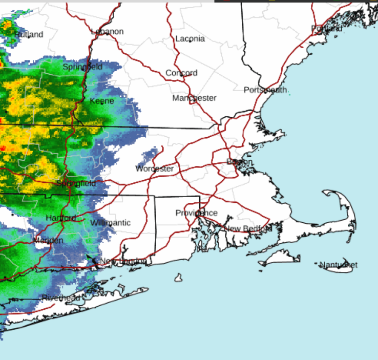
nah... sat and rad trends expose a massive cosmic dildo pounding the bum of convective hopefuls
-
maybe because its a bit elevated but surprised no warning or at least a SPS on that cell heading towards Fairfield County/Danbury...decent wind signature on velocity
-
Mind posting? On mobile so can’t look easily
-

Pittsburgh PA Summer 2026 Thread
PghPirates27 replied to TheClimateChanger's topic in Upstate New York/Pennsylvania
Looks like most of the heavy rain is going to be south of I-70 -
Looking upstream, if we can get these debris clouds over West Virginia to fade out, we should be okay for at least some thunder. The cluster of storms coming through Columbus, OH right now has an uptick in CG and seems to be drifting southeast. Wonder if that's our show for later?
-
Could be a nice line that organizes early tomorrow afternoon for E CT and points east