All Activity
- Past hour
-
Low of 70F at INL this morning, which will easily surpass the monthly record high minimum of 66F set on 5/21/1992 & 5/31/1988. In fact, it's only one degree shy of the June monthly high minimum of 71F set on 6/25/2001. With that said, it is possible that it may fall below 70F by 1 am CDT / midnight CST, but it should stay above 66F. The forecast low tonight is 64F at INL.
-

Spring 2025 Medium/Long Range Discussion
Jackstraw replied to Chicago Storm's topic in Lakes/Ohio Valley
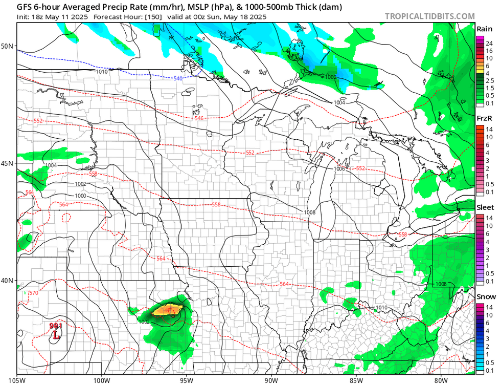
06Z GFS throwing out wacked precip totals for the next 10 days with upwards of 7- 8 inches near the Chicago area, 3-4 around here. It needs to back off the shrooms -

Central PA Spring 2025
Mount Joy Snowman replied to canderson's topic in Upstate New York/Pennsylvania
Low of 52. One more nice day before we get locked in the gloom. -
Todd Nelson is a hell of a coach. He made some changes for Friday night game 4 in Lehigh and made a huge difference in Friday/Sunday Play. Good coaches know when and how to shake things up and he is a magician. Take note of how scrappy lehigh was/is. They wanted to fight, bad. Bears didn't fall for it.
-
Summer to Spring this week. Potential snow along the border this weekend.
-
heaviest rains over the southeast next 5 days through Friday then front on Saturday could bring storms to the area.
-
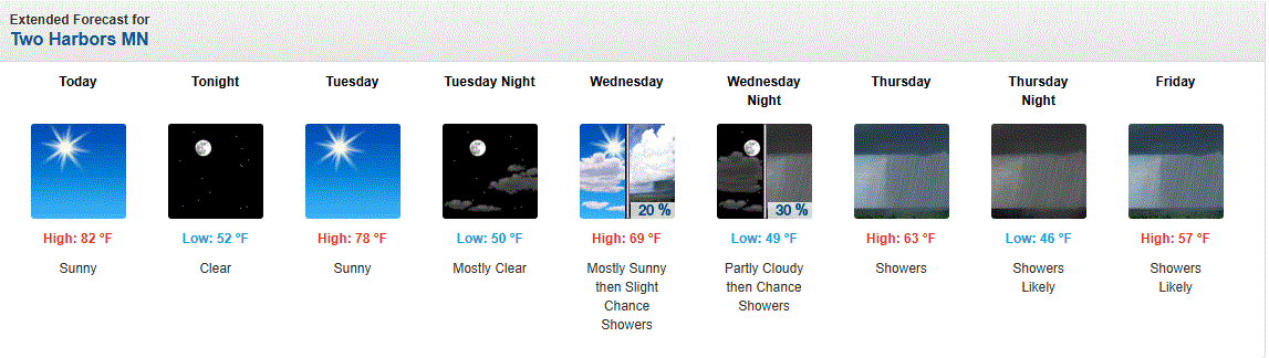
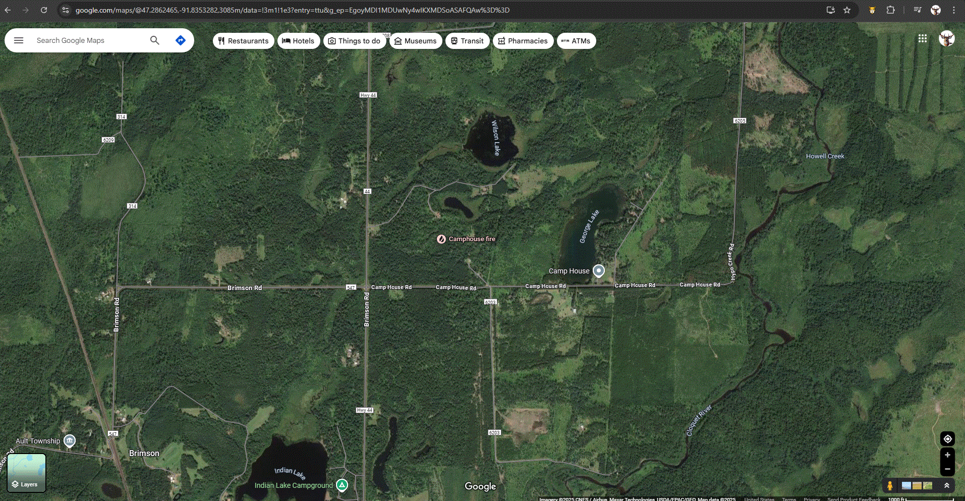
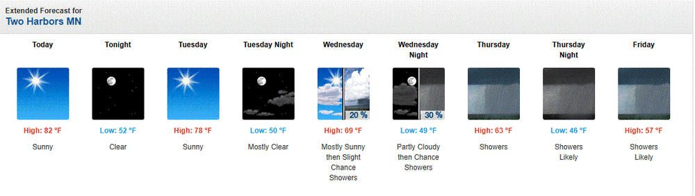
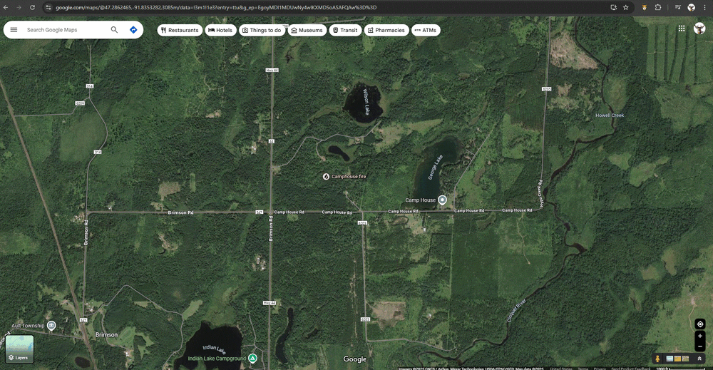
"Camphouse Fire" it's called, as it's just on the N side of Camphouse Rd. It was 200 acres last night, maybe a bit more this morning. Very, very dry conditions. Rel Hum was like desert air yesterday around 10% or so. Temps skyrocketed because of that on stiff SW winds. Here in town, temps steadily climbed into the mid 70's until around 10pm or so, as the S winds started shifting SW, lessening the Lake's influence. Another hot one today.
-
Records: Highs: EWR: 92 (1959) NYC: 93 (1881) LGA: 88 (1991) JFK: 89 (1991) Lows: EWR: 40 (1938) NYC: 40 (1907) LGA: 43 (1940) JFK: 43 (2020) Historical: 1760: Ben Franklin was the first person to identify nor'easters. In a letter on this date, Franklin described an experience that happened to him in November 1743 when storm clouds in Philadelphia blocked his view of an eclipse. Franklin assumed that the storm had blown in from the northeast because the surface winds at his location were from that direction. He was puzzled to find out later that his brother had viewed the eclipse with no problems and that the storm had arrived in Boston four hours later. The information caused Franklin to correctly surmise that the storm had moved from southwest to northeast. 1834: Unusual snows occurred across the Northeast. 6 inches fell at Erie, PA and 12 inches at Rutland, VT from this date through the 15th. 1876: The first American newspaper weather map was published in the New York Herald. Weather maps would first appear on a regular basis beginning on May 9, 1879 in the New York Daily Graphic. 1934 - A dust storm darkened skies from Oklahoma to the Atlantic coast. (David Ludlum) 1971 - Duststorms suddenly reduced visibilities to near zero on Interstate Highway 10 near Casa Grande AZ. Chain reaction accidents involving cars and trucks resulted, killing seven persons. (The Weather Channel) 1972 - In Texas, A cloudburst dumped sixteen inches of rain north of New Braunfels sending a thirty foot wall of water down Blueders Creek into the Comal and Guadalupe Rivers washing away people, houses and automobiles. The flood claimed 18 lives and caused more than twenty million dollars damage. (The Weather Channel) 1982 - A late season snowstorm struck the Front Range of the Colorado Rockies. The storm produced 46 inches of snow at Coal Creek Canyon, located near Boulder. (David Ludlum) 1987 - A heat wave persisted in central California. Afternoon highs of 100 degrees at Fresno CA and 102 degrees at Sacramento CA were records for the date. (The National Weather Summary) 1988 - Unseasonably warm weather prevailed in the western U.S. Eight cities reported record high temperatures for the date, including Pendleton OR with a high of 92 degrees and Phoenix AZ with a reading of 106 degrees. (The National Weather Summary) 1989 - Showers and thunderstorms associated with a low pressure system stalled over New York State drenched Portland ME with 4.50 inches of rain in 24 hours. Rains of 5 to 7 inches soaked the state of Maine over a four day period causing 1.3 million dollars damage. (The National Weather Summary) (Storm Data) 1990 - Thunderstorms produced severe weather from eastern Texas and the Central Gulf Coast States into Missouri and Illinois. Thunderstorms spawned six tornadoes, including one which injured four persons at Doloroso MS. Thunderstorms also produced hail three inches in diameter west of Vicksburg MS, and wind gusts to 83 mph in southern Illinois, north of Vevay Park and at the Coles County Airport. High winds and heavy rain caused 1.6 million dollars crop damage in Calhoun County IL, and in southeastern Louisiana, Saint Joseph was deluged with eight inches of rain. (The National Weather Summary) (Storm Data)
-
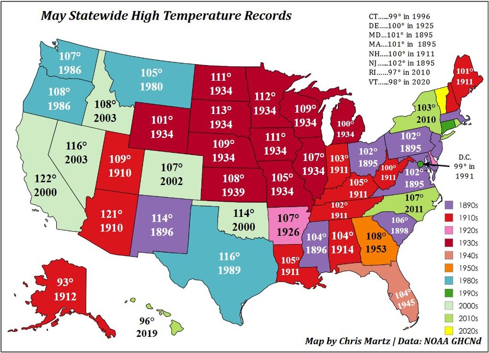
35 (70% of) U.S. states recorded their “all-time” high May temperature records before color TV in 1960! Of that subset, 21 of them were set over a century ago. In 1934, 10 states set their “all-time” May monthly high temperature records. In 1895 and 1911, seven and six states, respectively, set theirs.
-
Sounds like a Cyclical Climate Denier spin.......
-
Classic convergence. It's a good thing that LP has remained pretty weak
-
My neighbor refuses to have his gutters cleaned even though we back up to woods. During the last rain event here the water was pouring over the gutters enough to cause a crater in his yard. If this next event comes in hot like it is looking I'd imagine a doomsday scenario for his pavers and foundation. GFS and Euro both have about 2.4" for MBY
- Today
-
90s wont happen for awhile.. low 80s could though in some spots
-
I suppose in your world it is a summery look. Seeing as how 62° verifies a 65 to 70 forecast. If you hit a 81 over the weekend it's really 85 to 90.
-
66 / 37 clear / mostly sunny. Likely the nicest driest/sunniest of the next 6 days (thru Sat). Trough cuts off over the south east and slowly drifts north Tue - Fri with scattered showers, rain, clouds and cooler Tue - Wed, then warmer more humid Thu/Fri with rainfall 1 - 2 inches. Sat is iffy with front coming through and potential storms - not a washout. By Sunday back to 80. 5/19 - 5/25 looks near normal with trough into the east. Still think we may squeeze a brief hot day or two in the final 1/3 of the month but overall near normal close as is forecast now.
-
sunlight maxes out in 40 days then we start heading the other way again..
-
Yes, way too much rain in the summer. Fall was very dry, but usually a dry fall is a bad sign as it hints at what the winter will be like.
-
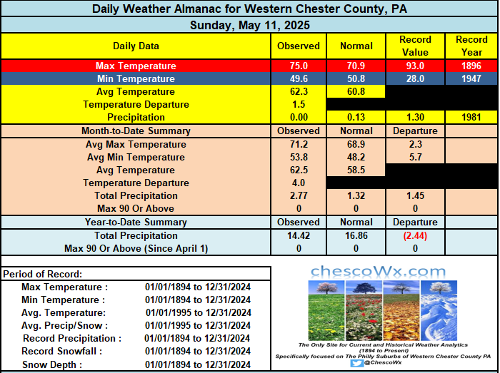
One more beautiful day before we see a stretch of wet weather that will last through most of the week. Some models show near an inch of rain by Wednesday morning. This week may well get us to close to normal rainfall for the year to date. Today we will see highs in the above normal upper 70's. We cool down to the upper 60's both Tuesday and Wednesday before we warm again toward the end of the work week.

-

E PA/NJ/DE Spring 2025 Obs/Discussion
ChescoWx replied to PhiEaglesfan712's topic in Philadelphia Region
One more beautiful day before we see a stretch of wet weather that will last through most of the week. Some models show near an inch of rain by Wednesday morning. This week may well get us to close to normal rainfall for the year to date. Today we will see highs in the above normal upper 70's. We cool down to the upper 60's both Tuesday and Wednesday before we warm again toward the end of the work week.
-
we might even get a few warmer or humid days.. but overall pretty meh.. maybe after the first week of June by the looks of it
-
This!
-
I posted the GEFS and EPS what more do you want
-
It’s not a summer look. Nice for May.
-
Timing on Euro is actually similar, the only thing I don't like is that it could extend into the night time. Don't need night time tornadoes.
-
hit 35 here. Covered up the sensitive stuff just in case. The extra week and a half in the ground was worth the small amount of effort.