All Activity
- Past hour
-

Monday, October 20, 2025 Squall Line Potential
CoastalWx replied to weatherwiz's topic in New England
Maybe right on S coast can watch. Looks meh outside that. -

Spooky Season (October Disco Thread)
kdxken replied to Prismshine Productions's topic in New England
Perfect! Could do without the rain though. -

Monday, October 20, 2025 Squall Line Potential
Damage In Tolland replied to weatherwiz's topic in New England
Looks pretty wild Monday AM -
Spooky Season (October Disco Thread)
Damage In Tolland replied to Prismshine Productions's topic in New England
Warm and bore . As far as can see -

Central PA Fall Discussions and Obs
mahantango#1 replied to ChescoWx's topic in Upstate New York/Pennsylvania
-
06z gfs may be even worse. That shows like 10 straight days of TS/ hurricane impacts?
-

Occasional Thoughts on Climate Change
donsutherland1 replied to donsutherland1's topic in Climate Change
Science does not treat models as faith. Neither do I. Models are tools that represent physical processes, tested against data, improved through hindcasting, and used to estimate probabilities. The comment confuses trust in validated methodology with blind belief. Uncertainty in basic areas concerning whether temperatures will increase , sea level will rise, ice will melt, is low. Uncertainty about amounts exists, but it isn’t so great that it justifies inaction. -
Here we go

-
Meanwhile IAH is 4.8 above normal and has had no rain at all yet in October.
-
6 IP with 10 Ks and he hit 3 homers!
-
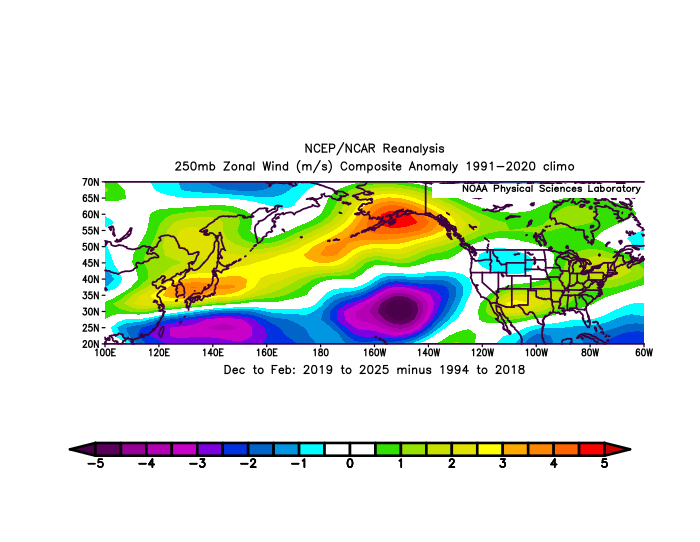
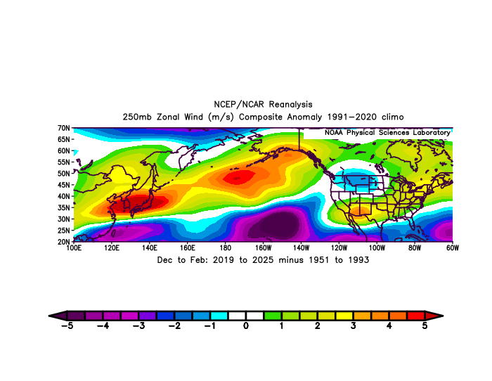
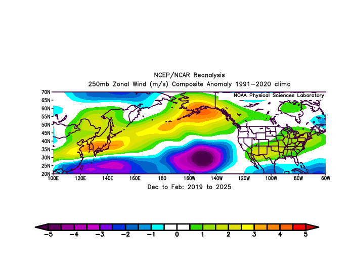
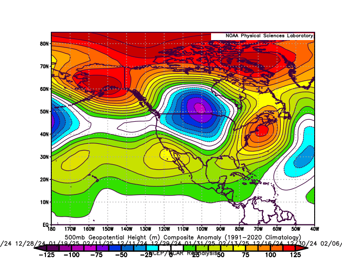
It’s the much stronger North Pacific Jet stream since 2018-2019 leading to the dominant Great Lakes cutter, I-78 to I-84 hugger, and suppressed Southern Stream storm tracks. So the DC to Philly corridor has had their lowest 7 year combined snowfall on record. Only a brief break in this pattern during 20-21 and January 22. January 22 was the last winter month with well above average snow and cold for our area. The 4th chart below is the storm tracks for last winter which lead to the much below average snowfall again. On the 11 days that .25” of precipitation fell in NYC we had a strong Southeast ridge and an average temperature of 41.0”. Fastest 7 year North Pacific Jet stream on record Warm storm tracks from last winter with a strong Southeast ridge on the 11 days that .25 of precipitation fell
-

Spooky Season (October Disco Thread)
Lava Rock replied to Prismshine Productions's topic in New England
Projected 1" for all of next week is weak sauce and will do nothing Sent from my SM-S921U using Tapatalk - Today
-
Spooky Season (October Disco Thread)
CoastalWx replied to Prismshine Productions's topic in New England
Boredom -
Monday, October 20, 2025 Squall Line Potential
CoastalWx replied to weatherwiz's topic in New England
Meh -
Yes. It is a category 5 (beyond extreme) marine heatwave and I think it’s being completely overlooked in regards to this upcoming winter. A marine heatwave this extreme is going to dramatically alter the global heat budget and I think it’s going to play a way bigger role than most people expect. Just like the extreme marine heatwave north of Australia that was totally overlooked back in the fall of 2019 and it ended up playing a very big role in the 2019-20 winter (++IOD)
-
Okay cold front is supposed to hit Sunday. We need wind gusts to 50, and lows need to plummet to 37 instead of a hot 49 Sunday night. I officially want another February 2021, cold as heck, maybe even colder but with lots rain and maybe a touch of snow. I am sick of hot weather! I want to get drowned by heavy rain and frozen solid by abnormally frigid temps down here! It's about time! I am sick and tired of the Dust Bowl. I crave Waterworld. I want water everywhere alongside frigid cold wet winds blasting HARD straight out of the North. Enough of August in late October.
-
I’ve been so bored during this amazing weather. The boomers right now are making me feel good feelings. Imma just chill and enjoy the show. Great light show with c2c and thunder. Chill.
-
Man doesn't your house have a bathroom?
-
The mistake you are making, is thinking that the move date is important. Coatesville cooled by roughly 2F relative to the other local stations after World War II, indicating a major station change. I substituted 1949 for 1948 in the Coatesville move table. The change increased the move-related cooling at Coatesville from 1.7 to 2.4F. The Coatesville move is complex: a big move in 1946 and a smaller one in early 1948. You only see a small part of the move by comparing 1948 to 1949. Note that Phoenixville also moved to a cooler location in 1949. So can't be used to estimate Coatesville station changes between 1945 and 1949. Since you have provided your “True Actual Average “ for the 1945 to 1950 period. Lets see how well you and NOAA match the station data for that period. I have separated stations into two groups, stations with moves and the stable stations without moves. The stations without moves show that there wasn't much local temperature change between 1945 and 1950. Those stations are only 0.2F cooler on average in 1950. In contrast, the 2 stations with moves, Phoenixville and Coatesville, cooled by 2F on average. Cooling at these stations is spurious, caused by station changes not weather. NOAA captures our local weather well, matching the stable stations very well. In contract your “True Actual Average” cooled by 1.4F much larger than the weather-related difference between 1945 and 1950 captured by the stations without moves. Station changes at 2 of the 4 Chesco stations active in this period contaminate your results. For all your complaints about NOAA, you are the guy who is altering our past weather. Introducing a phantom, move-related, "cooling cycle". The difference between your results and NOAA's highlights the importance of bias adjustments in Chester County. Our COOPs experienced one change after the other. Finally why is NOAA warmer than the 1940s coop station population? Easy, the 1940s stations are warmer than the county as a whole due to their location in built up towns. When they moved out of towns they cooled. Notice that Coatesville matches NOAA exactly in 1950. Makes sense, the new rural Coatesville location is more representative of the county as a whole. NOAA isn't fooled by station moves, that's a rookie mistake.
-
how much snow did you get? we had a nice surprise too-- around 6.5 inches here and 4.5 inches from another storm in the same week!
-
international shipping also adds a gigaton to greenhouse warming
-
wow March 2014 was such a waste after such an excellent winter, look how cold it was and only 0.1 inches of snow. February 2015 and March 2015 are why I remember 2014-15 as a much better winter than 2013-14.
-

Spooky Season (October Disco Thread)
ineedsnow replied to Prismshine Productions's topic in New England
Let's get one of these to work out
-
Mysterious 'warm blob' breaks records in the North Pacific Ocean https://www.bbc.com/news/articles/ce3xynwwx4yo
-

E MDR AEW: models support Car. TCG next wk
Floydbuster replied to GaWx's topic in Tropical Headquarters
The 00Z GFS would be a massive disaster for Haiti.


