All Activity
- Past hour
-

2025-2026 Fall/Winter Mountain Thread
Maggie Valley Steve replied to Buckethead's topic in Southeastern States
Looking like the 12Z GFS agrees with the 3km NAM regarding the snowfall possibility. -
Alright, who decided to do a funny?
-
Out of town but I think 2-3" from my cameras.
-
The models have already begun to back off the blocking
-
Temp here has shot up to 54 degrees courtesy of humid southeast winds. You wouldn't know blizzard conditions were in the offing in less than 12 hours.
-
They have a shot at 400”
-

3/16/26 Severe Weather Event Thread (Day 2 MOD Risk)
aldie 22 replied to Kmlwx's topic in Mid Atlantic
Just gonna ignore all that blue on the 3k nam? -
 CAPE changed their profile photo
 -
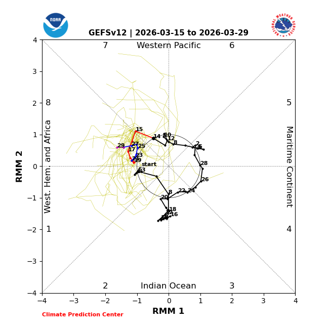
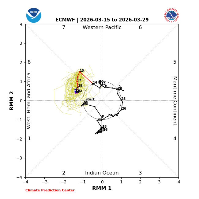
MJO forecasted to be in phase 8 most of rest of March. On average during Marches that were post La Niña winter, phase 8 was the 2nd coldest to phase 7 in Baltimore meaning being warm in the Mid-Atlantic/NE for the period averaged out will not be favored (note that I’m not saying anything explicitly about snow here as it’s getting late for that, especially MidAtlantic): GEFS: EPS: @EastonSN+
-
Not looking forward to it. The ground water level is like an inch below the surface here. Every sump pump and dehumidifer in the neighborhood has been running like crazy. How's it out that way?
-
Why? The NAO and AO are going negative…
-
that's probably going to be close to reality. Not bad
-
Yesterday’s NAO fcast had clear majority of members going <0: Today’s NAO fcast: only ~50% go <0 AO comparisons are similar. What will the next few days show? This is pretty volatile.


-
Yoopers will be buried with the snow already on the ground.
-
Why is it that heavy snow/blizzards don't convey well on camera - even 4K? Its never like seeing it IRL.
-

3/16/26 Severe Weather Event Thread (Day 2 MOD Risk)
Interstate replied to Kmlwx's topic in Mid Atlantic
It would be crazy to have that severe thunderstorms squall line go through, and have an end as sleet and snow -
CWG sounding the alarm with a couple of articles.
-
models really wet for CT tomorrow-2-4 inches of rain
-
The problem with these big midwestern winter storms is this. We think snow maps drive hype here...it's a million times worse out in those areas. Snow maps out there can go absolutely off the charts in these setups and will show these widespread 20-30+" totals when the max zone ends up being something like 15-20" with some localized higher totals. It's a constant theme with these garbage products yet people still flock to them. People must love being wrong for some odd reason
-
Worst tornado outbreak in the Carolinas since March 1984 maybe?
-
Somebody already has 21" and there's a severe thunderstorm warning next to some 30 degree temperatures
-
The NAM may be overdone to a degree as its steeper with the mid-level lapse rates and thus is a bit beefier with elevated CAPE. Such an interesting forecast though because with dewpoints potentially pushing well into the 50's we may not be as inverted as you'd think given the setup and time of year. One big flag, however, is the column should be rather saturated which is never really good for big wind. Outside of the typical spots, any gusts 50-60+ mph would probably have to be tied into any stronger convection moving through. But I am not sure we'll see much strong convection with the overnight stuff.
-
MET from Central IL posted this. Would think this would extend north and east too? https://www.facebook.com/share/17Ay3SJdeN/
-

3/16/26 Severe Weather Event Thread (Day 2 MOD Risk)
NorthArlington101 replied to Kmlwx's topic in Mid Atlantic
Tomorrow is an obvious evening activities canceled for local school systems. Trickier call to early release depending on when the squall line is. I’d guess most schools pull the trigger. -
chicago updated We have opted to upgrade the Winter Storm Watch across our northwest to a Winter Storm Warning from 7 pm this evening through 1 pm Monday. We strongly considered a Blizzard Warning, but have opted to hold off on that at this time, though cannot rule out the need to upgrade as the event unfolds this evening. Either way the combination of falling and accumulating snow with widespread blowing snow and gusty northwest winds (up to 50 mph) will make for near blizzard conditions at times tonight into Monday morning across northwestern IL. Total snowfall amounts in the warned area are expected to be in the 3 to 6 inch range. In addition to the warning, we have also opted to issue a Winter Weather Advisory from 10 pm tonight through 1 pm Monday for areas east-southeast of the Winter Storm Warning. This basically includes areas nearly as far southeast as the I-55 corridor. Snowfall amounts in this region are expected to be lighter, generally in the 1 to 3 inch range. However, the combination of the snow and blowing snow will also make for hazardous conditions outside of the Warning area Monday morning.
-
I would guess LWX will issue a special weather statement later highlighting the risk. They put one out for the line that blew down all the power lines in Westminster in that moderate risk event like 3 years ago.