All Activity
- Past hour
-
Yes apparent temp is a combo map. It's heat index when it's hot, wind chill when it's cold. All credit goes to @wxmeddler
-
regional round up: BOS at 91 (low of 78) EWR is at 96 already lol (low of 82) NYC at 94F (low of 82) - should be the first 100 there since the 2010s LGA at 94F (low of 84) - the Queens/Brooklyn heat island is absolutely fierce. PHL at 94F (low of 80) This is a proper Acela corridor heat wave.
-

2026 Mid-Atlantic Severe Storm General Discussion
dailylurker replied to Kmlwx's topic in Mid Atlantic
Justin Berk is honking on a flood threat for Sunday and Monday. -
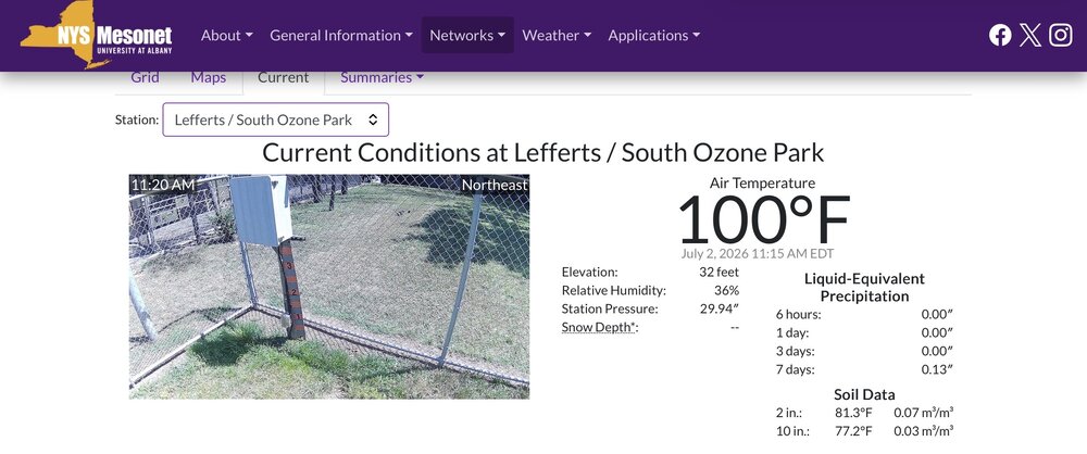
Lefferts/South Ozone Park now at 100.
-
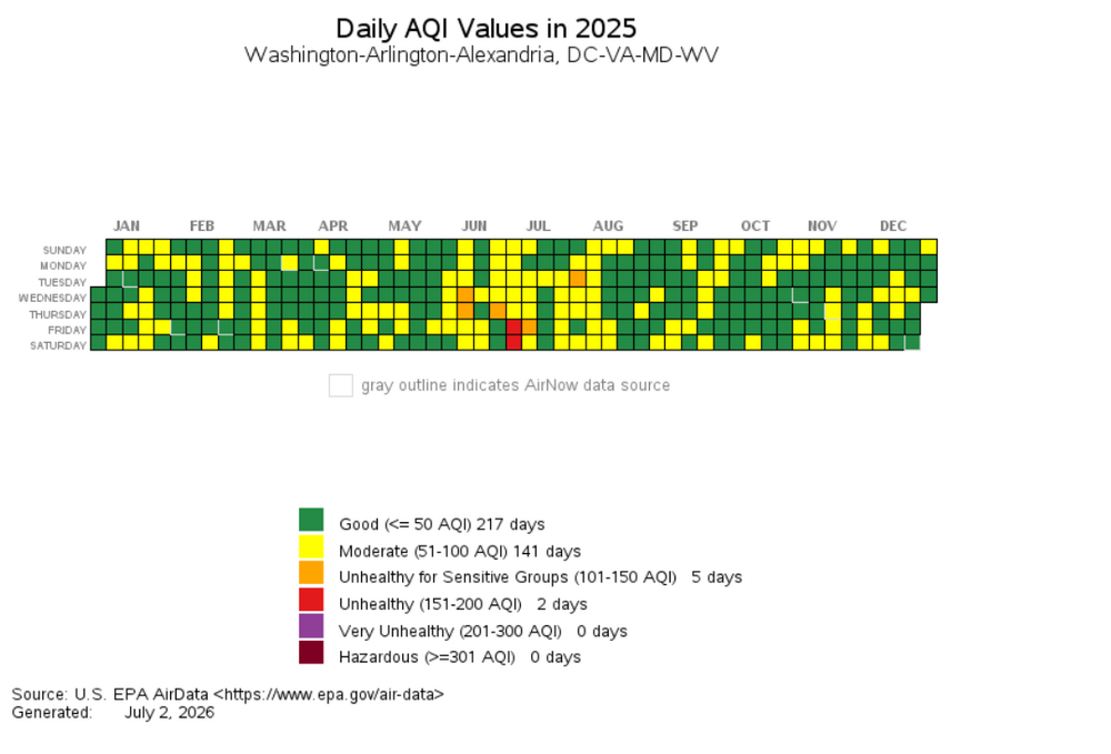
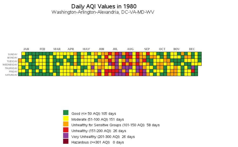
Hear hear - I work in urban planning so think about this stuff a lot. 2025 versus 1995 for the AQI... great visualization tool on this page https://www.epa.gov/outdoor-air-quality-data/airdata-tile-plot (which I think I got off this site years ago). sorry for the digression.. edit - adding 1980 for fun - thanks clean air act
-
DCA at 95 now.
-

E PA/NJ/DE Summer 2026 Obs/Discussion
Joshb32689 replied to PhiEaglesfan712's topic in Philadelphia Region
91/78 outside of Coatesville as of 1115am. Thinking we don’t break 100 today That 106 heat index is something else though -
Yeah, it's really strange, because you would expect downsloping to produce lower DPs in the western Piedmont not higher
.thumb.png.b822878da2da249afac8b29cfd045e25.png)
-
Already 97 in Crofton and 96 here east of Crofton in the woods. Wild DP and heat in the South River watershed.
-

2026-2027 Super El Nino
40/70 Benchmark replied to Stormchaserchuck1's topic in Weather Forecasting and Discussion
Yes, it will be better, but the question is how much better...as Chris says. -
Just north of there working. Can confirm. Its cooking and im already soaked lol
-

2026-2027 Super El Nino
MarcmmKU replied to Stormchaserchuck1's topic in Weather Forecasting and Discussion
For anyone on the I95 the 2030s should be significantly snowier than the 2020s. Hard to do worse than rock bottom. -
My son and I did 45 mins outside working on the deck. That was plenty. Shirt soaked in sweat.
-
I was assuming that we were looking at more of a 2024 or 2010 like heat where the focus wasn’t on the humidity, but this is damn near 2011.
-
yeah if this was back in the 90s, there'd be crazy alerts.
-

E PA/NJ/DE Summer 2026 Obs/Discussion
TheClimateChanger replied to PhiEaglesfan712's topic in Philadelphia Region
Wow! 114°F heat index! -
2026-2027 Super El Nino
40/70 Benchmark replied to Stormchaserchuck1's topic in Weather Forecasting and Discussion
I expect something similar temp wise, but snowfall in the higher terrain of northern New England is still a bit of a wild card. Not a pretty look overall for December, though. -
98/74 HI 111
-
Mesonet picking up a DP of 79 with air temp 94 in college park. cooking. "apparent temp" (is that heat index? @Eskimo Joe) 111! @dailylurker are you doing a heat hike
-
 Impressive but probably short of all-time records. They've reached 96 on 4 occasions, May 1977 and June 1944, 2020, 2024. Those peaks came with lower dews than the current condition, and cooking water likely will modify the heat. Their temp only rose 4° between 9 and 11, currently 86 with TD 71, so 90-02 looks better than 96 (unless mixing brings the dews to low 60s). However, if the morning low of 74 holds, that will be their record mild minimum, currently 71 reached a half dozen times.
 -
yep - gotta think in Celsius (bc of the backwards way they do the F -> C -> F conversion): 98.6 -> 37C 100.4 -> 38C 102.2 -> 39C 104 -> 40C 105.8 -> 41C
-
IAD 93/76 at 11am.
-
98/74. It's not even noon.
-
DCA is 94/76 at 11am. Absolutely brutal.
-
DCA actually hit 100 a few times in 2024 with a south wind, so it still can happen.


.png.96974298f8ec1a279f53f6b2cdbe468e.png)


