All Activity
- Past hour
-
This has been my idea since Thursday. Since then, my confidence has decreased, not increased. But I’ll let it ride and go down with ship if need be. Meanwhile, I’ll be at the whiskey & chocolate fest in Oaks today picking up storm supplies.
-

“Cory’s in LA! Let’s MECS!” Jan. 24-26 Disco
SeanInWayland replied to TheSnowman's topic in New England
Thank you for this, I was always wondering what the Kuchera algo was, and what it was good for given the many comments. Your synopsis begs the question, why is your preferred approach not available as an algorithmic output? . -

“Cory’s in LA! Let’s MECS!” Jan. 24-26 Disco
Prismshine Productions replied to TheSnowman's topic in New England
Do we even have a nickname for the RRFS yet? Seems we got one for all the others Goofus- GFS King/Dr.No- Euro Reggie- RGEM ICONic- ICON (Looking at you Astronomer) Uncle- UKMET Nammer- NAM (And I personally call the GEM "Ol' Timbits") Sent from my SM-S166V using Tapatalk -

Jan 24-26 Weekend Snow and Sleetfest Model Thread Part Tres
Bob Chill replied to H2O's topic in Mid Atlantic
Decent virga on radar down this way keeping me entertained for now lol Forecast start time pushed out to 7-8pm so we'll see how that breaks later. Some areas of TN are overperforming in the snow depth so that's a glimmer of hope but I'm not feeling optimistic about 4" of clean snow anymore. Time will tell. Ice amounts have bumped up in my area as well. I'll keep posting until I lose power and internet lol. -
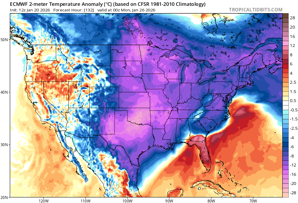
Low of 11 here and -8 at Deep Creek. It’s so nice not sweating high temps today.
-

Extreme Cold, Snow & Sleet: SECS 1/25 - 1/26
eduggs replied to TriPol's topic in New York City Metro
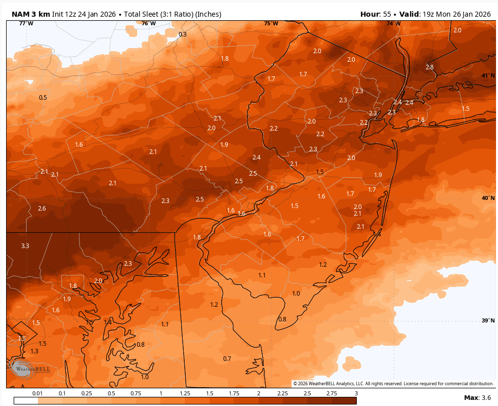
We go through this so often. And people cover their eyes and ears beforehand and pretend it didn't happen afterwards. When the NAM shows sleet it sleets. And the extent is usually north of where the 3rd party vendor graphics show it. -
(002).thumb.png.6e3d9d46bca5fe41aab7a74871dd8af8.png)
January 25-26 Winter Storm Potential
ChescoWx replied to Ralph Wiggum's topic in Philadelphia Region
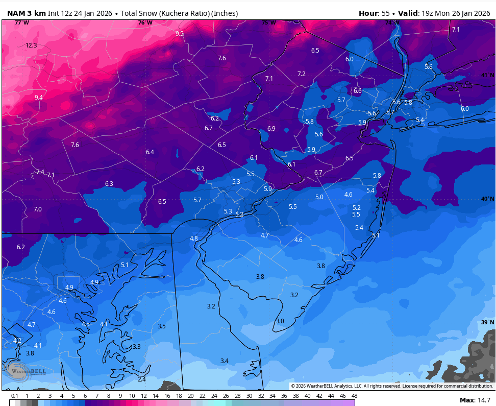
Across Chesco I think a solid 7" to 10" (SE to NW) of snow (6" - 8" snow/and 1" to 2" of sleet) with some ZR snizzle at the end. NAM leading the way

-

Jan 24-26 Weekend Snow and Sleetfest Model Thread Part Tres
Maestrobjwa replied to H2O's topic in Mid Atlantic
So in other words...just bad luck with the track, smh -

“Cory’s in LA! Let’s MECS!” Jan. 24-26 Disco
Damage In Tolland replied to TheSnowman's topic in New England
There’s 7” on the ground here .. if we can add 15-20” and then more on Thursday the pack will be best since 2015 -
Looks like most all the modeling so far has bumped a bit north so we are now getting into the 1 inch QPF range up here.
-

Arctic Hounds Unleashed: Long Duration Late January Cold Snap
WxWatcher007 replied to WxWatcher007's topic in New England
It looked like an extremely fine fog but it wasn’t particularly dense. Hmm…I mean I’ve seen us snow in virtually clear air conditions so idk. I’m new to all this so it’s pretty cool learning about what to spot. -
Looks like we have major differences between amounts on RAP and NAM compared to HRRR for the Piedmont of NC. Anyone have thoughts on which typically performs better in this scenario?
-

Central PA Winter 25/26 Discussion and Obs
Voyager replied to MAG5035's topic in Upstate New York/Pennsylvania
Thanks! Some of those 2010 storms skunked the Skook if I remember right. As for the blowing and drifting, any place that doesn't taint is going to have problems into Tuesday, I think. -
“Cory’s in LA! Let’s MECS!” Jan. 24-26 Disco
Damage In Tolland replied to TheSnowman's topic in New England
That’s probably about dead nuts on -

Winter 2025-26 Medium/Long Range Discussion
A-L-E-K replied to michsnowfreak's topic in Lakes/Ohio Valley
Zzzzzzz -

January 25-26 Winter Storm Potential
Violentweatherfan replied to Ralph Wiggum's topic in Philadelphia Region
But this storm is/was fascinating to watch evolve and learn from -

Central PA Winter 25/26 Discussion and Obs
pasnownut replied to MAG5035's topic in Upstate New York/Pennsylvania
As this has an overrunning component to it I sorta expected things to maybe show up a bit ahead of schedule. -
“Cory’s in LA! Let’s MECS!” Jan. 24-26 Disco
Damage In Tolland replied to TheSnowman's topic in New England
If things keep ramping you may need to do a 15-22 or something inland -
Looks like definite sleet to me on soundings.
-

Jan 24-26 Weekend Snow and Sleetfest Model Thread Part Tres
RDM replied to H2O's topic in Mid Atlantic
Seems the warm nose is even more pronounced that last night. Would appreciate an explanation from a red tagger or one of our more experienced members how the warm nose at 700 (or 750 - wherever it is) can be so shallow, but project so far out with the uppers and surface remaining cold - especially the surface. Is this a physics thing with fluid dynamics or what? -

Extreme Cold, Snow & Sleet: SECS 1/25 - 1/26
Astoriaweather replied to TriPol's topic in New York City Metro
I am thinking 5 to 8 in NYC, but at this point I will be satisfied with that, especially if the sleet helps it form into a glacier afterwards. . I guess my one worry is that things just keep trending bad until game time and even 5 is not within reach in the urban, coastal core. Hope I am wrong. -

Jan 24-26 Weekend Snow and Sleetfest Model Thread Part Tres
CAPE replied to H2O's topic in Mid Atlantic
More phasing/amplification allows the primary low to track further north with a later transfer to the coast- and the developing coastal low is tucked. Earlier runs were less amped/ w flatter flow, a weaker primary with earlier transfer further south and the coastal low tracking ENE off the coast- this setup spares the area from too much warm air moving in aloft and at the surface in the vicinity of the coastal low. The warming is temporary as the colder air comes back in afterwards.

-
1/24-1/25 Major Winter Storm - S. IL, IN, and OH
TimChgo9 replied to A-L-E-K's topic in Lakes/Ohio Valley
Watching developments for S OH with trepidation. NAM shows 8-10”. All others GFS, HRRR, RAP, and Euro show in excess of 12” up to 22”. I fear the NAM may be on to something. I hope I’m wrong. -

Jan 24-26 Weekend Snow and Sleetfest Model Thread Part Tres
Heisy replied to H2O's topic in Mid Atlantic
I’ve been mentioning 12/20 for 4 days now over on our discord. It’s in the top 5 of analogs as of yesterday. . -

2025-2026 New England Snow Recordkeeping Thread
codfishsnowman replied to bristolri_wx's topic in New England
1.6 on Thursday brings me to 19.4 inches for the season. Not bad on snow and pretty darn chilly at times with frequent freshening breezes. Looks as though we have around a general 3 inches on the ground before Sundays event begins