All Activity
- Past hour
-
DVN just gusted to 59mph. Should be another very nice soaker en route.
-

Augdewst 2026: Summer's Last Stand
dendrite replied to Prismshine Productions's topic in New England
Gotta love BOS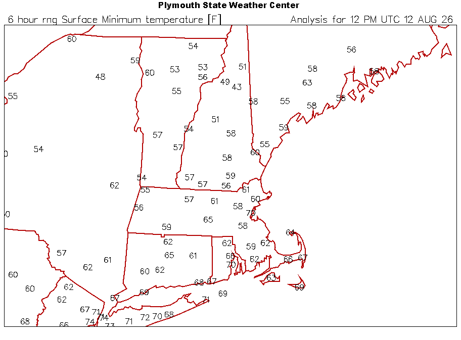
-

2026 C and E Pacific tropical activity
Kevin Reilly replied to GaWx's topic in Tropical Headquarters
My friend's plane leaves for Honolulu Hawaii Friday, August 14th. He is taking a Hawaiian island cruise around all the islands. Looks like the GFS has a 985 mb storm and the Euro 997 mb storm making a direct hit on the big island before moving west and away. Looks like this system is a legitimate threat to Hawaii. Any updates from the more seasoned tropical guys here would be great. I am able to see the models and the water vapor maps / satellites etc. looks like a bit of shear and dry air to the north limiting development for now. Looks like the legitimate threat lies at 11 N and 143 W if I am looking at it correctly but almost looks like another up there at 15N and 139 W. It looks very active out there. -

Occasional Thoughts on Climate Change
Typhoon Tip replied to donsutherland1's topic in Climate Change
Btw, Europe is quickly closing on a JJA warmest ever for a second consecutive year. I'm not sure if that's on whole, or in lesser quadratures but just a-priori on the story-line to date proooobably implicates everywhere? I dunno on that per se. interesting tho -

2026-2027 Record-breaking El Nino
jconsor replied to Stormchaserchuck1's topic in Weather Forecasting and Discussion
You can find VP anomaly from 1940s to present from JMA 3Q reanalysis here: https://ds.data.jma.go.jp/gmd/tcc/tcc/products/clisys/figures/db_hist_jun_tcc.html (10 day means) https://ds.data.jma.go.jp/gmd/tcc/tcc/products/clisys/figures/db_hist_mon_tcc.html (monthly means) In the menu on upper left under "Field", click on Tropics. Then under Element, click 200 hPa Velocity Potential. -
 I asked Gemini these three questions, italicized for clarity. You could ask any AI the same set of questions, and get the same general answers. Q: For collecting good-quality long term climate temperature data, 100 years+, describe a hypothetical location in a temperate climate. Short answer. A: A ideal hypothetical location in a temperate climate for a 100-year climate station is an isolated, protected rural valley plateau. Q: If you took the station just described, and after 100 years of data, moved it into an urban area, what would happen? Short answer. Describe the reverse case as well, where the station begins in an urban area. A: Moving a Rural Station to an Urban Area: Moving a 100-year rural station into a city causes an artificial temperature spike. A: The Reverse: Moving an Urban Station to a Rural Area: Moving a station from a city out to a rural area causes an artificial temperature drop. Q: How would you correct for the station move? A: To correct for a station move, climate scientists use a statistical process called homogenization. Here is how the correction works: Create a Reference Record: Scientists select a group of nearby, undisturbed "neighboring" stations that experienced the same regional weather but did not move. Identify the Breakpoint: They calculate the average temperature difference between the target station and the neighbor group. A sudden, permanent shift in this difference confirms the exact date of the move. Calculate the Offset: Scientists compare the data from a window of years immediately before the move to a window of years after the move against the stable neighbors to determine the exact bias (e.g., the city move made it 1.2°C warmer). Adjust the Historical Data: They apply that 1.2°C offset to the entire block of data prior to the move, lifting (or lowering) the old record so it seamlessly aligns with the new location's environment.
 -
Storms possible mainly north and west area this evening/later tonight
-
It's kinda boring not having any tropical to track this time of year. No big swells, no cone of uncertainty, no weenie NAM runs with a cat 5 into Annopoils. Nothing but dust and cobwebs.
-
There's almost a chill in the air this morning
-

Augdewst 2026: Summer's Last Stand
CoastalWx replied to Prismshine Productions's topic in New England
Thankfully we upper 60s. -

2026-2027 Record-breaking El Nino
GaWx replied to Stormchaserchuck1's topic in Weather Forecasting and Discussion
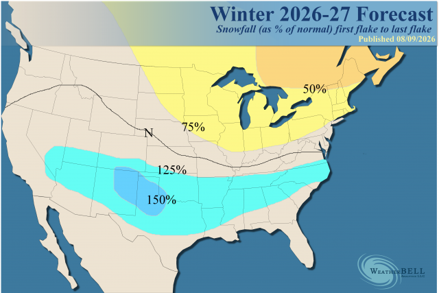
Initial WxBell Nov ‘26- Mar ‘27 forecast looks very reasonable although I’d like to see the month to month so as to see the expected large variability from early to late as I’ve just been posting about although they did say this: The bottom line is the colder part of the winter is expected to be later, rather than in December. Temps: Snowfall: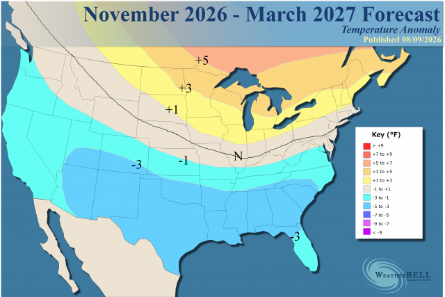
-
Augdewst 2026: Summer's Last Stand
dendrite replied to Prismshine Productions's topic in New England
Min 57.4° Coldest 8/12/2026 of my life. -
The TW following 92L is also making some noise on the models and is now a lemon although the 0Z UKMET has it just as a TW moving similarly to 92L into the E Caribbean: 8AM TWO: Now up to 20/30:3. Eastern Tropical Atlantic:A tropical wave just offshore of the coast of west Africa is producing disorganized showers and thunderstorms. Environmental conditions are forecast to be generally conducive for some development of this system during the next several days while it moves westward or west-northwestward across the eastern and central tropical Atlantic.* Formation chance through 48 hours...low...20 percent.* Formation chance through 7 days...low...30 percent.
-

2026-2027 Record-breaking El Nino
bluewave replied to Stormchaserchuck1's topic in Weather Forecasting and Discussion
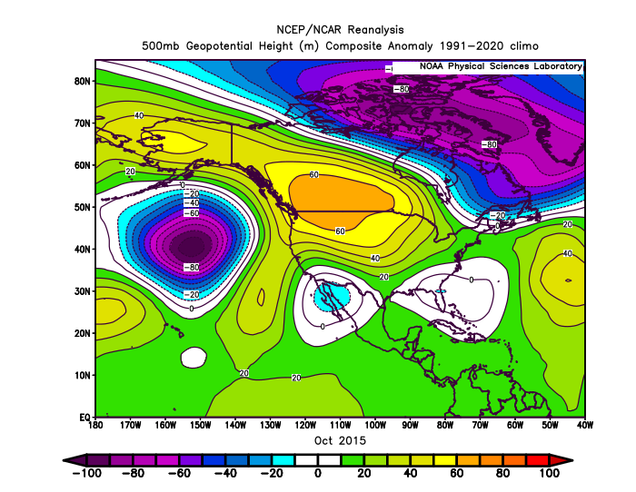
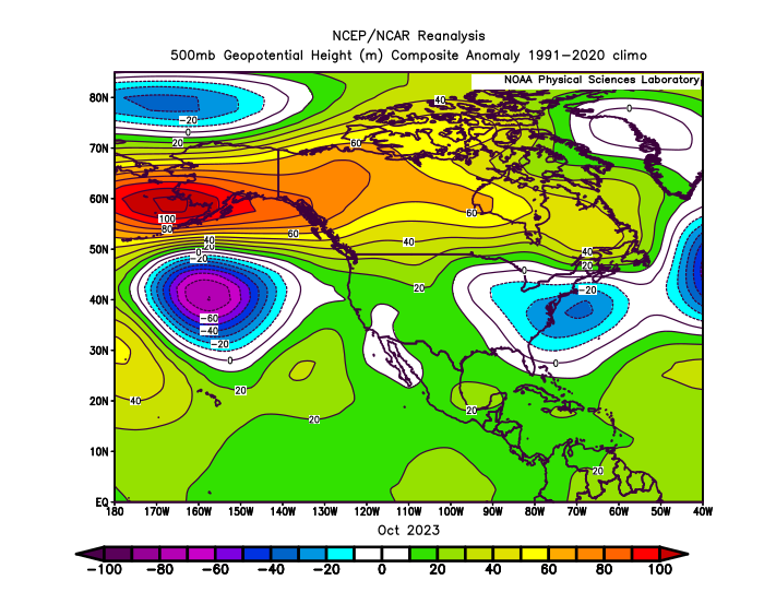
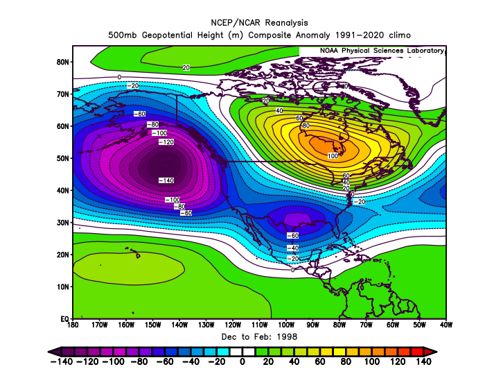
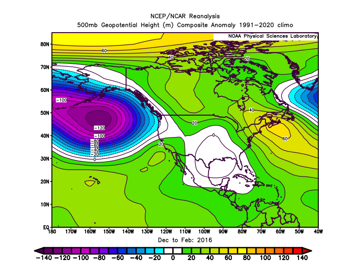
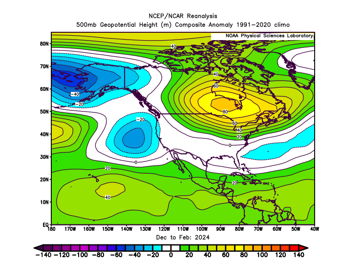
Yeah, October has been a pretty good indication of the Aleutian low strength for the winter since 1997 during super El Niño. Notice how large an area in the NEPAC during October 1997 was occupied by the Aleutian low. It actually had multiple centers. One area NW of Hawaii and the other over the EPO and PNA regions. The Southeast El Niño trough was already beginning to become established also. That winter went on to have one of the strongest and largest Aleutian low areas of all-time. In October 2015 and 2023 the Aleutian low was confined to a much smaller space in the NEPAC. Both of theses winters had smaller and more displaced Aleutian low locations than 1997-1998. This matches the 500 mb ridges becoming stronger and more expansive since 2015-2016 and the troughs becoming weaker relative to earlier years.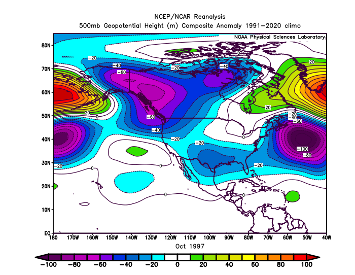
- Today
-
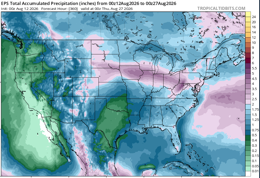
p strong agreement on more relief in droughtville
-
-

Central PA Summer 2026 Discussion/Obs Thread
pawatch replied to Voyager's topic in Upstate New York/Pennsylvania
63 degrees this morning. Fishing yesterday pretty hard downpour 6:00am for 15 minutes and some strong winds. We took fish place yesterday. Been a tough year. -
should be a safe miss south for my, not to bummed and will be nice to see the wet get spread around a bit
-
 https://mapletrustrx.com/# Maple Trust Rx
 -
2026-2027 Record-breaking El Nino
GaWx replied to Stormchaserchuck1's topic in Weather Forecasting and Discussion
Thank you for adding Feb of 1995 and especially 2007 to the list. Indeed, two more cold Febs and they both had warm Decs! So, the idea continues to be that a warm Dec, which is expected especially up north and especially what @snowman19has emphasized and which El Niño climo favors, has little to no bearing on how cold Feb could be. That imho tells me the best way to look toward this winter, looking at its prospects month to month. Models and analogs are emphasizing the prospect for a big range from warm start to cold end. -

Spring/Summer 2026 Pattern Discussion Thread
Jed33 replied to Carvers Gap's topic in Tennessee Valley
That was an unusual MCS. It’s like it kept moving SE but storms kept developing on outflow boundaries that were pushing SW. Then quite a bit of convection just developed ahead of the main line to the west and SW of Knoxville extending all the way back to middle TN. That looked like some really intense rainfall and lightning around Knox Co. last night around 10-11 PM. Here I picked up 0.79, but some places had alot more. Now, there is another one knocking on the door again this morning. FFW today for a good chunk of E TN. -

Occasional Thoughts on Climate Change
donsutherland1 replied to donsutherland1's topic in Climate Change
The Dust Bowl was a regional phenomenon focused largely on the Plains and Midwest (location of the extreme drought amplified by poor land use/farming practices). Heat occasionally spread outside that region. New York City's 106° record is one example. The heat was so intense that the contiguous United States recorded its hottest month on record in July 1936. That record has fallen now. Slowly but inexorably, as temperatures continue to rise, some of the site records from 1936 in the Plains and Midwest are also being erased. Over the next few decades, many more of those records will likely be eclipsed. It's plausible that the July 2026 mark will be surpassed one or more times in the next 10-20 years. -

2026-2027 Record-breaking El Nino
EasternLI replied to Stormchaserchuck1's topic in Weather Forecasting and Discussion
Top of the scale WWB on the 00z EPS. -

Central PA Summer 2026 Discussion/Obs Thread
mahantango#1 replied to Voyager's topic in Upstate New York/Pennsylvania
US National Weather Service State College PA Favorites ·r͏n͏d͏o͏e͏s͏p͏t͏S͏o͏a͏1͏5͏3͏l͏a͏7͏3͏0͏h͏5͏1͏2͏3͏i͏f͏4͏i͏6͏m͏8͏0͏0͏m͏m͏g͏0͏0͏0͏6͏g͏l͏3͏4͏7͏7͏5͏8͏5͏l͏1͏2͏t͏0͏g͏3͏l͏f͏i͏m͏ · Wednesday August 12th, 2026 @ 6:00 AM EDT Marginal Risk (1/5) for Severe Storms Today Locally severe storms could bring strong winds, heavy rain, and hail later today Lower confidence for our SW counties, though a shift in the Ohio Valley storm track may bring severe storms into those areas as well -
LGA came the closest at 99°. We could already begin to see the influence of the trees in Central Park after the new ASOS was installed in the shade in 1995. During the July 1991 heatwave Riverhead also made it to 100°. But the old Central Park station not under trees made it to 102°. Data for July 15, 1997 through July 15, 1997 Click column heading to sort ascending, click again to sort descending. NJ NEWARK LIBERTY INTL AP WBAN 101 NJ TETERBORO AIRPORT WBAN 101 NY RIVERHEAD RESEARCH FARM COOP 100 NY LAGUARDIA AIRPORT WBAN 99 NJ HARRISON COOP 99 NY MINEOLA 1 NE COOP 99 NY MINEOLA COOP 98 NY SETAUKET STRONG COOP 98 NJ CANOE BROOK COOP 97 NY NY CITY CENTRAL PARK WBAN 97 CT DANBURY COOP 97 NY WESTCHESTER CO AP WBAN 97 CT NORWICH PUBLIC UTILITY PLANT COOP 97 NJ CRANFORD COOP 96 CT STAMFORD 5 N COOP 96 NY WEST NYACK COOP 96 NY UPTON COOP - NWSFO NEW YORK COOP 96 NY BRIDGEHAMPTON COOP 96 CT MOUNT CARMEL COOP 96 NY ISLIP-LI MACARTHUR AP WBAN 96 NJ LITTLE FALLS COOP 95 CT IGOR I SIKORSKY MEMORIAL AIRPORT WBAN 95 NY SEA CLIFF COOP 95 NY PORT JERVIS COOP 94 NY NEW YORK AVE V BROOKLYN COOP 94 NY JFK INTERNATIONAL AIRPORT WBAN 94 Data for July 21, 1991 through July 21, 1991 Click column heading to sort ascending, click again to sort descending. CT DANBURY COOP 105 NJ NEWARK LIBERTY INTL AP WBAN 102 NY NY CITY CENTRAL PARK WBAN 102 CT MIDDLETOWN 4 W COOP 102 NY BRIDGEHAMPTON COOP 102 CT MOUNT CARMEL COOP 101 NY ISLIP-LI MACARTHUR AP WBAN 101 CT GROTON COOP 101 CT NORWICH PUBLIC UTILITY PLANT COOP 101 NJ CANOE BROOK COOP 100 NY NY WESTERLEIGH STAT IS COOP 100 NY LAGUARDIA AIRPORT WBAN 100 NY MINEOLA COOP 100 CT NEW HAVEN COOP 100 NY RIVERHEAD RESEARCH FARM COOP 100