
All Activity
- Past hour
-

2026 Mid-Atlantic Severe Storm General Discussion
Eskimo Joe replied to Kmlwx's topic in Mid Atlantic
Per SPC mesoanalysis, there's a pretty solid are of instability cresting the Allegheny Front. -
In tropical situations, it can be useful to use the virtual temp at the sfc instead of the dry bulb temp. Using it can represent CAPE better in such environments (virtual temp increases CAPE). 76 dew point is nothing to shake a stick at! Don't need too much heating for things to go and go well w/ that kind of juice.
-
Possible rain earlier than expected?
-
2026 Mid-Atlantic Severe Storm General Discussion
Eskimo Joe replied to Kmlwx's topic in Mid Atlantic
Use NAM MOS and HRRR together and you knew when the flip from SN -> IP -> RA would occur 90% of the time. That combination consistently schooled the GFS and Euro inside 30 hrs. -
Slightly wet ground. Is this it? Yesterday's forecast was for a half inch today and up to an inch tonight. LOL This has been a recurring trend with the forecasts here for months.
-
Yes, the NAM has some uses. It handles CAD much better than the GFS, as one example and its MOS reflects that. But the HRRR handles CAD well, so no loss there. Since it has more vertical levels than all the global models, its should handle mix zone better and we are used to that. But again, the HRRR and now RRFS should effectively replace that skill (eventually). Losing some for other gain happens. I recall NHC objected to an upgrade of the GFS some years ago b/c it was clearly shown that the upgrade made TC skill less for the EPAC basin. The upgrade was done regardless. So it's hard to please everyone!
-
Cooled off with the cloud cover and wind. First half of day was nice
-
I need to move to Frederick.
-
Got the Stephen’s city treatment so far today. Not even 0.1”, way less than most mesonet stations in central MD
-

Augdewst 2026: Summer's Last Stand
vortex95 replied to Prismshine Productions's topic in New England
-

2026 Mid-Atlantic Severe Storm General Discussion
SnowenOutThere replied to Kmlwx's topic in Mid Atlantic
Not the thread for this question, but is the conversation for it. I understand turning the NAM off for convective season, however, I don’t understand turning it off for winter short term stuff. I would love to know why, I assume it’s something in how it handles thermodynamics and WAA, but the NAM is almost always the most correct model when it comes to refining the mixing line in synoptic scale winter storms. It just seems odd to turn off a model which has a very useful edge on all others, even if it sucks at a lot of other aspects; could at least compromise and run it before major storms on the east coast. Would love to know your thoughts on both why it surpasses the other mesoscale models in the mixing line placement and how to compensate for its disappearance come winter time. -
It’s raining again today and rained yesterday. It’s rained almost every day the last 6 weeks. What a turnaround after a super dry first 6 months of the year
-
2026 Mid-Atlantic Severe Storm General Discussion
Eskimo Joe replied to Kmlwx's topic in Mid Atlantic
Latest HRRR puts a legit bow through Frederick/Loudoun/Montgomery/Carroll counties right at sunset.- 1,935 replies
-
- 1
-

-
- severe
- thunderstorms
- (and 7 more)
-

2026-2027 Record-breaking El Nino
GaWx replied to Stormchaserchuck1's topic in Weather Forecasting and Discussion
Thanks, Mitch. It has risen >1 in just 14 days! -
.thumb.gif.f92b16c631a1d15d405ed77b33f0710d.gif)
Augdewst 2026: Summer's Last Stand
Torch Tiger replied to Prismshine Productions's topic in New England
Perhaps we'll see a few showers/storms if an U/L digs across SE Canada next weekend. OTW very very dry -

Central PA Summer 2026 Discussion/Obs Thread
canderson replied to Voyager's topic in Upstate New York/Pennsylvania
.35” so far. We’ll see if we get more later this afternoon/evening. I have a doubt we do. -
Augdewst 2026: Summer's Last Stand
Torch Tiger replied to Prismshine Productions's topic in New England
Nasty dry day. At least it's sunny and mild -

2026-2027 Record-breaking El Nino
mitchnick replied to Stormchaserchuck1's topic in Weather Forecasting and Discussion
Still rising slowly..png.d5b398c08d1d08e6f3a9c79afd1444d9.png)
-
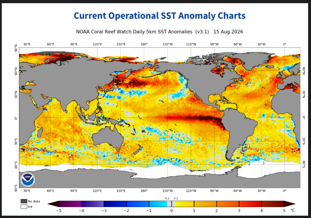
Looks like an El Nino tropical map to me
-
 It did in 1997 just a few weeks earlier this go around. I don't yet know why but feel this will peak earlier than expected.
 -
Last typhoon that hit East China warmed the SSTS off East Asia especially East off Japan.Still myself would rather to see the PDO right now to rise and not fall.We might be seeing a repeat of the pattern we are in as we get closer to end of August into Sept. That strong WWB ongoing along with the Rossbly Waves should really kick off some tropical storms in the PAC the next few weeks
.thumb.png.cc8bf4b5e6eac13e552394196481c421.png)
- Today
-

2026 Mid-Atlantic Severe Storm General Discussion
jewell2188 replied to Kmlwx's topic in Mid Atlantic
Seems as though on visible, clearing should progress west to east very shortly!- 1,935 replies
-
- 1
-
-
- severe
- thunderstorms
- (and 7 more)
-

2026 Mid-Atlantic Severe Storm General Discussion
midatlanticweather replied to Kmlwx's topic in Mid Atlantic
76/76 now but breezes from the south have been more steady and the lower foggy haze is lifting. Also seing very bright patches as the clouds seem to want to break up. Little patches of thinner clouds are showing up on satellite. We shall see if this enhances anything. Air is thick- 1,935 replies
-
- 1
-
-
- severe
- thunderstorms
- (and 7 more)
-
2026-2027 Record-breaking El Nino
GaWx replied to Stormchaserchuck1's topic in Weather Forecasting and Discussion
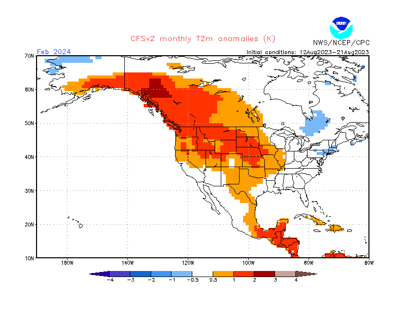
CFSv2 10 day run mean is still not backing off of a cold Feb in a large portion of the US, especially corridor from SE US to C Plains where most areas are a whopping 5-7.5F BN though I’d prefer Alaska and NW Canada be AN: Compare this to the same for Feb of 2024 from about the same 10 day mean in Aug of 2023: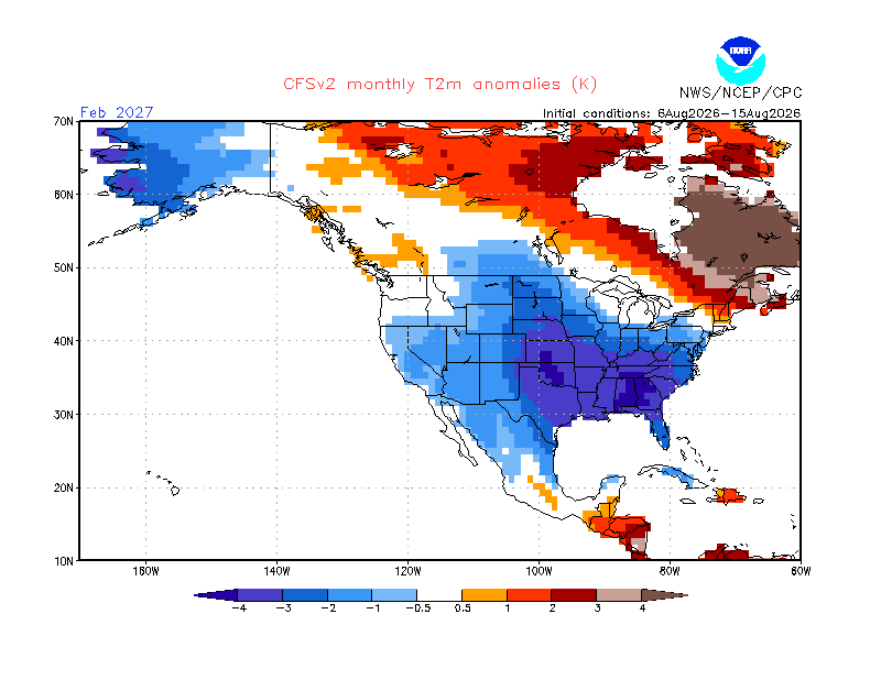
-

Augdewst 2026: Summer's Last Stand
Baroclinic Zone replied to Prismshine Productions's topic in New England
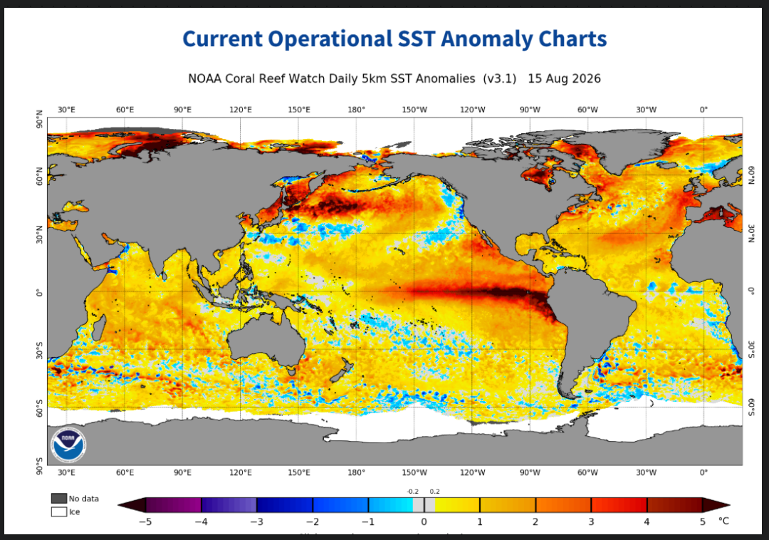
Stone Cold Stunner of a day. Finally out in balcony relaxing.









.png.6d88b21c8fae424f45adcbb54f1680c6.png)