All Activity
- Past hour
-

Pittsburgh/Western PA WINTER ‘25/‘26
colonel717 replied to Burghblizz's topic in Upstate New York/Pennsylvania
NWS Pgh discussion Starting to hear alot of chatter about snow this weekend? Lets break down the forecast and discuss some potential outcomes, and have a moment to talk about forecast uncertainty: We like to think about the forecast as a train heading into the rail yard. You start on one track. As you go through time, that one track turns into two, then perhaps four, and eventually, you could end up with tens on potential tracks the train could take as it arrives. Lets think of these tracks as potential scenarios for the weather. You start off the forecast process right now on one track (there is really only one scenario for what's happening right now). Out a couple days, there may be a couple scenarios for what weather might happen. If you go out as far as 5-7 days, the forecast has a good deal of uncertainty with many potential scenarios. Ironically, much of the uncertainty in the weekend storm (most likely to happen between Saturday night and Monday) will come down to "tracks" (not the railroad ones). For simplicity, well break the storm potential down into three scenarios... Scenario #1: The storm track stays well to the south and the area ends up with very little to no snow. This would produce <1" of snow accumulations, if any. This scenario is around 20% likely at this point given current weather prediction guidance. While mostly dry, scenario would be the coldest (temperatures 20-30F below average). Scenario #2: The storm track forms to the south and then curves north as it heads towards the mid-Atlantic region. In this scenario, the region would see snow, but not the worst of the storm. This storm track would produce notable accumulations (likely >1" but <6"). This scenario is around 50% likely at this point given current weather prediction guidance. Scenario #3: The storm track forms to the south then curves up the spine of the Appalachians before reforming off the coast. In this scenario, the region would see the heaviest snow from the storm. This track would produce heavy accumulations (likely >6" to as much as 12"). But this scenario is 30% at this time given current weather prediction guidance. Given the current forecast, here's what we know right now: eastern Ohio and northwest PA have the lowest probability of warning criteria snow (>6"), while the ridges of PA/WV have the highest probability of warning criteria snow). Remember, staying in tune with the forecast will be important, because as we draw closer, we will know more information and gather forecast confidence as we narrow down the amount of potential "tracks" and iron out more specific details of snow amounts and impacts. -

January 2026 regional war/obs/disco thread
tamarack replied to Baroclinic Zone's topic in New England
Or cornmeal. Jan 27-28, 2015 dumped 20" at our place, all at single-digit temps, and with 2.17" LE - a nice 9:1 ratio. Stuff was nasty to walk thru, like deep soft sand. -
Sleet bombs can be fun. Especially with an arctic outbreak following it. Literal glacier situation.
-

Possible Record Breaking Cold + Snow 1/25 - 1/26
NEG NAO replied to TriPol's topic in New York City Metro
It wasn't JB and I should have mentioned they only said it was a possibility not definite - I think 15:1 is reasonable considering this air mass coming in from the north is quite unusually cold for this area during a snow event. -
Yeah in general that’s it. Technically in this scenario they are actually both slowing down and phasing later timing wise, but further west nonetheless. I think if we are going to have a phase, a quicker one is the better of the two evils cause at least the TPV and HP won’t be retreating by then.
-
Good catch that was meant to be a 20 (2/12/2012) I will update
-
Yes we greatly appreciate you being here Michelle. Thank you.
-
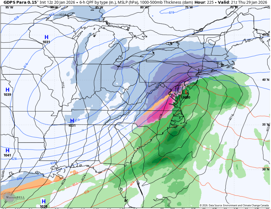
GDPS Para smokes the entire 95 corridor. Pretty much best case scenario. Probably 16-18” using 10-12:1 Edit - NINJAd. Kuchera map is insane. Cut it by 1/4 at least
-
I could see this being one of those where the local mets go 4-8. Then up it to 6-10. Then up it again to 10-14. I used to love watching Bob Ryan constantly upping the totals. Always made me chuckle. He was the original DC snow weenie.
-

Possible Record Breaking Cold + Snow 1/25 - 1/26
North and West replied to TriPol's topic in New York City Metro
. -

Possible Record Breaking Cold + Snow 1/25 - 1/26
SnowGoose69 replied to TriPol's topic in New York City Metro
20:1 is tough here outside of maybe a clipper in a very cold setup. Coastal lows usually its either too warm or too windy for ratios that good. PD2 is a case though where I think ratios may have been close to that and 2016 -
I really hope that does not pan out for the SE. That could be devestation.
-

Possible Record Breaking Cold + Snow 1/25 - 1/26
MANDA replied to TriPol's topic in New York City Metro
No way in hell at this point to determine where best snow growth will be, banding and lift etc. We're still trying to figure out the synoptic situation much less pull apart soundings 120 hours out. Surface temperatures alone do not determine ratios. A gusty wind can reduce ratios. Not to mention how much against climo 20:1 would be for the metro. JB is a great one for pushing 20:1 / 30:1 ratios and I can't think of ONCE when he was right on that during a moderate or major storm. -
Having done forecasts there for years the wedge often times tends to be deeper in NE Ga so they end up more sleety in this storms. I think if this trends more to FZRA they'd probably see much less precip and just get like 0.25 FZRA and that is all. There is a narrow setup for them to see monster ice totals there. The wedge tends to save them or the system just usually cuts more north and they are drier.
-
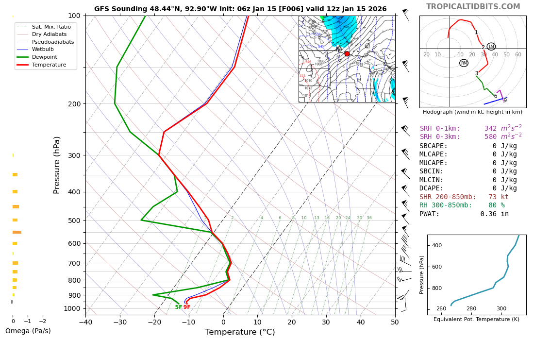
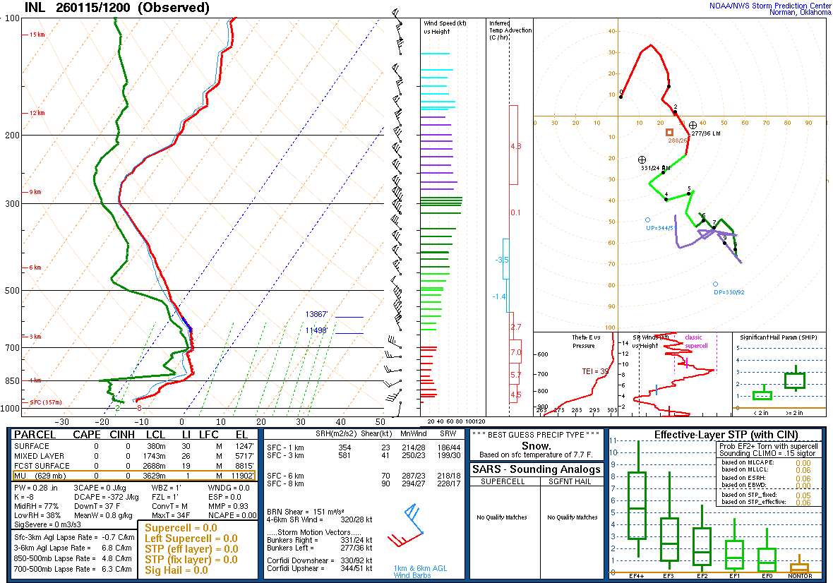
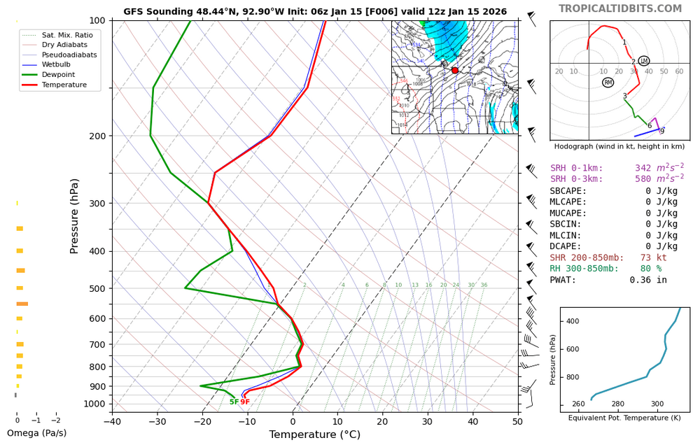
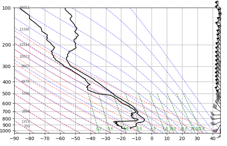
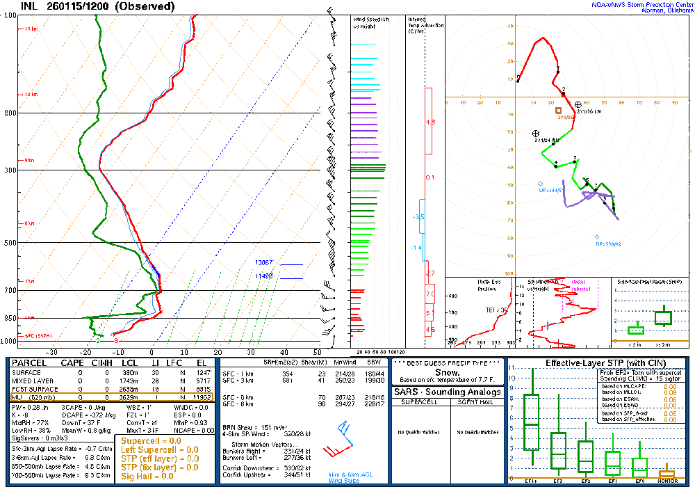
Found NOAA's sounding page. Notice the difference in temps from what was on the Wyoming site. Strange. Yet this mornings sounding looks good. https://www.spc.noaa.gov/exper/soundings/
-
Crippling ice storm. Gas stations will be closed for days as well. Trees and power lines down. Hard pass.
-
The 2 in Feb 2012 has to be a mistake. I don't ever remember it getting anywhere near that cold at any point during that winter.
-
Damn.
-
No power Flo
-

2025-2026 Fall/Winter Mountain Thread
buckeyefan1 replied to Buckethead's topic in Southeastern States
Thank you Steve, I appreciate you I’ll admit it’s really tough without him. We made the best team -
Even 1/4-1/2 of those totals is disastrous.
-
-

January 2026 regional war/obs/disco thread
CCHurricane replied to Baroclinic Zone's topic in New England
Ah, understood -
Yes, this should be interesting!
-

January 2026 regional war/obs/disco thread
vortex95 replied to Baroclinic Zone's topic in New England
And it was quick hitter in much of MA/RI. I got about 15" in 8 hr in Woburn Snow began not long after midnight and it was clearing out by 9am!