All Activity
- Past hour
-
.thumb.jpg.ad3a2e31d30aff035044689b311a0540.jpg)
1/24-1/25 Major Winter Storm - S. IL, IN, MI and OH
nvck replied to A-L-E-K's topic in Lakes/Ohio Valley
nice, am from the eastern suburbs but going to school in Michigan. will be content to watch this one from the sidelines and hope to get 1-2" up here from it. -

Pittsburgh/Western PA WINTER ‘25/‘26
southpark replied to Burghblizz's topic in Upstate New York/Pennsylvania
They decreased totals a little. Still looking good though. -

Richmond Metro/Hampton Roads Area Discussion
overcautionisbad replied to RIC Airport's topic in Mid Atlantic
I wouldn't be so sure of that. 12Z Euro has 4.7 inches in Richmond right before changeover. It’s trending back up. Other models have higher on 12z. So, we'll see. On to 18z and 0z -

January 25-26 Winter Storm Potential
CoolHandMike replied to Ralph Wiggum's topic in Philadelphia Region
Winter '94? I was also on main campus. I remember cars being completely buried and a massive snowball fight in between the dorms. I caught a stray to the side of my head that blew out both of my glasses lenses (we somehow found them in the snow anyway) and then we got in trouble for climbing on top of one of the covered walkways. Good times. -

January 25/26 Jimbo Back Surgery Storm
Brick Tamland replied to Jimbo!'s topic in Southeastern States
-
My husband told me to, and I quote, "Quit looking. No one knows.". Then he sighs, rolls his eyes, tells me to quit looking at the hype, and then goes back to watching TV.
-
Onset is close enough to use the Meso's for thermals at the start of the storm. I am curious if some of us can start in the single digits at the surface.
-
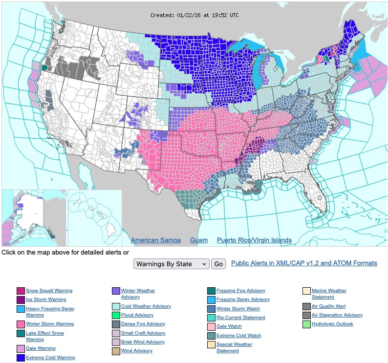
You don't see a map like this every Winter.
-

January 2026 regional war/obs/disco thread
Prismshine Productions replied to Baroclinic Zone's topic in New England
1.5" last night, tenth off the squall... 26" ots with the pattern coming up I *might* hit seasonal (56.5") by April (I hope). Seasonal totals since moving up here: 2023-24: 38" (42.5" total, 4.5" storm before moving up here) 2024-25: 60.1" 2025-26: 26" to date Sent from my SM-S166V using Tapatalk -

January 24-26: Miracle or Mirage JV/Banter Thread!
mattie g replied to SnowenOutThere's topic in Mid Atlantic
I love when people question why someone might be disappointed in a flip. It's really thoughtful and no doubt makes the person on the other end automatically feel better about the prospect of flipping to sleet. -
I'm going to put this here although it could easily go in this weekends storm thread 60-72 hrs lead issuing WSW region wide???? For a decent duration six inch plus event?? Maybe for the folks mid Atlantic and into the TN valley and OHIO valley and south....esp in regards to icing Still 2 full days for changes..it does sound miserably cold regardless Have we not learned anything from early March 2001?
-

MO/KS/AR/OK 2025-2026 Winter Discussion
JoMo replied to stormdragonwx's topic in Central/Western States
1:32 PM Official forecast hazardous outlook graphic shows 7-14" with areas of 8-15" in nearly every part of SGF's territory. Now time for the 18z NAM to screw it up somehow. -
South trend!
-

January 2026 regional war/obs/disco thread
powderfreak replied to Baroclinic Zone's topic in New England
True whiteout conditions. Just had thunder and lightning at the mountain. 2.5” in 30 minutes. That was a legit squall. -

1/23/26-1/25/26 Winter Storm Thread
Holston_River_Rambler replied to AMZ8990's topic in Tennessee Valley
I am very glad I don't live in one of the freezing rain CAD areas of GA or the Carolinas for this one. -

Possible Record Breaking Cold + Snow Sunday 1/25 - Tuesday 1/27
wthrmn654 replied to TriPol's topic in New York City Metro
Everyone's getting old, there turning back into children-like-adults -

Possible Record Breaking Cold + Snow Sunday 1/25 - Tuesday 1/27
Snowfreak09 replied to TriPol's topic in New York City Metro
haha no-- long time lurker for over 10 years- post occasionally... enjoy the regulars- but these snowflake newbies out of control lol -
I am not saying for better or worse... but the on the H5 map in the west things are moving around by 50 miles or so... just have the 6 hour mark
-
NAM is running. Stronger confluence early (hr12) but have to see if it sticks around long enough.
-
 This whole thread morphed into bizzaro world a few days ago when they talked themselves into a changeover that will not occur for 90% of the region if it occurs at all. Frankly, in all my years here, Ive never seen anything like it All you can say is there is 1-1.5 inches of precip headed this way with legit arctic air locked in. What falls is going to stick it’s gonna stick fast and it’s gonna stick ugly.
 -
January 2026 regional war/obs/disco thread
Prismshine Productions replied to Baroclinic Zone's topic in New England
Snagged a tenth, it already melted (rates were high enough that it stuck above freezing) really wet paster Sent from my SM-S166V using Tapatalk -
https://x.com/gmengel/status/2014425234389033133?s=46&t=sfs6kta7ijyVFPbzpqZcJg .
-

Richmond Metro/Hampton Roads Area Discussion
Deep Creek replied to RIC Airport's topic in Mid Atlantic
Wakefield’s map is probably more realistic, although I still think it’s overdone for metro Richmond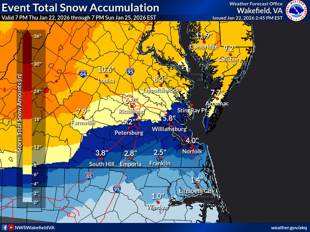
-

MO/KS/AR/OK 2025-2026 Winter Discussion
The Ole Bucket replied to stormdragonwx's topic in Central/Western States
NWS STL finally getting fully onboard.. -