All Activity
- Past hour
-
I fully agree in the short term. When we cross the 2c threshold and the negative consequences become so glaringly obvious there will be across the board support for change. When sea level rises another 3 feet you start inundating extremely valuable coastal land. When summer temps are so high in the worlds bread baskets that cereal crops can no longer grow. That’s when the general populace has to wake up. When the destruction of wealth leds the charge. Capitalism is highly flawed in regards to long term greater good tendency. As we currently have the knowledge and tech to prevent most of this from happening.
-
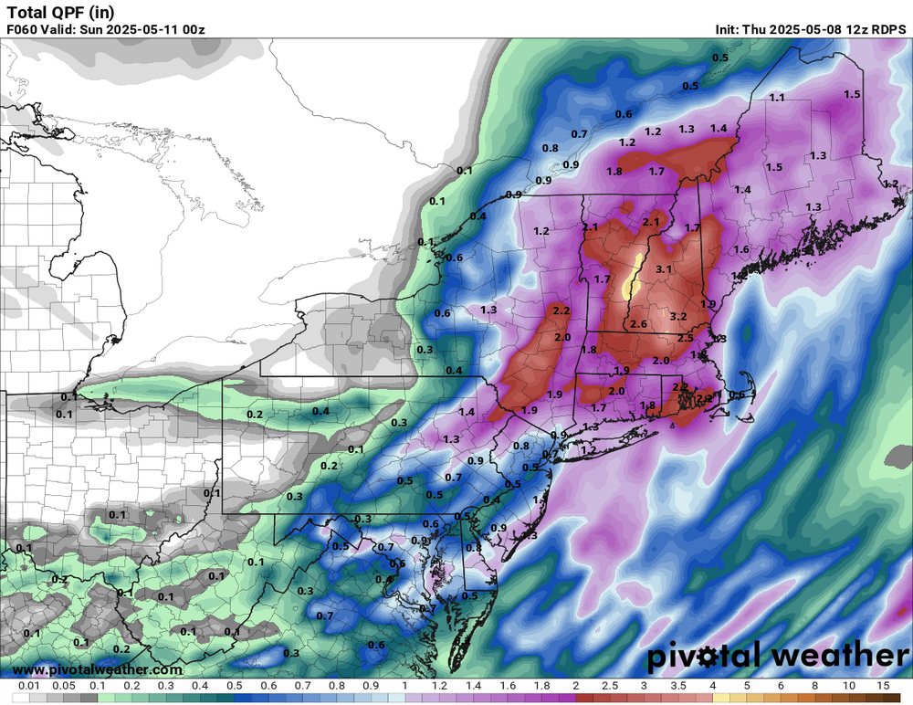
Probably a half to 3/4" with more east west and north
-

2025 Spring/Summer Mountain Thread
Tony Sisk replied to Maggie Valley Steve's topic in Southeastern States
I really don't understand the image. So, most of the Upstate and all of Western NC are colored yellow, meaning "Slight" Risk. Yet, the description says that the circled area "WILL SEE" especially large hail. Wouldn't that mean that they are under a High Risk? Or maybe it mean all of the area is under a slight risk for hail, but if it does hail in the circled area, it will be large hail. See why I'm confused? -
Still in D1 even after the 2"+ of precipitation from the latest system. Supposedly due to low stream flow and ground moisture. Not the case in my area. There is a stream (Furnace Brook) that runs through my property and it is anything but low. More like roaring or raging.
-
@Damage In Tolland
-
We have seen a nice improvement since last fall as it’s tough to keep a really dry pattern going in this much wetter climate.

-
Sorry, this is most likely not the right place for this question... but what is stein? Thanks
-
Why does it have to rain everywhere but where people actually live? Lolol
-

2025 Spring/Summer Mountain Thread
Maggie Valley Steve replied to Maggie Valley Steve's topic in Southeastern States
Having a 15% Hatched for large hail is nothing to sneeze at for our Mountain folks. I'll be watching to see how things unfold for our neighbors in Eastern Tennessee in the afternoon. It's a good day to keep an eye on the weather.
-
Summer stunner in Watertown, car thermo @83!
-
Local action without a major outbreak is tough to do in East Tennessee. These are really the best days! Work isn't nuts, but we still got a shot at seeing a good shelfie or random ping pong ball. Oh I should be careful about what I wish. China had giant hail yesterday. We don't need that! Golfball is the red line where it goes from neat stuff to big trouble. We also have a 2% tornado which feels broad. I'd focus that right on the east-west boundary that will sharpen up by late afternoon. It's forecast along or just south of I-40. If it can stay up there, the Upper Cumberland Plateau has a history of modest tornadoes beneath otherwise meh upper-level shear. I believe being elevated promotes a stronger surface wind; then add a boundary, and it's just enough low level shear. Elsewhere I feel like shear is just not quite there. Upper levels are modest. Low levels get a little veered south of I-40. We'll see.
-
It'll bust...3K nam is much faster and over by late afternoon
-
I’m fine with getting the rain now since we often dry out so much in the summer. Build up the groundwater now and have it as a buffer when almost inevitably on LI we can go weeks without appreciable rain from June-Sept.
-
NOAA ends extreme weather database that has tracked cost of disasters since 1980 https://www.cnn.com/2025/05/08/climate/noaa-ends-disaster-database
-
12z mesos look great for Frederick county!
- Today
-
To this day, summer 1988 holds the record for the most 90F+ days on record at Detroit (39). With a widespread drought going on, I assume the humidity was unusually low. I was only 5 but Ill never forget seeing a grass fire ignite before my eyes. There was indeed a brief but potent (for the season) cold snap to start July. In fact, DTW had a record low of 48F on July 1st, sandwiched between a sea of record highs in June & July. That summer saw 5 days of 100F+, which is 2nd only to 1936 with 8. Nevertheless, its an absolute joke to take an alleged 32F reading at a random coop station with a very possibly faulty thermometer in an extremely rural area, in one of the last months that station kept records....and just say "hey it was 32 this day, youd never see that today". BTW the official low at Pittsburgh that day was 49F. Lmao do you know some of the insane readings that come from some of the cold spots in rural Michigan during the summer?
-
Thanks. Andy H said: “If this forecast is accurate, we could see the 3 big NH basins (West Pacific, East Pacific, Atlantic) all struggle to produce TCs this year.” You never know as he may be into something. But based on the Euro and other things and the fact that no El Niño is forecasted, this sounds quite a bit overdone for the Atlantic basin. The ATL could imho easily have a NN season as the Euro predicts. But having a quiet season there seems unlikely to me. And I’m saying this being someone near the coast who would love nothing better than the lowered stress of a quiet season with last year being particularly bad. The SE US is overdue for a low stress season. But I don’t forecast based on my desires/wishcast.
-
Top 5 warmth across the area for the 1st week of May. EWR…5th warmest LGA….5th HPN….5th JFK….5th ISP…..4th BDR….5th PHI…..5th
-
once again the euro is the furthest sw and the wettest
-
@WxWatcher007 would not be pleased https://x.com/AndyHazelton/status/1920133584146354231
-

Central PA Spring 2025
Mount Joy Snowman replied to canderson's topic in Upstate New York/Pennsylvania
Low of 52. Need to sneak a mow in somehow today. -
Through the first week Temp Dep: NYC: +4.8 LGA: +5.4 JFK: +5.5 TTN: +6.9 EWR: +6.9
-
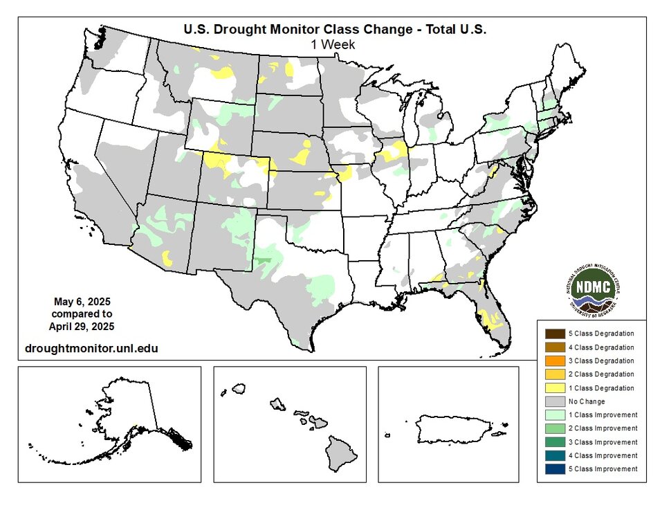
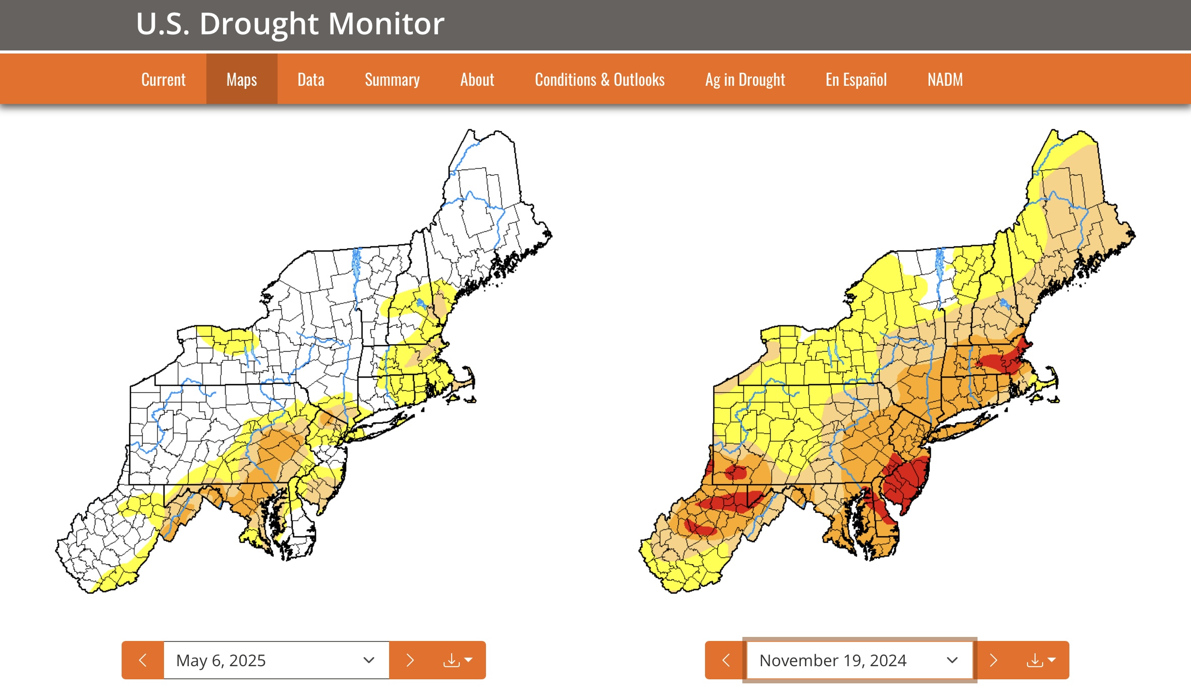
I remain skeptical of calls for a wetter pattern. While I agree that there are things that may point to it, often times we see much of the precipitation off to the north and west or hook around and out of the area entirely. This has been a trend for month after month now. The latest drought monitor is out, which shows modest improvements in the more severe drought areas for NJ, but much of the more pronounced improvements in the northeast are all over central PA as well as central and western NY State.
-
Nice ... 67 and the sky is allowing a flood of sun in. Nice little sneaky gem day in between the shits.
-
Unfortunately, the Pacific Jet has been too strong during the winter. So as the gradient weakens further into the spring, the weaker jet isn’t able to act as a kicker. So these closed lows get stuck in place when people are ready for sunny spring weather. But the good news is that the northern edge of the drought areas to the north of I-80 and into CT has improved with the soaking rains there in recent days.