All Activity
- Past hour
-

First Winter Storm to kickoff 2025-26 Winter season
TauntonBlizzard2013 replied to Baroclinic Zone's topic in New England
The 18z gfs might be over more amped than 12z -

First Winter Storm to kickoff 2025-26 Winter season
weatherwiz replied to Baroclinic Zone's topic in New England
Looks like 18z gfs going to be quite amped...shocker. -

Nov 28-30th Post Turkey Day Winter Storm
SchaumburgStormer replied to Chicago Storm's topic in Lakes/Ohio Valley
Guys. This is our moment. After half a decade of hell, we might have something trending our way. -
18z gfs deciding to take the low into wv and warm af. It’s on its own island right now.
-

Central PA Fall Discussions and Obs
Ruin replied to ChescoWx's topic in Upstate New York/Pennsylvania
YOU ALL WILL BE HAPPY ITS GOING TO SNOW A FOOT FOR HARRISBURG BOOK IT -

First Winter Storm to kickoff 2025-26 Winter season
dryslot replied to Baroclinic Zone's topic in New England
No, lol, That's where PF likes it, We want it to track inside the BM. -

November 2025 general discussions and probable topic derailings ...
ineedsnow replied to Typhoon Tip's topic in New England
Snowing insanely hard now... wooo.hooo -
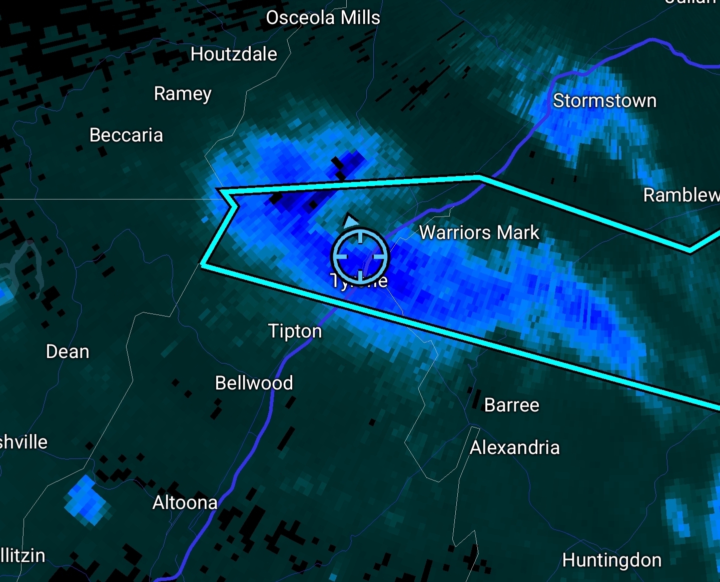
Crazy snow squall up here in Tyrone, PA. Quick quarter to half inch.

-

First Winter Storm to kickoff 2025-26 Winter season
DavisStraight replied to Baroclinic Zone's topic in New England
Is that the track we want in Maine? Looks like we get brushed with a ok amount on the models. -

December 2025 regional war/obs/disco thread
Damage In Tolland replied to Torch Tiger's topic in New England
Sexual Healing? -

December 2025 Short/Medium Range Forecast Thread
Carvers Gap replied to John1122's topic in Tennessee Valley
This kind of feels like one of these patterns where the warm pattern sits at about d13-15 and holds for a while. Models really want to rush through the cold phases of the MJO, and that often ends up being an error. It really looks like it wants to take its time. Modeling was about 7-10 days too fast w/ the cold snap, and likely will be similar when we flip back warm. I mean at some point during a La Nina winter, that trough has to slide into the Mountain West, right? OTH, there is some brainstorming that this pattern is starting to show some Nino tendencies. We do NOT want a La Nada in E TN. Weak ENSO(Nada or Nino) is preferred. The Euro Weeklies look good for most of December. They do show the trough eventually backing West, but that likely happens due to normal pattern cycles as well. Here is the kicker...if that SSW finally works its way into the TPV, that warmup might not be real. There is a risk of a double dip cold snap. Nina climatology(cold December) + early season SSW (cold early and/or mid Jan) is on the table. I do not think modeling even remotely has this pattern modeled well. The -NAO on the 12z suites was prominent. If that deal is real, things could get really squirrelly. I will be really surprised if we don't have something to track very soon. -

First Winter Storm to kickoff 2025-26 Winter season
moneypitmike replied to Baroclinic Zone's topic in New England
Since a thread was started, I'll be disappointed if the snowblower isn't needed -

First Winter Storm to kickoff 2025-26 Winter season
Lava Rock replied to Baroclinic Zone's topic in New England
Honestly, would be happy with 1-3" to whiten it up, but not getting invested in storms till xmas time Sent from my SM-S921U using Tapatalk -
First Winter Storm to kickoff 2025-26 Winter season
TauntonBlizzard2013 replied to Baroclinic Zone's topic in New England
Looks good from my house -
First Winter Storm to kickoff 2025-26 Winter season
dryslot replied to Baroclinic Zone's topic in New England
Tracking over PWM. -

2025-2026 Fall/Winter Mountain Thread
Maggie Valley Steve replied to Buckethead's topic in Southeastern States
The Friday afternoon update from the Climate Prediction Center suggests we stay cold and wet until the 26th of December. It's been a while since I've seen them this bullish on cold and wet for an extended period during the winter. -

First Winter Storm to kickoff 2025-26 Winter season
powderfreak replied to Baroclinic Zone's topic in New England
Ha it was in jest as a joke. Personally, I want it over like metro-west of BOS, lol. I feel like it’s my duty as a white walker north of the wall for a comment here and there… but in reality it is nice to see enthusiasm and hope again on the forum. It feels a bit like the old days on here for the past 48 hours or so. -

December 2025 regional war/obs/disco thread
40/70 Benchmark replied to Torch Tiger's topic in New England
Had the ground whitened here....nice mood setter. -
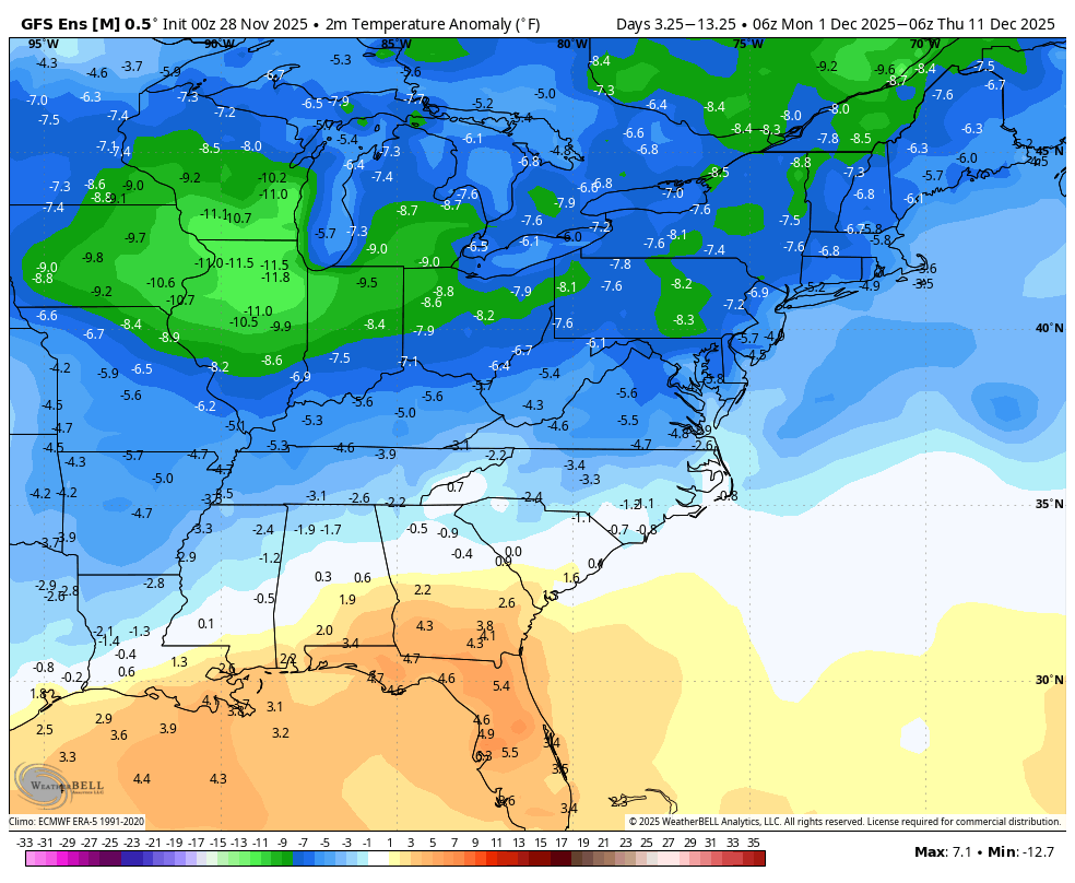
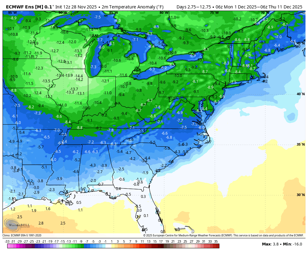
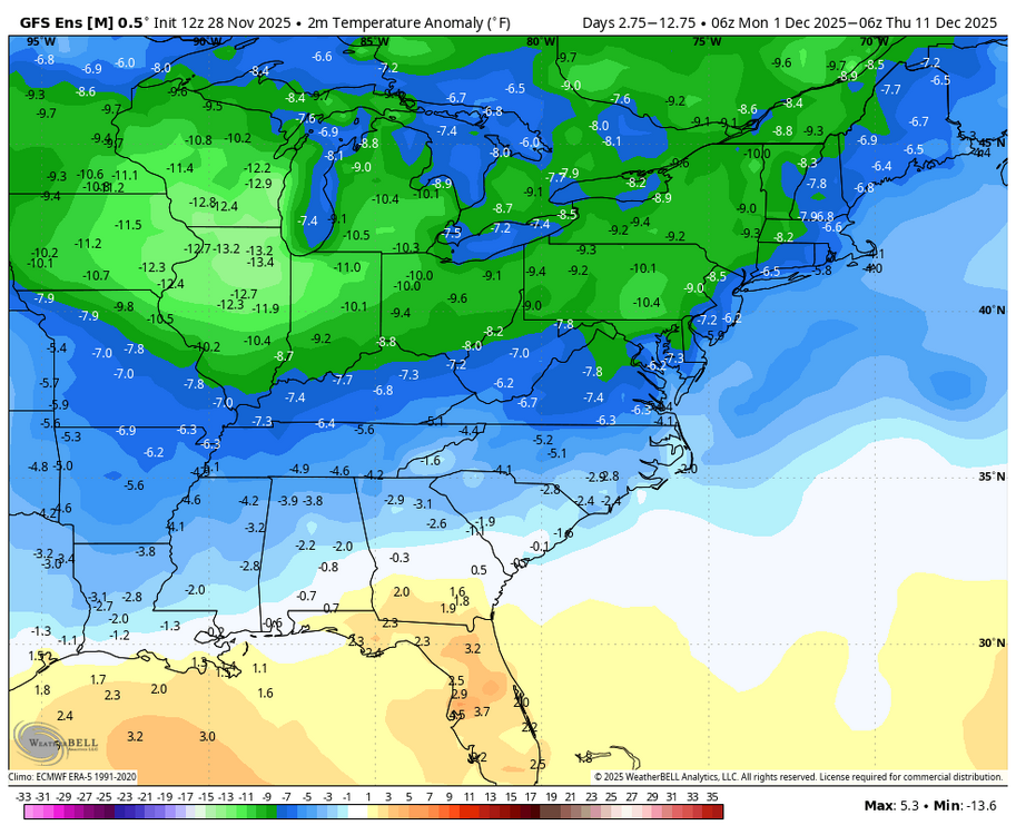
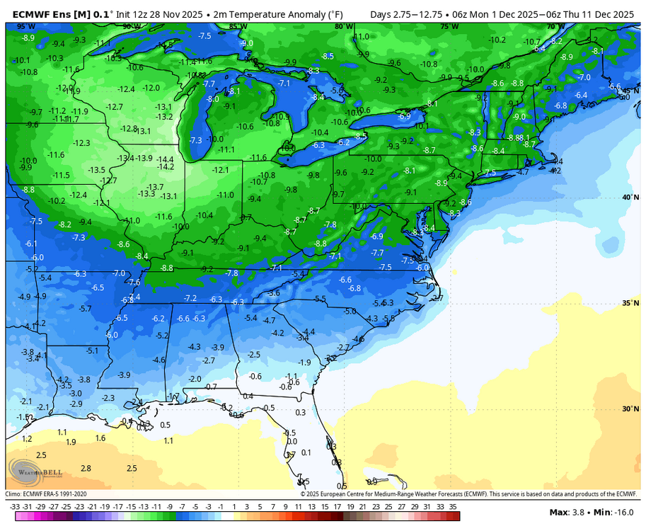
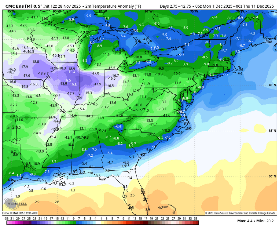
For Dec 1-10: 12Z EPS held onto its 0Z significantly colder temps vs 0Z GEFS. But also, 12Z GEFS came in significantly colder than 0Z GEFS: 0Z GEFS: 12Z GEFS: colder/in EPS direction: 12Z GEPS came in much colder than 0Z GEPS: 0Z GEPS: 12Z GEPS: colder than 0Z GEPS

-
November 2025 general discussions and probable topic derailings ...
powderfreak replied to Typhoon Tip's topic in New England
That’s one helluva band right through ALB airport area.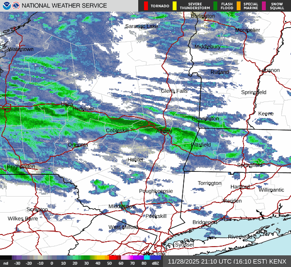
-

Nov 28-30th Post Turkey Day Winter Storm
Chicago Storm replied to Chicago Storm's topic in Lakes/Ohio Valley
this whole thing is essentially waa. -
Kraft or die.
-
Icon getting interesting for the coast
-

Nov 28-30th Post Turkey Day Winter Storm
A-L-E-K replied to Chicago Storm's topic in Lakes/Ohio Valley
Radar looks good, early weenie waa will make or break -
Hopefully