All Activity
- Past hour
-
November is on track to finish with a mean temperature of 58.4° in New York City. That is 0.5° above normal and 1.5° above the earlier 1981-2010 baseline. Highs will reach the middle 50s in much of the region tomorrow and Sunday. Lows will mainly be in the lower and middle 40s in New York City and 30s outside the City. In the long-range, the guidance suggests that an AO+/NAO+ regime could develop the first week in November. As has often happened with the loss of strong blocking, a milder regime could develop late in the first week of November or shortly afterward. The ENSO Region 1+2 anomaly was +0.3°C and the Region 3.4 anomaly was -0.6°C for the week centered around October 22. For the past six weeks, the ENSO Region 1+2 anomaly has averaged -0.07°C and the ENSO Region 3.4 anomaly has averaged -0.48°C. La Niña conditions will likely continue through mid-winter. The SOI was +11.28 today. The preliminary Arctic Oscillation (AO) was -1.064 today. The NAO was -1.321.
-

Major Hurricane Melissa - 892mb - 185mph Jamaica landfall
WolfStock1 replied to GaWx's topic in Tropical Headquarters
Unfortunately the end toll will probably come in that high. It's early. Saving grace is they had lots of warning. However unlike the US most people just don't have the ability to evacuate, at least in terms of going somewhere hundreds of miles away in another state that's safe. -

Spooky Season (October Disco Thread)
Damage In Tolland replied to Prismshine Productions's topic in New England
-
We are in October, not December. Saying should be the kiss of death for us is a weenie statement.
-
Now that Melissa is gone I’ve moved from tropical to late fall mode. With one of my locations now being SLK I’d love to post here too representing the western portion of the BTV NWS area, if y’all will have me.
-

2025-2026 ENSO
TheClimateChanger replied to 40/70 Benchmark's topic in Weather Forecasting and Discussion
-
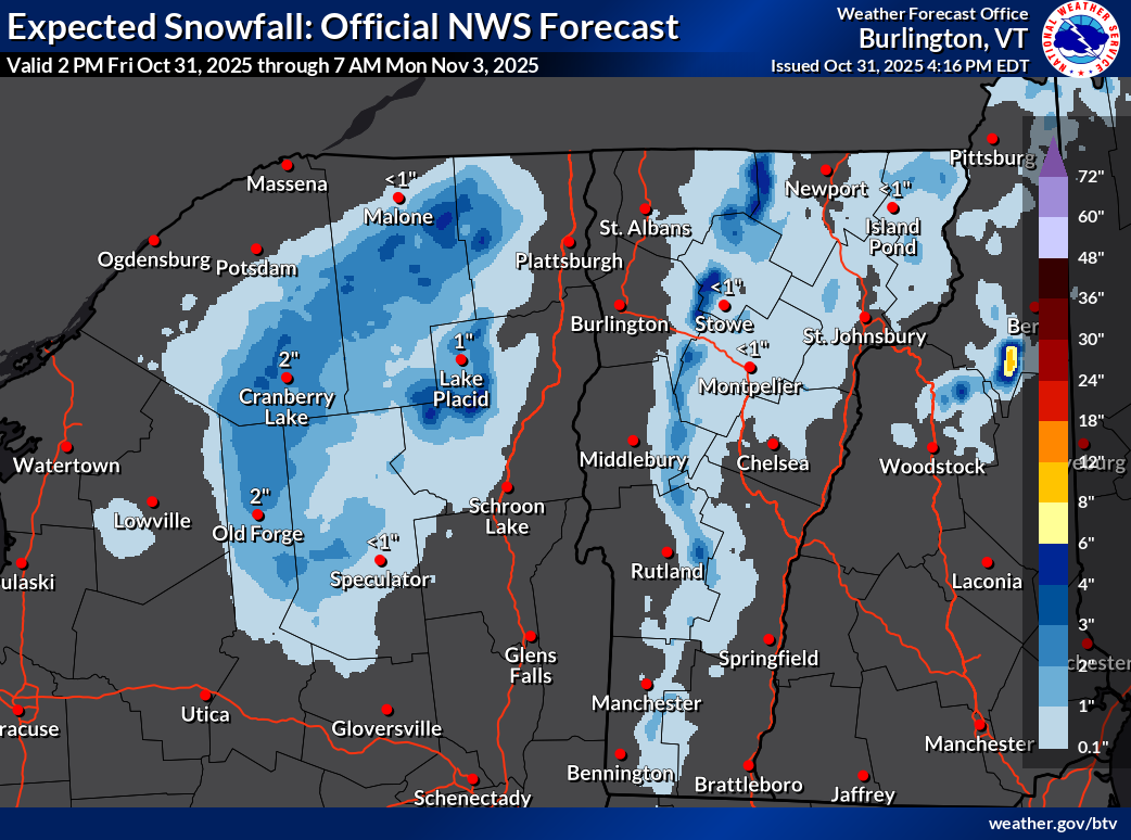
Snow is back in the forecast for the Green Mountain spine, and the BTV AFD is asking the questions we are all thinking... it appears as though cold season is nearly upon us! Looking forward to the incoming stake photos tomorrow morning, may this winter be as cold as the last! .SYNOPSIS... Cool and blustery conditions will prevail for most of this upcoming weekend with occasional valley rain and mountain snow showers. A light slushy snow accumulation is possible above 1500 feet by Saturday morning, as temperatures fall into the upper 20s to near 40. Westerly winds will gust at 30 to 45 mph at times overnight, before slowly weakening on Saturday. Warmer and drier weather returns by early next week, as temperatures climb back into the 50s. && .NEAR TERM /THROUGH SATURDAY/... As of 247 PM EDT Friday...Updated to remove equipment section as TYX radar is back in service. A cool, blustery and showery evening is on tap for Halloween activities. Sfc analysis places an impressive 978mb low pres just east of Sherbrooke with deep/vertically stacked system slowly moving northeast. Storm total rainfall has been 1.72" here at BTV thru 2:45 PM, just imagine if it were colder. This closed cyclonic circulation wl produce a prolonged upslope precip event acrs our mtns thru at least Sat morning, before drier air develops by Sat aftn and precip slowly dissipates. The highest pops near 100% and greatest qpf wl be focused over the northern Dacks and central-northern Greens, with much less in favorable downslope areas of the CT River Valley and parts of the western CPV. Whiteface summit temp already down to 30F with flakes flying and little Whiteface at 3000 feet is 33F, would expect snow level near SLK/Lake Placid by 00z, as progged 925mb temps fall below 0C. For the Green, snow levels start near summit level this aftn, but falls to 3000 feet by 00z and near 1500 feet around midnight. 925mb temps hover btwn -1C and -3C, so a slushy snow accumulation is possible on grassy surfaces down to 1500 feet or so by morning. Expecting 1 to 3 inches btwn 1800 and 3000 feet, 2 to 4 inches between 3000 and 4000 feet and 4 to 6 inches at summit level of both the Greens and Dacks by Sat aftn. Will there be enough for the rock skis and boards by midday Saturday?

-
 Mine did that as well. Cocorahs gauge was 1.86 and ambient was 2.08. Like Walt said, intense rains sometimes skew it high. I've had the 2902 for 5 years now
 -
.thumb.jpg.6a4895b2a43f87359e4e7d04a6fa0d14.jpg)
Central PA Fall Discussions and Obs
Yardstickgozinya replied to ChescoWx's topic in Upstate New York/Pennsylvania
My youtube feed has been full of talks of early winter snowstorms , visitors from outer space and AI pandas. It looks like it's going to be one hell of a digital ride this winter, hopefully we can have some early season sleigh rides to match. -

Central PA Fall Discussions and Obs
canderson replied to ChescoWx's topic in Upstate New York/Pennsylvania
We should switch houses! -

Central PA Fall Discussions and Obs
Voyager replied to ChescoWx's topic in Upstate New York/Pennsylvania
Lol... haven't even cracked 13 in my backyard. But if you've ever been to or through Tamaqua you'd see how protected we are by nearby mountains. Even in Sandy, while all hell was breaking loose in the more open townships, we were "relatively calm" here. I could hear the roar of the trees on the mountain tops surrounding the town, but it really was a near non event in town itself. We were one of the few areas that didn't lose power at some point during that storm. -

E PA/NJ/DE Autumn 2025 Obs/Discussion
Albedoman replied to PhiEaglesfan712's topic in Philadelphia Region
noon runs look like an overunning situation possibly forming after a cold frontal passage near 11/13 with cold enuf temps to have frozen precip. Something to watch. The cold frontal passage on the 10th will bring hard freezes with temps in low 20's and high in the upper 30's. -
Could tonight be the night? The wind has really died down here and it’s 59°.
- Today
-
 Quite gusty here. Definitely 40 to 45 range but probably not higher
 -
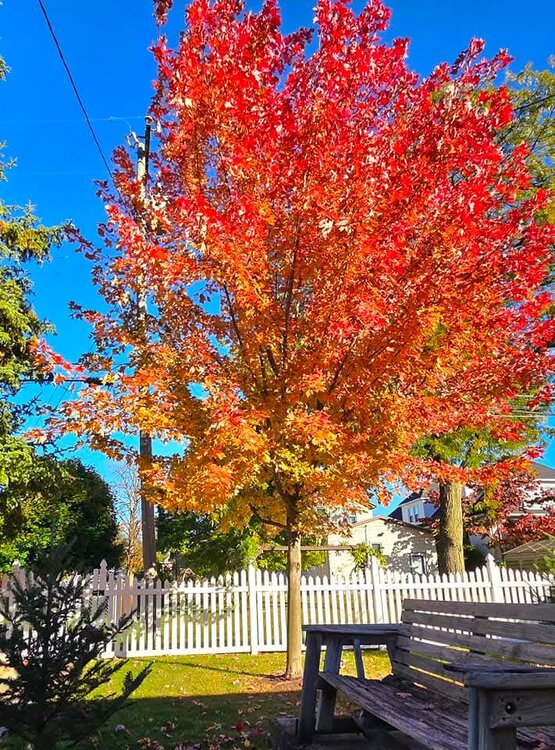
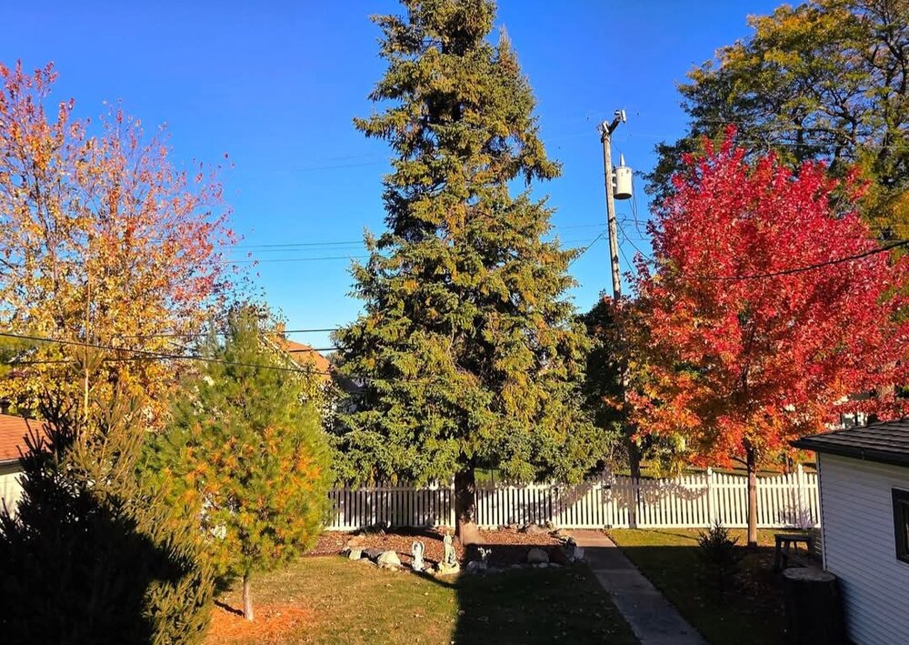
Absolutely love my autumn blaze maple! Its a fast grower and each year the color is more impressive. Primary red but orange and yellow at bottom. Leaves dropping now, but took these pics Oct 28.
-

November 2025 general discussions and probable topic derailings ...
Torch Tiger replied to Typhoon Tip's topic in New England
I am all for folks posting LR model stuff, even an 18z gfs wonked out 360hr. solution. knowing it is not to be taken seriously.? -
November 2025 general discussions and probable topic derailings ...
Torch Tiger replied to Typhoon Tip's topic in New England
AI is weird at that range. Lets at least use ensemble ? lol -
Spooky Season (October Disco Thread)
Damage In Tolland replied to Prismshine Productions's topic in New England
Starting to get some good rips now -
 Intensity skews the Ambient too high... Light rain usually very close but when it gets intense, the automated gage runs too high. At least it rained
- 245 replies
-
- 1
-

-
- heavy rain
- damaging wind? squalls?
- (and 2 more)
-
Yes criteria gusts at many of the ASOS's 40-43 kt as of 3PM ish. Conversion factors on the 06z models except ECMWF were too weak. Multi NWS office Wind Advisory verifies! Power outages today, almost twice that of yesterday-see below. We've had a brief outage in Wantage NJ. Most of the branches I've seen down in Sussex County from Wantage, Andover-Hopatcong are the 1-2" dead ones but one larger in Hopatcong was being removed around 130PM. Outages by StateOutages by Utility New Jersey20,356 New York18,472 Pennsylvania17,100
-

Spooky Season (October Disco Thread)
DavisStraight replied to Prismshine Productions's topic in New England
Looks like some snow in the batch looking at myradar. -
 EWR, JFK, and LGA all gusting to 45 mph now. Decent winds here but nothing particularly noteworthy.
 -
Spooky Season (October Disco Thread)
DavisStraight replied to Prismshine Productions's topic in New England
Ever hear od Osage Orange? I think that's the hardest wood in the US, for something harder you'd have to go to Africa. -
Central PA Fall Discussions and Obs
canderson replied to ChescoWx's topic in Upstate New York/Pennsylvania
Big winds - 45 mph the last 10 mins -
Absolutely gorgeous day here for the last day of October. Low of 46, high of 68. Dew points in the mid 40's. Monthly stats: Highest temp: 86 Lowest temp: 43 Highest dew point: 75 Lowest dew point: 36 Rainfall: 3.31"