All Activity
- Past hour
-
Not for me
-
Last week was Mother Nature cracking up at us.
-
56/32 FEW Not a bad day out there although there’s some rogue good gusts at times.
-
Smoke is visible in this area due to the S GA fires.
-
why? i understand winter is your thing but constant grey 50's with rain and wind is just gross
-
I would live in Thule, Greenland and eat fermented whale blubber all day before I’d live down there.
-
Probably not. This year is probably the polar of 2020. That year, we had an ending weak +ENSO that transitioned into a solid la nina, and a developing -PDO. This year, we have an ending weak -ENSO that looks like it's transitioning to a strong, if not super, el nino, and an ending -PDO/developing +PDO. Plus, 2019-20 was a very warm and virtually snowless winter that turned cold in April into May, while this winter was cold and snowy, that turned warm in March, and flipped to a torch around Daylight Saving Time.
-
63 and bluebird sky. Beautiful day!
-
Ha ha ha that’s all right. I knew I was going to incur the wrath just by bringing it up.
-
Music to my ears
- 804 replies
-
- 1
-

-
- april showers bring may..
- rain
- (and 2 more)
-
Want to switch ?
-
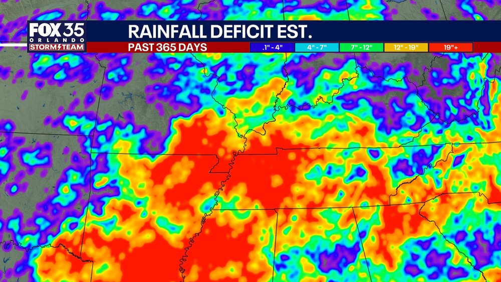
Found this on FB from a local news station in Orlando showing 365 day rainfall deficits. I found it very interesting that the location of the August 2025 flash floods over eastern Hamilton county is very apparent. That was the only significant rainfall in this corner of the state for months.
-
Yep it is bad throughout the Southeast.
-
There are a few ways of looking at this. If you use a linear model, then you would be correct. But a non-linear process involving threshold temperarures of marine heatwaves potentially driving the forcing leading to that record breaking ridge would be a different case. it’s possible in a colder climate the ridge would never have even occurred in the first place since past weak La Ninas had much weaker to nearly non existent ridges in the West. So cooler SSTs absent the record marine heatwaves could have resulted in more of a trough out West rather than the ridge. Since the forcing could have never reached the necessary forcing threshold in a colder climate. So potentially completely different patterns rather than a gradual stepwise change. It’s possible that both your linear hypothesis and the non-linear were both correct and there was an overlap. But it could be challenging to determine exactly how much influence each had. https://agupubs.onlinelibrary.wiley.com/doi/full/10.1029/2022GL101499 Circus Tents, Convective Thresholds, and the Non-Linear Climate Response to Tropical SSTs Using model simulations, we demonstrate that the climate response to localized tropical sea surface temperature (SST) perturbations exhibits numerous non-linearities. Most pronounced is an asymmetry in the response to positive and negative SST perturbations. Additionally, we identify a “magnitude-dependence” of the response on the size of the SST perturbation. We then explain how these non-linearities arise as a robust consequence of convective quasi-equilibrium and weak (but non-zero) temperature gradients in the tropical free-troposphere, which we encapsulate in a “circus tent” model of the tropical atmosphere. These results demonstrate that the climate response to SST perturbations is fundamentally non-linear, and highlight potential deficiencies in work which has assumed linearity in the response.
-
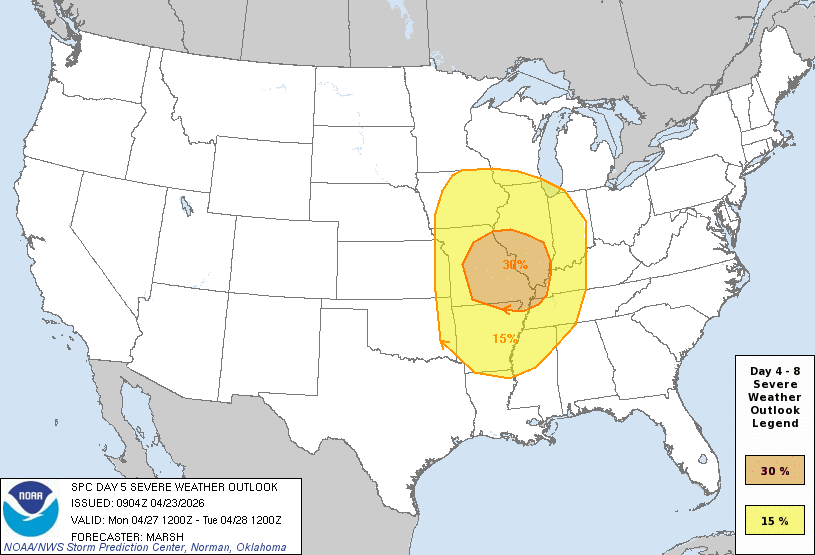
Very large warm sector with much of the western sub highlighted in the 15% for Day 5, Monday 4/27
-
That's why people go to Florida and come back here in May...
-
Well, it was a pretty memorable and spectacular VD Day melt 2007... triggered by the sudden epiphany that that particular snowfall, that night would never live up to expectations due to the inability of the mid levels to cool the .00000001C needed for the sleet to abate. #neverforgetchristine
-
April 23 1990: A record high of 88 degrees is set at Redwood Falls. For Thursday, April 23, 2026 1885 - The city of Denver, CO, was in the midst of a storm which produced 23 inches of snow in 24 hours, and at Idaho Springs CO produced 32 inches of snow. (David Ludlum) 1910 - The temperature at the Civic Center in Los Angeles, CA, hit 100 degrees to establish an April record for the city. (The Weather Channel) 1983 - A mini-blizzard produced sixteen inches of snow at Laramie, WY, including a foot of snow in just eight hours during the night. (The Weather Channel) 1987 - Thunderstorms in the Atlantic Coast Region produced golf ball size hail and wind gusts to 67 mph at Anderson SC. The high winds destroyed two planes at the airport, and the large hail damaged fifty other planes, and severely damaged twenty-three greenhouses. (The National Weather Summary) (Storm Data) 1988 - An intense winter-like storm brought thunderstorms to southern California, and produced snow in some of the higher elevations. Nine girls at Tustin CA were injured when lightning struck the tree under which their softball team had taken shelter from the rain. (The National Weather Summary) (Storm Data) 1989 - Salina, KS, was the hot spot in the nation with a high of 105 degrees. The high of 105 degrees established an April record for the state of Kansas. A total of eighteen cities in the central U.S. reported record high temperatures for the date. (The National Weather Summary) (Storm Data) (The Weather Channel) 1990 - Thunderstorms produced severe weather in West Texas and western Oklahoma. Thunderstorms produced tennis ball size hail at Lake McKenzie TX and at Garden City TX, and produced wind gusts to 90 mph at Gage OK. Thunderstorms drenched southeast Minnesota with heavy rain, with 6.6 inches reported northwest of Browndale. High temperatures were mostly in the 80s across the central U.S. The morning low of 67 degrees at Fargo ND and afternoon high of 91 degrees were both records for the date. (Storm Data) (The National Weather Summary)
- Today
-
Extreme Drought % (SE Region): VA - 1.86% NC - 38.11% SC - 39.63% AL - 46.29% GA - 71.04% FL - 76.65% Wildfires growing in South Georgia; 30,000 acres burned in Clinch and Echols counties near the GA/FL state line, another one with 5,000 acres burned in Brantley County west of Brunswick. Smoke and haze being reported as far north as the Atlanta metro area. The governor's office has declared a state of emergency and issued a burn ban for counties in south and central GA.
-
Ya..shitty time of year for us, but that’s how it is in SNE in early to mid spring(April) more times than not. At least it’s Gonna be nice here today..65 and sunny. We take.
-
I hope not
-
Patterns like this makes me wonder why we live in New England.
-
Records: Highs: EWR: 88 (1996) NYC: 86 (2007) LGA: 85 (2007) JFK: 87 (1973) Lows: EWR: 32 (1933) NYC: 29 (1872) LGA: 36 (1986) JFK: 34 (1986) Historical: Historical: 1885 - The city of Denver, CO, was in the midst of a storm which produced 23 inches of snow in 24 hours, and at Idaho Springs CO produced 32 inches of snow. (David Ludlum) 1910 - The temperature at the Civic Center in Los Angeles, CA, hit 100 degrees to establish an April record for the city. (The Weather Channel) 1948: A three block long section was devastated at the edge of Ionia, Iowa in Chickasaw County by an estimated F4 tornado. Six homes and a church were leveled, and nine other homes were severely damaged. Two deaths occurred in the collapse of the Huffman Implement Store. Overall, the tornado killed five people, injured 25, and caused $250,000 in damages. An F2 tornado touched down initially 5 miles northeast of Rochester. Barns, silos, windmills, and machinery were destroyed on four farms as this tornado tracked north. 1961: Severe weather struck the south suburbs of Chicago, IL. Joliet, IL reported an inch of hail with some hailstones the size of golf balls. Heavy rain from these storms also resulted in some flooding. A tornado struck the town of Peotone resulting in damage to nearly every building with damage also reported in Lorenzo and Wilton Center, IL. Estimated damage was $9 million with about 30,000 structures affected. 1983 - A mini-blizzard produced sixteen inches of snow at Laramie, WY, including a foot of snow in just eight hours during the night. (The Weather Channel) 1987 - Thunderstorms in the Atlantic Coast Region produced golf ball size hail and wind gusts to 67 mph at Anderson SC. The high winds destroyed two planes at the airport, and the large hail damaged fifty other planes, and severely damaged twenty-three greenhouses. (The National Weather Summary) (Storm Data) 1988 - An intense winter-like storm brought thunderstorms to southern California, and produced snow in some of the higher elevations. Nine girls at Tustin CA were injured when lightning struck the tree under which their softball team had taken shelter from the rain. (The National Weather Summary) (Storm Data) 1989 - Salina, KS, was the hot spot in the nation with a high of 105 degrees. The high of 105 degrees established an April record for the state of Kansas. A total of eighteen cities in the central U.S. reported record high temperatures for the date. (The National Weather Summary) (Storm Data) (The Weather Channel) 1990 - Thunderstorms produced severe weather in West Texas and western Oklahoma. Thunderstorms produced tennis ball size hail at Lake McKenzie TX and at Garden City TX, and produced wind gusts to 90 mph at Gage OK. Thunderstorms drenched southeast Minnesota with heavy rain, with 6.6 inches reported northwest of Browndale. High temperatures were mostly in the 80s across the central U.S. The morning low of 67 degrees at Fargo ND and afternoon high of 91 degrees were both records for the date. (Storm Data) (The National Weather Summary) 1999: On Friday, April 23, 1999, a horrific hailstorm moved southeast from Pennsylvania across Garrett County, Maryland and into the Eastern Panhandle of West Virginia. It had weakened some as it crossed Garrett County and the Allegany Front, but as it passed east of Keyser, West Virginia, hail began to increase in size once again. By the time it reached Capon Bridge in eastern Hampshire County, West Virginia, the size of the hail had grown from golf balls to baseballs. As it moved into Frederick County, VA, the hail storm continued to grow dropping golf ball size hail in a swath now reaching from the north of Winchester, south to Stephen City (about 10 miles). Hailstones grew to the size of Grapefruit (4 inches in diameter) east of Winchester. The storm continued east through Clarke County, southern Loudoun, and northern Fauquier doing considerable damage to Middleburg, then across Fairfax County hitting Centreville, Chantilly, Fairfax, Burke, Springfield, and Lorton with golf ball size to baseball size hail. It crossed the Potomac River and weakened slightly. It moved across northern Charles, clipped southern Prince Georges and then into Calvert County with 1 inch to 1.5-inch diameter hail and onto the Chesapeake Bay continuing southeast to the ocean. The damage left behind was incredible. In Northern Virginia alone, it amounted to over $50 million in losses to public and private properties. Some communities saw a third of the homes with siding and roof damage. Some required total replacement. Windows were broken, cars dented, and windshields smashed. Piles of shredded plant debris were left on the ground in the storm path. In about 6 hours of time, this one thunderstorm, moving at about 50 mph, did $75 million in damage. There have been other severe hail storms to hit this area before, but none to cause this much damage to property.
-
47 / 44 sunny. Gorgeous day and likely the warmest lwo to mid 70s for the next 10. Rainy weekend trending >1.00 area wide mainly Sat pm into and overnight. Trough east keeps us at or below normal and possibly wetter especially Tue - Fri where another >1.00 inch could fall. Beyond there modration and heights build east between May 5 - 9th. https://cdn.star.nesdis.noaa.gov/GOES19/ABI/SECTOR/eus/02/GOES19-EUS-02-1000x1000.gif
-
He’s gone . Won’t be coaching again


