All Activity
- Past hour
-

2026-2027 Strong/Super El Nino
chris21 replied to Stormchaserchuck1's topic in Weather Forecasting and Discussion
97-98 was a massive winter for my area in the southern Appalachians (100 inches plus) which shows the potential such an ENSO outcome could produce. -
40.2 at 6:15.
-

2026-2027 Strong/Super El Nino
GaWx replied to Stormchaserchuck1's topic in Weather Forecasting and Discussion
Here we go folks. June 2nd was the 2nd day in a row of a steep warming in 3.4 (another 0.09). That makes it a two day warming total of 0.18C! It hasn’t warmed at this rate since way back in mid-April. A notable but delayed warming after the start of a long and strong -SOI period is common and was in addition to model hints why I said on Monday before this two day rise to expect after the prior 15 day pause next week’s weekly 3.4 update to be a few ticks warmer: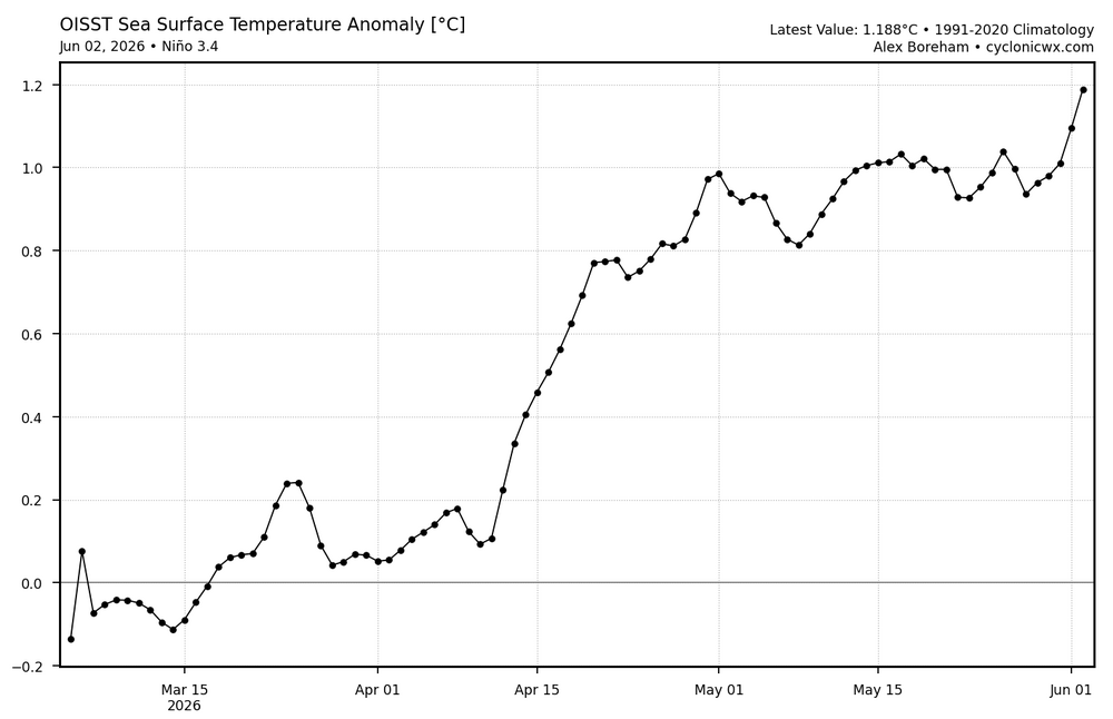
-
Perfection
-
The "wheel of misfortune" cut off still trying ruin it for Scott!
-
Well it is almost officially summer after all. Enjoy!
-
52 this morning. Felt fantastic on my run. Can't beat that for early June.
-

2026-2027 Strong/Super El Nino
snowman19 replied to Stormchaserchuck1's topic in Weather Forecasting and Discussion
-
Nice day, could be better yet could be much worse. Take
- Today
-
77° / 41° under clear blue skies. Doesn't get much better.
-

Central PA Summer 2026 Discussion/Obs Thread
WmsptWx replied to Voyager's topic in Upstate New York/Pennsylvania
Euro apparently showing the HEAT mid-month with GFS getting warmer, too. -
Chamber of Commerce Top 5 day!
-
Thank you Tip, I enjoyed the Op Ed. As a cement bound URI blessed denizen of the coastal plain I credit you with, sadly, a most accurate description of my cool/cold season, “four months of Autumn”. On the coastal plain this is less likely to be tongue-in-cheek. Unfortunately, as described by Hawkeye Pierce that Crab Apple Junction Maine has a white Christmas, beginning October 31st may also be less likely, nowadays. Still……. When the first real cold and threat of frozen, a flake, a mix and maybe accumulation appears, our local media, as do our forums, whoosh into a joyous anticipation. i, personally, find solace, in a calm warm summer night with gently falling showers. “Speak to me softly, like the rain” …… I still try to listen. As always…..
-
June 3 1955: Seven people are killed on Lake Traverse when their boat is overturned by strong winds from a thunderstorm. For Wednesday, June 3, 2026 1921 - A cloudburst near Pikes Peak CO killed 120 people. Pueblo CO was flooded by a twenty-five foot crest of the Arkansas River, killing 70 persons. Fourteen inches of rain was reported at Boggs Flat, where a hard surface road through nearly level country was washed out to a depth of seven feet. (The Weather Channel) 1959 - Thunderstorms in northwestern Kansas produced up to eighteen inches of hail near Salden during the early evening. Crops were completely destroyed, and total damage from the storm was about half a million dollars. Hail fell for a record eighty-five minutes. The temperature dropped from near 80 degrees prior to the storm to 38 degrees at the height of the storm. (David Ludlum) 1987 - Six days of flooding in South Texas culminated with five to six inch rains from Bexar County to Bandera County, and five to nine inches rains in Gonzalez and Wilson Counties. Total crop damage was estimated at 500 million dollars. (Storm Data) (The National Weather Summary) 1988 - Early morning thunderstorms in southern Texas produced wind gusts to 86 mph at Port Isabel, and wind gusts to 83 mph at South Padre Island. Unseasonably hot weather prevailed from the Southern Plateau Region to the Northern High Plains. Fourteen cities reported record high temperatures for the date. (Storm Data) (The National Weather Summary) 1989 - Thunderstorms developing over the Southern Plains Region during the afternoon hours produced severe weather into the night. Thunderstorms spawned eleven tornadoes, and there were 169 reports of large hail and damaging winds. Thunderstorm winds gusted to 80 mph at Newcastle, OK, and Wilson, OK. Softball size hail was reported at Monahans, Childress and Groesbeck TX. Monahans TX reported six million dollars damage. Five inches of rain deluged Geronimo OK. (The National Weather Summary) (Storm Data)
-

2026-2027 Strong/Super El Nino
LakePaste25 replied to Stormchaserchuck1's topic in Weather Forecasting and Discussion
-
There is some child-like novelty to the first snow and holiday snows, and occasionally interesting events, otherwise its just a beat down of darkness and nasty
-
2026-2027 Strong/Super El Nino
LakePaste25 replied to Stormchaserchuck1's topic in Weather Forecasting and Discussion
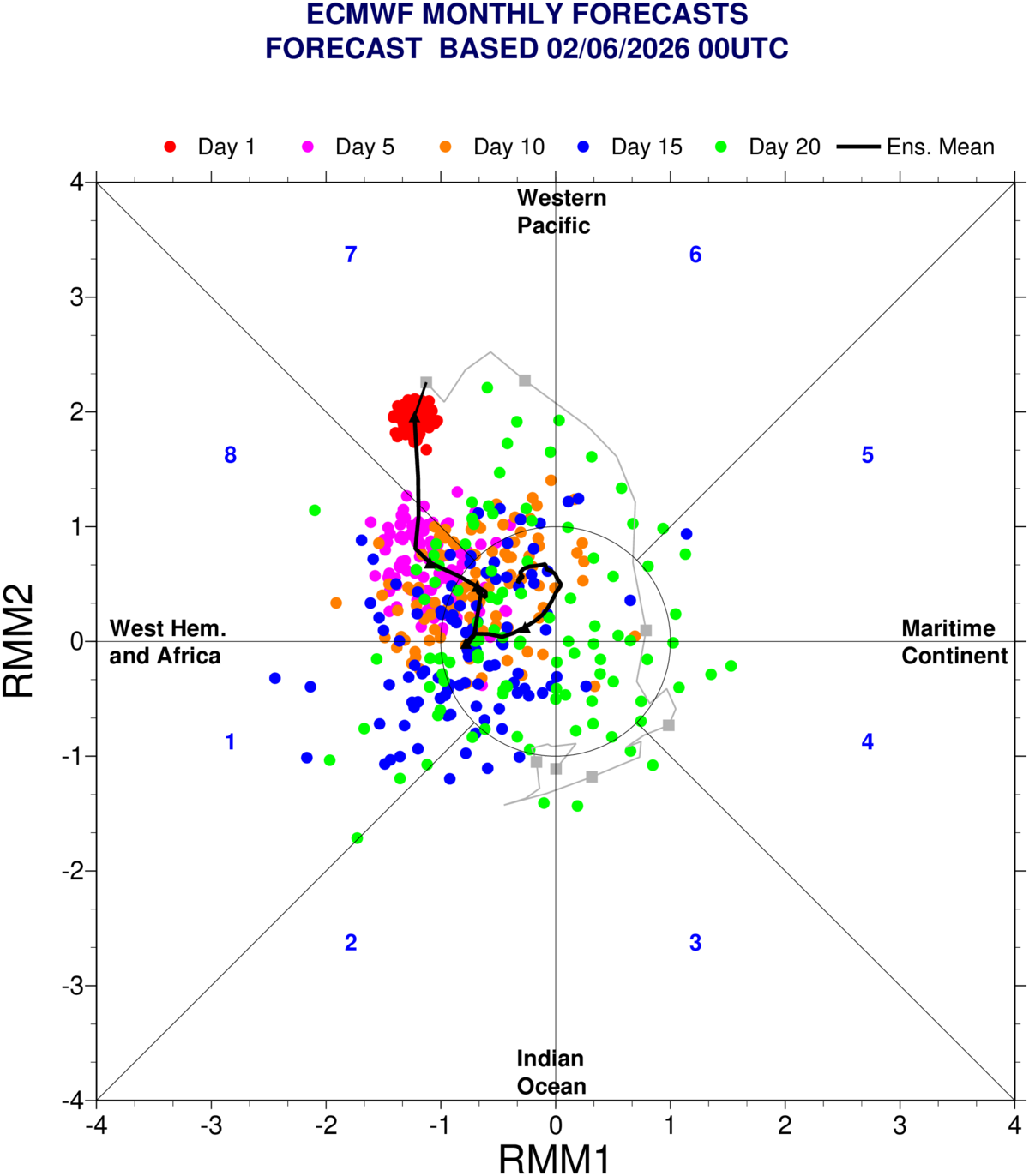
The EPS in particular seems to have a westward lean on the OLR map, which would push the RMM mean into the COD. I see less of a signal of this on the GEFS.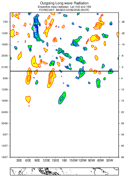

-

2026-2027 Strong/Super El Nino
donsutherland1 replied to Stormchaserchuck1's topic in Weather Forecasting and Discussion
Yes. Precipitation wasn't the problem. The region was flooded with too much warmth. It will be interesting to see how things unfold with the upcoming super El Niño. -
Op ed. I've always thought that was kind of ironic about winter vs summer group psychobabble when comparing the two disparate seasons in this particular social media. Who knows what the real numbers are ...something like 60/40 say of the average bloke preferring winter over summer? Sometimes I suspect it's steeper than that and can launch into a sardonic diatribe how/why. Heh. But what's ironic is that there are fantastic summer events to track - this is after all a weather-related forum ( yeah...right). The obvious response there would be, well ... 60+% don't find summer events very interesting. To that I would suggest the turn around time between events that make winter interesting - at all - is longer than the turn around time in what makes summer interesting. But they do...because when there is hail, or high wind, or flooding rain, or big heat... thread counts balloon just as well. We've had slow summers. Sure. This will undoubtedly trigger arguments from people who myelinate impressions and memories based on something other than objective numbers, but we observe summer-type phenomenon more frequently in summer. More so than we observe events of winter ... in winter. Although lately we can find value in the tongue-in-cheek that winters are turning into four months of autumn. A growing coherency that makes this even more ironic. I guess partly I'm driving at the notion that something else is motivating there. This is anecdotal so don't give one's self any wedgies over it, but I see more CB's on horizons and other fantastic cloud ops, heat in model ranges either home or abroad to the world, about as often as I'm also waiting weeks ...weeks sometimes in winter for anything at all to happen. To me, winter's most successful repeating phenomenon is darkness. Okay. To each is his or her own. One's preference is one's preference. And l do risk sounding hypocritical when I say, ...yeah, I like winter weather phenomenon ...when it happens. Otherwise, I don't forgo my opportunities to track heat ( as an actual meteorological phenomenon, make especially relevant in CC), thunder and CB/cloud formations, a more revealing female population ... Disc Golf, standard Golf, boogie-boarding in the surf. None of which can happen between January 5th and that teleconnector maybe-ims for late month that gets can-kicked to February 17th, and ends up screwing someone for some reason. But at least it's dark by 4pm
-

Central PA Summer 2026 Discussion/Obs Thread
NepaJames8602 replied to Voyager's topic in Upstate New York/Pennsylvania
43 this morning. Another great night sleep, with windows open. Natural a.c, can't beat it. -
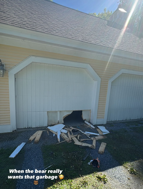
Bear break-in. These guys are tenacious.
-
(002).thumb.png.6e3d9d46bca5fe41aab7a74871dd8af8.png)
Central PA Summer 2026 Discussion/Obs Thread
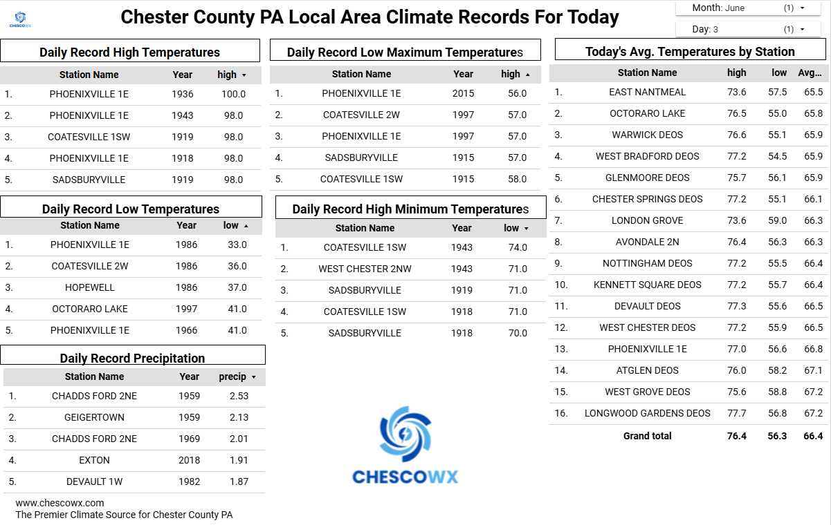
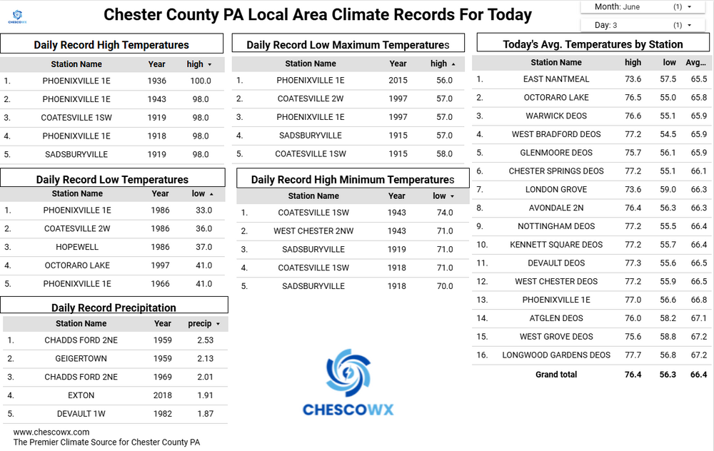
ChescoWx replied to Voyager's topic in Upstate New York/Pennsylvania
Through May this has been our coldest start to a year since 2015. We should finally see some above normal temperatures starting tomorrow and peaking at around 90 degrees by Saturday. We then see some increasing chances of showers by Saturday night with temperatures cooling back to near normal levels by next Monday.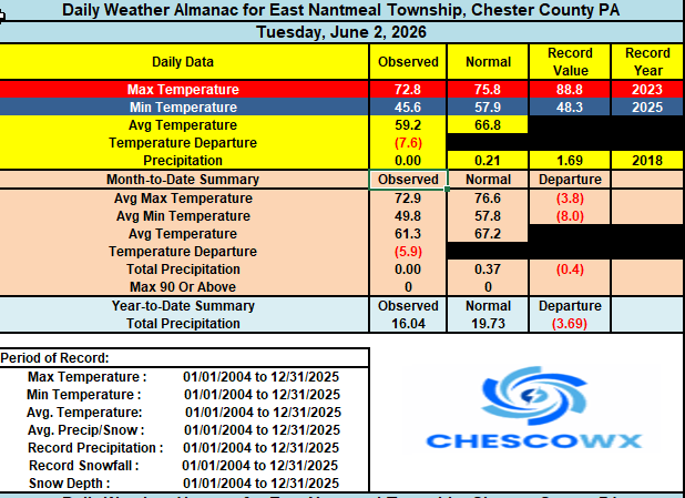
-
E PA/NJ/DE Spring 2026 Obs/Discussion
ChescoWx replied to PhiEaglesfan712's topic in Philadelphia Region
Through May this has been our coldest start to a year since 2015. We should finally see some above normal temperatures starting tomorrow and peaking at around 90 degrees by Saturday. We then see some increasing chances of showers by Saturday night with temperatures cooling back to near normal levels by next Monday.
-

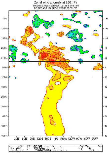
2026-2027 Strong/Super El Nino
so_whats_happening replied to Stormchaserchuck1's topic in Weather Forecasting and Discussion
Any thoughts to why we still seem to be crashing hard in Phase 7 to COD/weak 8 for MJO? We saw this in 23/24 as well. -
 Roger Ramjet changed their profile photo
 -
This morning was a refreshing low of 60 at KSAV and 64 at KSVN. Dewpoints are in the very nice/rare for June mid 40s. So, needless to say, I intend to walk at one of the parks this evening as I did yesterday.


.thumb.gif.f92b16c631a1d15d405ed77b33f0710d.gif)