All Activity
- Past hour
-
After some overnight showers and perhaps a thundershower, it will turn somewhat cooler tomorrow with highs reaching the lower and middle 50s. Another cold front could cross the region on tomorrow night or Friday. The front will bring a few showers or thundershowers. The weekend will start on a cold note with the low temperature likely near or even somewhat below freezing in New York City and high temperatures in the middle 40s on Saturday. Sunday will become somewhat milder. The ENSO Region 1+2 anomaly was +1.6°C and the Region 3.4 anomaly was 0.0°C for the week centered around March 18. For the past six weeks, the ENSO Region 1+2 anomaly has averaged +1.15°C and the ENSO Region 3.4 anomaly has averaged -0.08°C. Neutral ENSO conditions will continue through at least mid-spring. The SOI was -9.10 today. The preliminary Arctic Oscillation (AO) was +2.529 today. Based on sensitivity analysis applied to the latest guidance, there is an implied near 100% probability that New York City will have a warmer than normal March (1991-2020 normal). March will likely finish with a mean temperature near 45.8° (3.0° above normal). Supplemental Information: The projected mean would be 3.3° above the 1981-2010 normal monthly value.
-
Got first mow of the season done today.
-
Quality day today. Was able to head down to see the kids pony. She is shedding like crazy and I washed her tail and mane from all the winter crud that gets in there. Came home and put our deck back together from when we pinned everything down from the wind storm potential a couple of weeks ago. Daffodils out front are in full bloom and some of my deck perennials in pots are coming up.
-
68 my high, now 60
-
Same here after a high of 76.
-
URGENT - IMMEDIATE BROADCAST REQUESTED Tornado Watch Number 75 NWS Storm Prediction Center Norman OK 450 PM EDT Thu Mar 26 2026 The NWS Storm Prediction Center has issued a * Tornado Watch for portions of Northern Half of Ohio Western Pennsylvania West Virginia Panhandle Lake Erie * Effective this Thursday afternoon and evening from 450 PM until 1100 PM EDT. * Primary threats include... A couple tornadoes possible Scattered damaging winds and isolated significant gusts to 80 mph likely Scattered large hail and isolated very large hail events to 2 inches in diameter likely SUMMARY...Scattered severe thunderstorms are forecast to develop and intensify through the late afternoon and into the evening. A mix of supercells and organized line segments will pose a risk for large hail, severe gusts, and the possibility for a couple of tornadoes. The tornado watch area is approximately along and 60 statute miles north and south of a line from 60 miles west of Findlay OH to 35 miles southeast of Franklin PA. For a complete depiction of the watch see the associated watch outline update (WOUS64 KWNS WOU5). PRECAUTIONARY/PREPAREDNESS ACTIONS... REMEMBER...A Tornado Watch means conditions are favorable for tornadoes and severe thunderstorms in and close to the watch area. Persons in these areas should be on the lookout for threatening weather conditions and listen for later statements and possible warnings. && AVIATION...Tornadoes and a few severe thunderstorms with hail surface and aloft to 2 inches. Extreme turbulence and surface wind gusts to 70 knots. A few cumulonimbi with maximum tops to 400. Mean storm motion vector 28045. ...Smith
-

E PA/NJ/DE Spring 2026 Obs/Discussion
BBasile replied to PhiEaglesfan712's topic in Philadelphia Region
Damn, this weather!!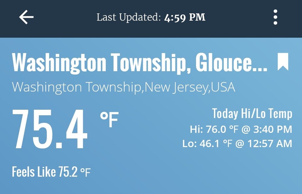
.thumb.jpg.933ec4bfabddb5d3c476cd2aa97a12bf.jpg)
-
Will feel like a mid winter day if you're not in the sun
-
I told him the other day that the NAO has been verifying more positive than those d14 mean progs since mid Feb. Looks like the AO has since 3/1 too.
-
HRRR has snow flurries for Saturday
-
I tried +10 and disliked it lol. Now 110 and humidity is a problem. At that point, I’m moving to northern Cali and breaking even.
-
What a run Phoenix is on. 1 March 100° on record before they obliterate the record book with 8 straight. Up to 98° so far today.
-
this past Sunday night I witnessed the biggest hail in my life. Literally thought our windows were going to break. I think 1.5" was what they recorded. Hail? No thanks although I know it's very likely in this set up. off topic but the last three months has featured some pretty crazy weather for us starting with that big dog in late January, a widespread windstorm a few weeks back, the hottest day ever recorded in March a week ago, the hail storm last week, greatest temp drop in like 8 hours, (or something like that)... definitely hasn't been boring.
-
Managed 60.6° here despite no sun!
-
This was a fail. That's why long range forecasts shouldn't be taken seriously.
- Today
-
Jelly
-

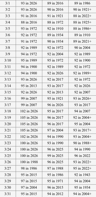
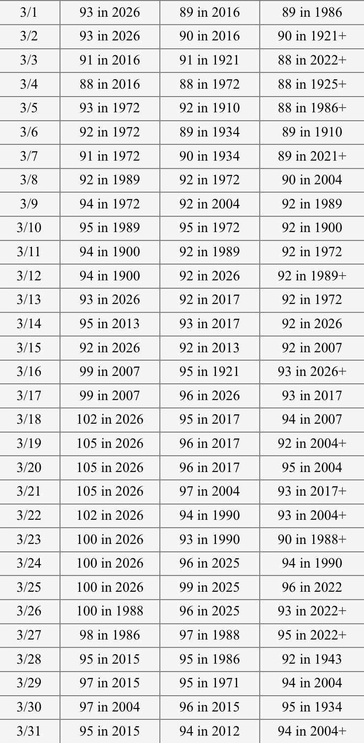
Chester County PA - Analytical Battle of Actual vs. Altered Climate Data
Cobalt replied to ChescoWx's topic in Climate Change
Unironically posting a graph like that should get you banned from any scientific community ever. The absolute failure of even Stats 101-level thinking is abhorrent to a degree where it feels like Chesco is playing a persona. -
here we go! getting a little windy, still a few hours to go.
-
72
-
72°
-

Central PA Spring 2026 Discussion/Obs Thread
canderson replied to Voyager's topic in Upstate New York/Pennsylvania
80 at home today -
Any Tor threat with this is if a surface low can spin up with a strong enough W/NW flow (or super cell outflows, unlikely but non zero). Hell (hehe) the current surface low looks more like a strung out wave. Theres a stout SW around 700mb racing east out of Kansas/Nebraska with a surface reflection but even with it there's no backing flow yet. SPC addresses this in their latest write up. Backside elevated hailers with this moist HOT lol, surface air being flat out jammed upwards into the very cold air aloft by the strong CAA a bigger deal. Might see hail once every couple years where I live, seen it twice in a little more than a week. Last one (similar to this setup) covered the ground completely. Me know likey hail
-
Overcast but truck reading 70…feels fabulous.
-
77 here. 50 along the waterfront
-
Seems they're fighting seasonal change, huh I've seen something like this every spring around this time frankly going back years. It would be an interesting discussion to have with the modelers at NCEP...but it seems as though their physics are not integrating for steadily increasing heat input into the system. They just take whatever they see in the initialization, and then out in time they end up too cold So by the time we get to mid April the sun is like mid August. Hot as hell on sunny days. Sometime between now and 2.5 weeks .. I mean give it up. Only once or twice do I recall an air mass cold enough to offset that, way back prior to 2000 ... and these patterns in the current model depictions ain't it.


.thumb.jpeg.f5c6ba9d911ec96b3b124f8606aee58e.jpeg)

