All Activity
- Past hour
-
March 2018 would like a word. The problem with this is we’re relying on a very fragile setup that could easily fall apart at this lead time and cold air is lacking. We need a dynamic system to create the cold air essentially and a favorable track.
-
Index method says pump breaks, but we'll see. Anomalies relative to indexes can happen. It's rarer but, if the relay off the Pacific is more powerful ... that can offsets the plummeting PNA. That's about the only way; because otherwise the falling PNA means rising anti-cyclonic forcing. So if your trying to mechanize a cyclone in the midst of raising anti-cyclonic means... that both intuitively, and geo-physically/mathematically is going to introduce some challenges. The GEFs/GFS is physically subsuming the ejected wave space with -d(PNA) in keeping with the above concept. The EPS/Euro, does less of that ... It's also quite a bit strong/more coherent looking as the relay off the Pacific down near the upper Baja is taking place. It's almost like threading the needling at a pattern scale, not at the wave space... The integration of the ejected wave space with the surrounding medium is very decimal determined - so to speak. If the surrounding -d(PNA) is overly applied in the GFS even fractionally, that in step is giving something more to the eject wave space and its coherency then means a different fate ..etc. If the it is however more correct, the Euro's full of shit. Brian's also right about those idiosyncratic feature handling; they'll play a role. But suspect getting the above ironed out is just as if not more important - more damping (GFS) and it's a moot
-
Where does rain go when the ground is over 2 feet thick frozen.... hmm idk no where..... unless your talking about reservoir related...
-

E PA/NJ/DE Winter 2025-26 Obs/Discussion
LVblizzard replied to LVblizzard's topic in Philadelphia Region
When the GFS is on its own, it’s wrong more often than not. -

Is we back? February discussion thread
RUNNAWAYICEBERG replied to mahk_webstah's topic in New England
20% chance…well, I’m all in then. -
I think Dendite mentioned this earlier. 6z Euro has that northern stream vortex basically slide due east through central Quebec, whereas 0z had it about 500 miles further SE diving through Eastern Maine. That was a huge difference, though a lot of the models are all over the place with that feature.
-
That's why I said 20% we get something. 50% it still misses completely but its not a situation where being on the northern edge means we get snow
-
Sun went back into hiding but it did its job. Up to 38° now
-
robins have been 12 month residents here for so long now
-

Is we back? February discussion thread
40/70 Benchmark replied to mahk_webstah's topic in New England
Euro Sky net (Left) Matches EPS (Right) pretty well. Def tighter clustering on Skynet and more spread on EPS. -
Jesus Christ some people are unbearable lately on here. I get that many are sick of winter but wishing it away isn’t going to work. Why, suddenly, are so many people saying winters end in mid February in our region? That is statistically and categorically false. On a probability standpoint we just past the most snowy portion of winter. It doesn’t completely drop off. Growing up St. Patty’s day really felt like the end of winter with ski areas turning more to slush and yards melting. I’d be very very shocked if we put up a goose egg the rest of winter.
-
Pretty funny how yesterday afternoon many models had this tracking well south, now it is obviously an interior threat.
-
This is true-you'll need something that tracks 75 miles off the coast to the BM. A hugger will not work whereas a week ago it would have mostly worked given the airmass in place.
-
Nothing wrong with weirdos. Always told our kids they got the short straw with their parents. One a Game Animator and the other an Artist who fixates on weather, transportation, and animals. Always told them if everyone was the same we would live in a very boring place. Must have done something right. One going the film track and the other enjoys studying dead peoples bones.
-
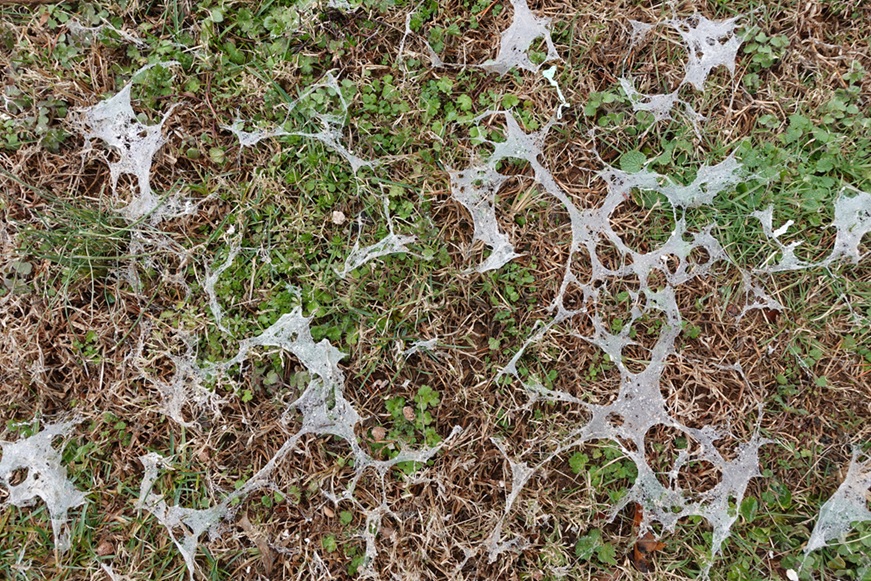
I had a very mild morning low of 45.9° after a high yesterday of 66.2°. This morning was the first since January 14th that the temperature didn't fall below freezing overnight in my backyard. Yesterday was a big snowmelt day and in its wake, I have noticed a few patches of snow mold.
-
Is we back? February discussion thread
40/70 Benchmark replied to mahk_webstah's topic in New England
Obviously 06z is closer, but you can also see we're losing the high to the north. -
While I'm not sure it is a phenomenon per say, one thing that jumps out to me happened a few years ago. I was flying back into BWI from Detroit, and it occurred during the decent into landing. Near Frederick you could see pretty good snow fall coming down out the window lit up in the plane's lights. However, once we were down lower and, on the ground, it was all coming down as rain due to the temps. It was so wild to me to see the warm layer melting the snow in person over a few minutes, okay more than just a "layer" in this instance.
-

Feb 10-11 Mid Week Minor Event - Ride the hot hand?
tamarack replied to HoarfrostHubb's topic in New England
4.7" with 0.35" LE, right in the forecast range. Pack back up to 22". Most probably fell 11 PM-2 AM. -
(002).thumb.png.6e3d9d46bca5fe41aab7a74871dd8af8.png)
E PA/NJ/DE Winter 2025-26 Obs/Discussion
ChescoWx replied to LVblizzard's topic in Philadelphia Region
Winter grade through today for a winter weather enthusiast a solid A IMHO.....Well below normal temps / above normal snowfall / record below 32 max streak / Top 20 consecutive snowcover streak -
Is we back? February discussion thread
40/70 Benchmark replied to mahk_webstah's topic in New England
06z Left, 00z Right -
Dendrite stole my avatar.
-
My main concern is it will be in the 40s this weekend and no cold air around. The storm will have to bomb out to have any shot at getting wet snow. Its pretty obviously an interior threat right now with maybe a 20% chance of accumulating snow at the coast
-

Central PA Winter 25/26 Discussion and Obs
pawatch replied to MAG5035's topic in Upstate New York/Pennsylvania
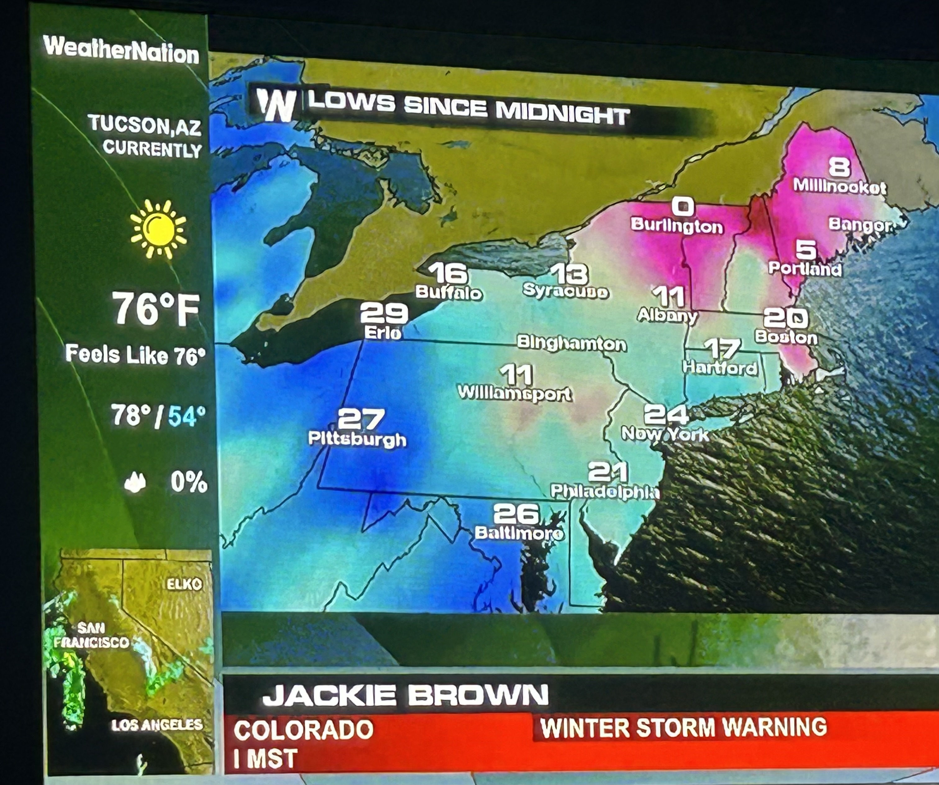
38 degrees currently, probably shorts weather for some of you. Sundays storm another difficult one to pin down.Thanks to everyone trying to figure it out. Found this interesting on weather nation. Was talking about Williamsport and how cold they have been. Monday this was on.
-
Whatever happens though, this period has been well discussed since really the beginning of the month. Obviously it's going to suck big time if this doesn't pan out but it goes to show that 1) Periods of potential can be sniffed out beyond 10 days 2) How the pieces move and evolve ultimately play a significant role in the outcome
-

Is we back? February discussion thread
Prismshine Productions replied to mahk_webstah's topic in New England
Yeah I do too Sent from my SM-S166V using Tapatalk